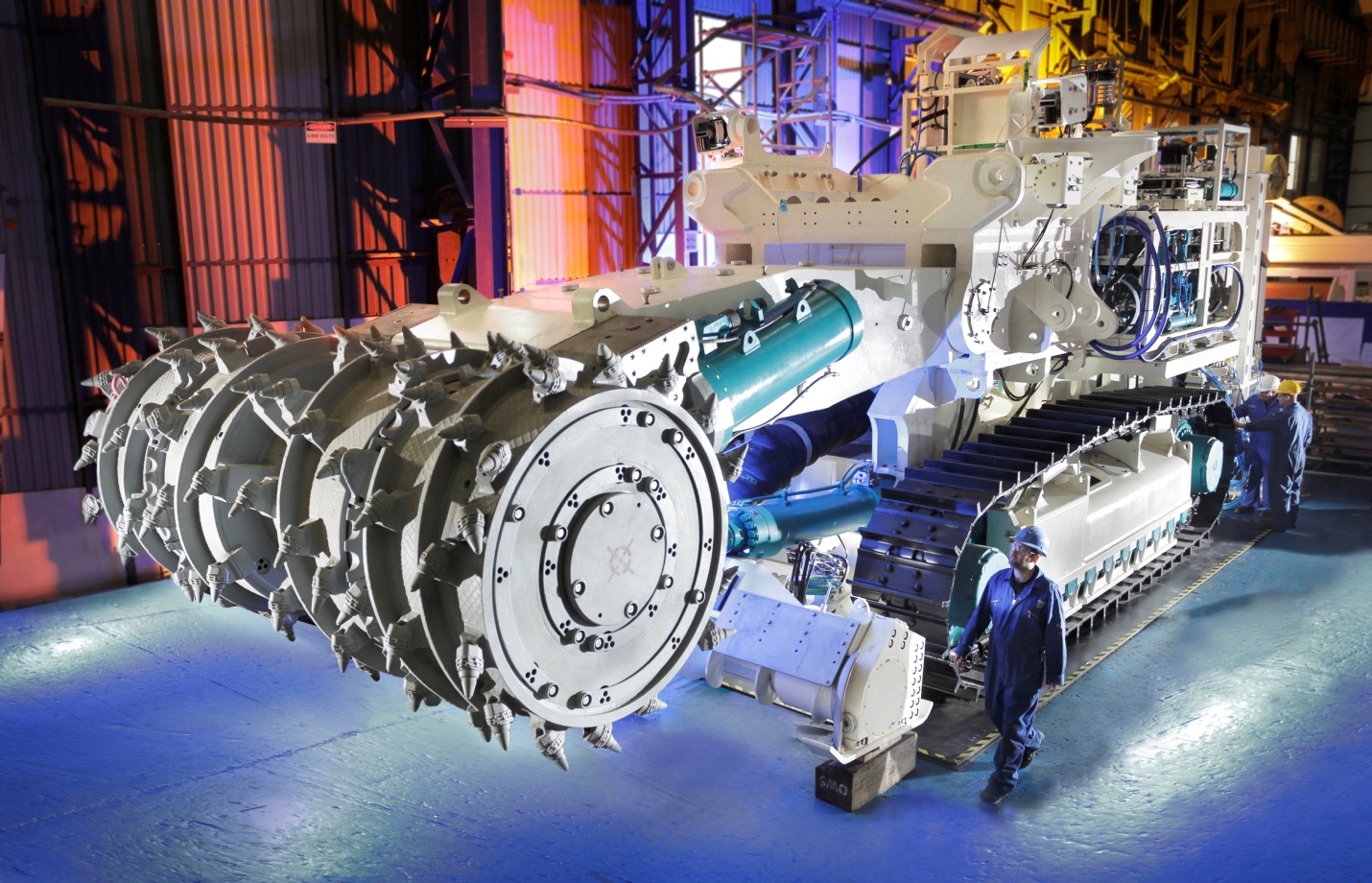
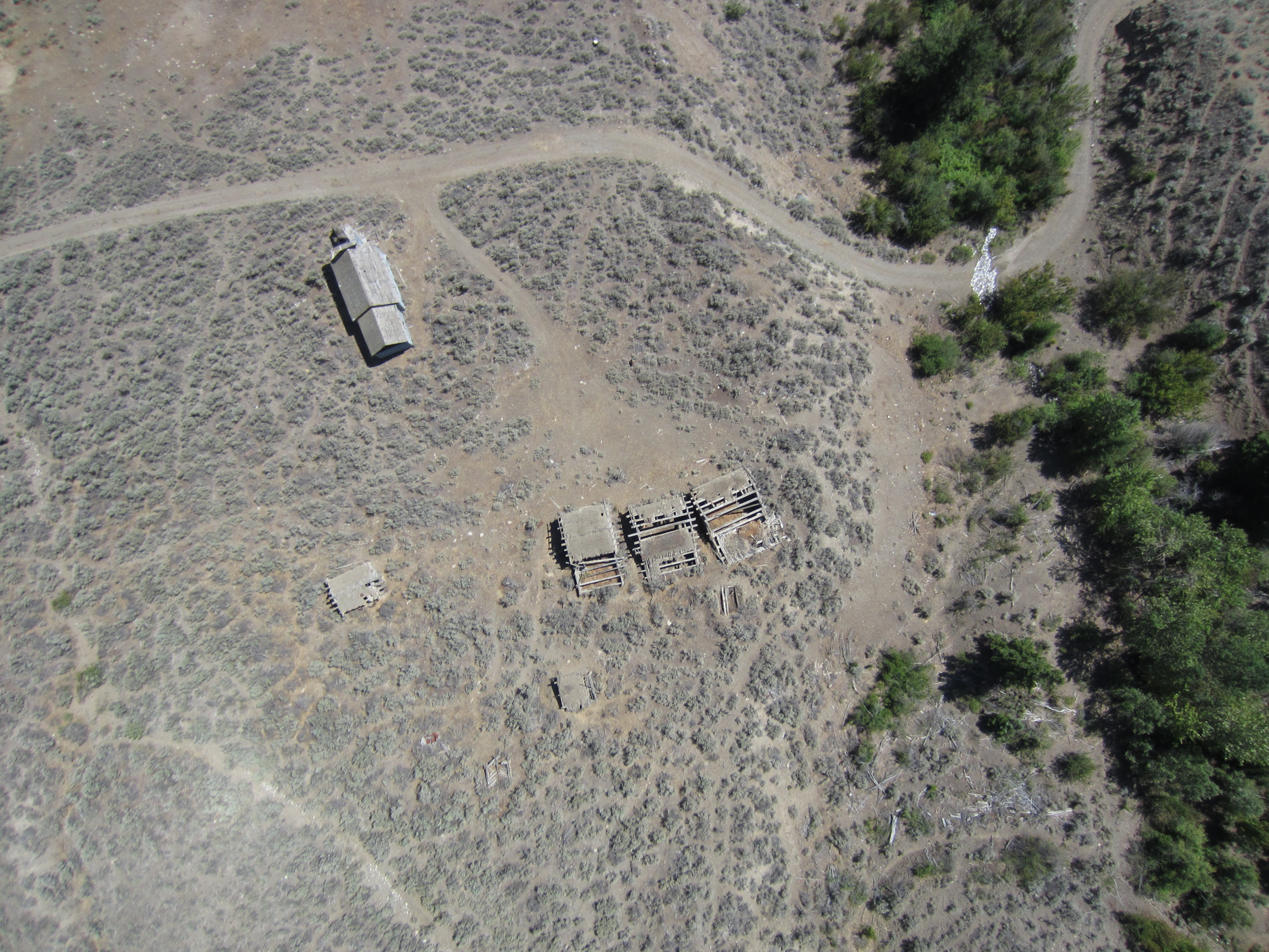
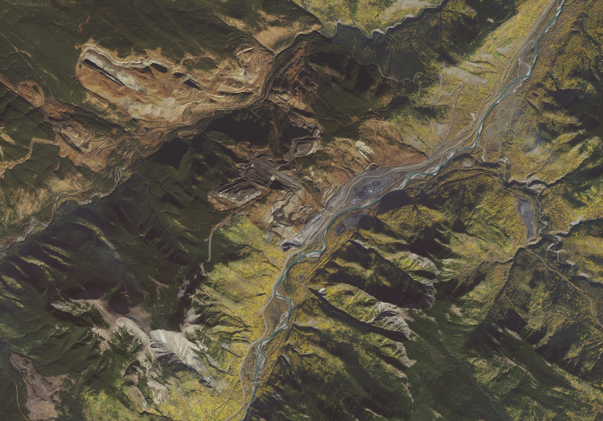
West Coast Placer was contracted to conduct high resolution aerial drone mapping of a coal mine in Alberta, Canada. We were hired by the environmental department to map two parts of the coal mine to aid in their reclamation efforts. We produced high resolution imagery and 3D models.
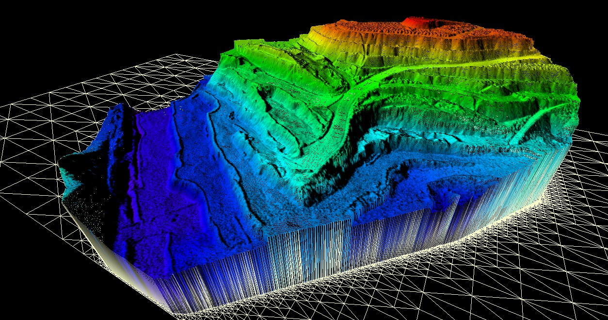
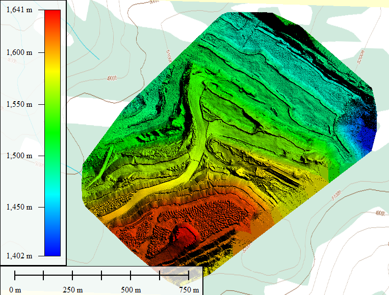
3D DSM
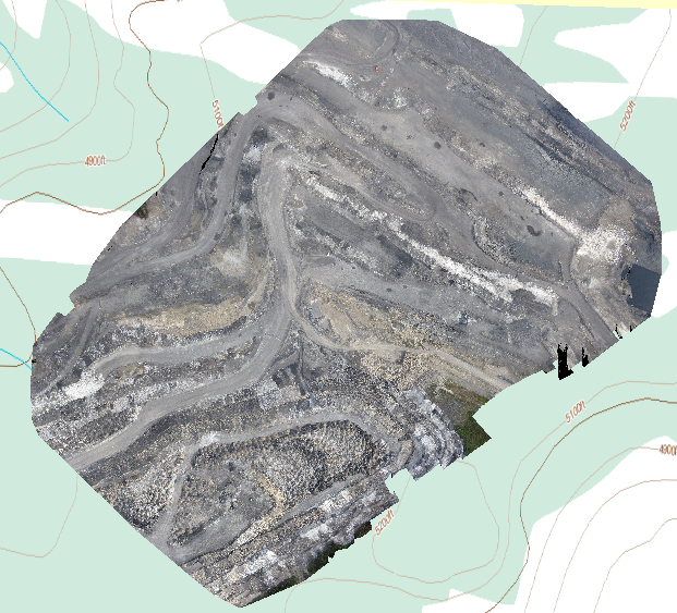
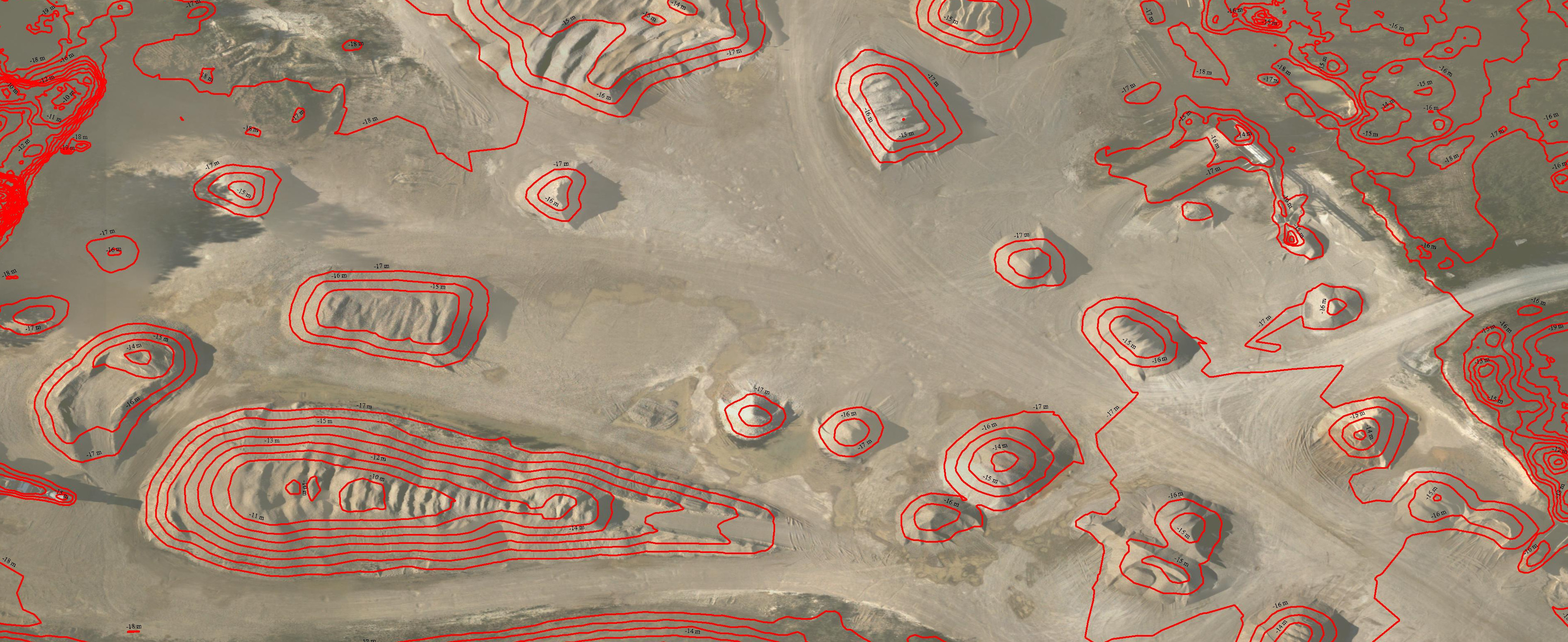
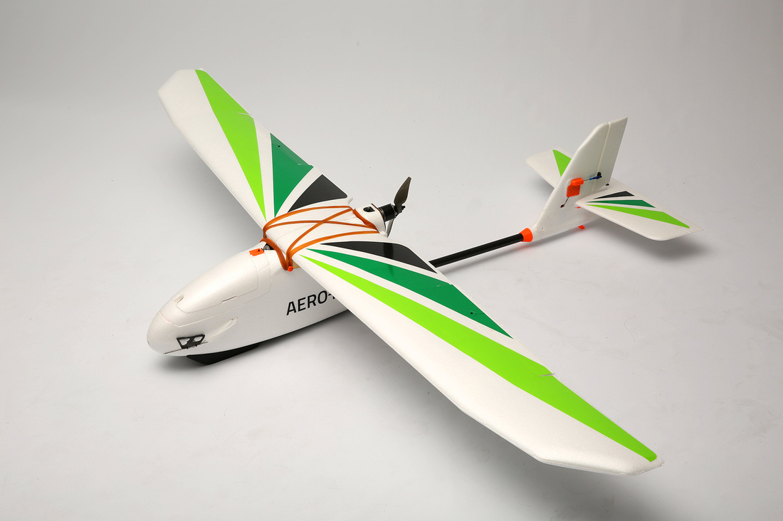
With our fixed wing mapping drone we were able to produce several custom mapping and imagery products. We made a beautiful high resolution orthophoto, a digital surface model (DSM) with topographical accuracy up to 30cm, a LAS format point cloud and one more 3D model. We were also able to format the 3D data so that it could be used in their mine planning software (Minesight).
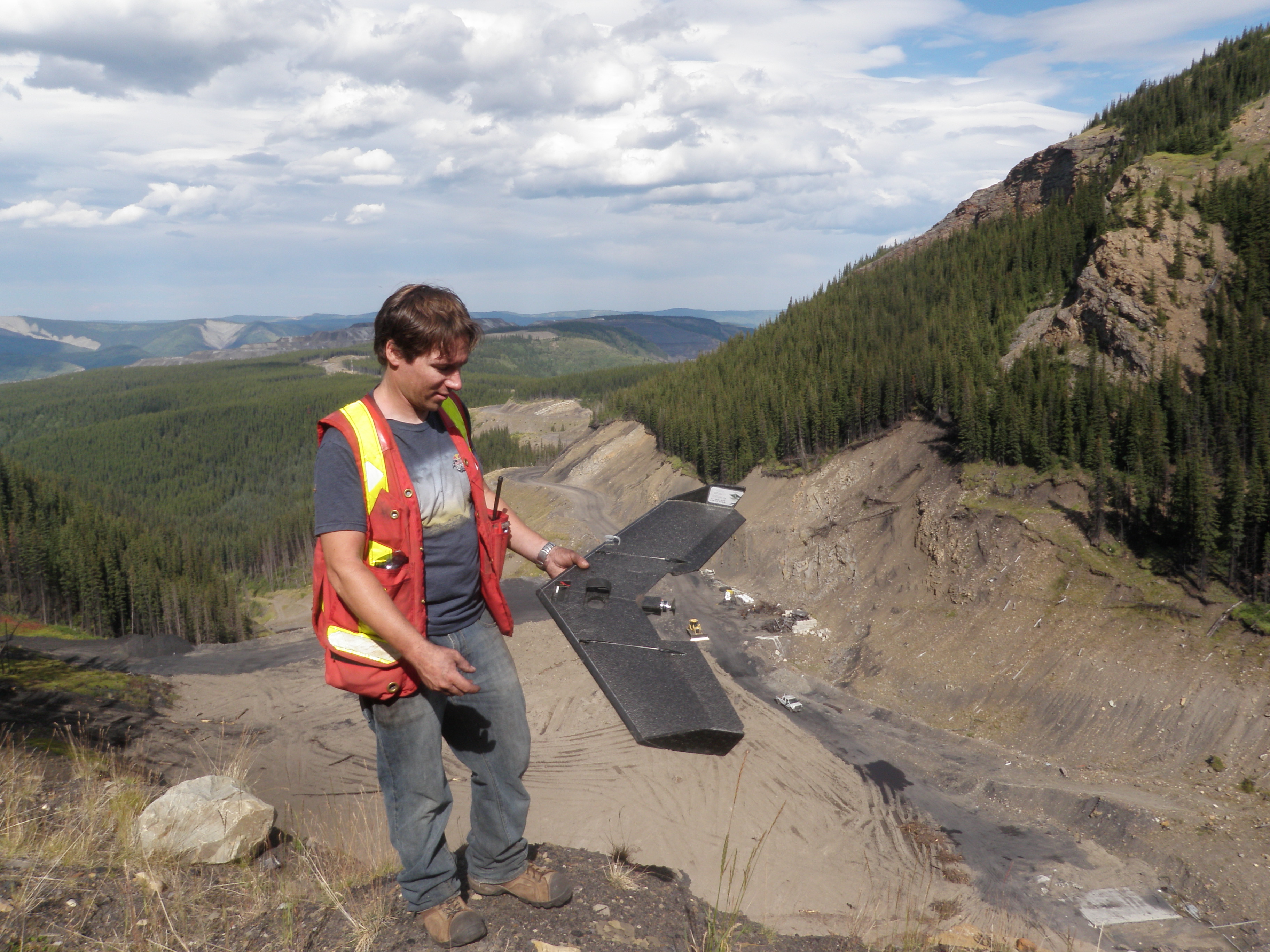
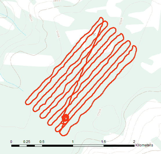
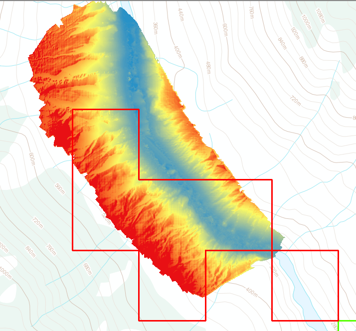
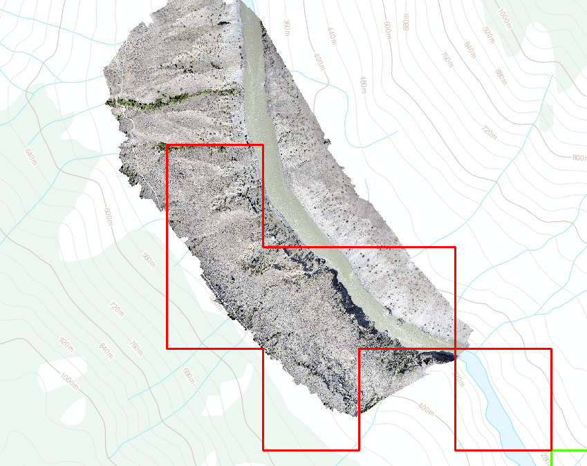
Two sections of the mine were surveyed. We flew a total of three flights in the same day. The mine asked to have the main pit flown two times to confirm the accuracy and repeatability of the data. We were happy to oblige and of course the flights matched within 2cm of each other. Each section that was flown was about 2 square kilometers and our drone has the flight duration to cover each section in one flight.
UAV Flight Path
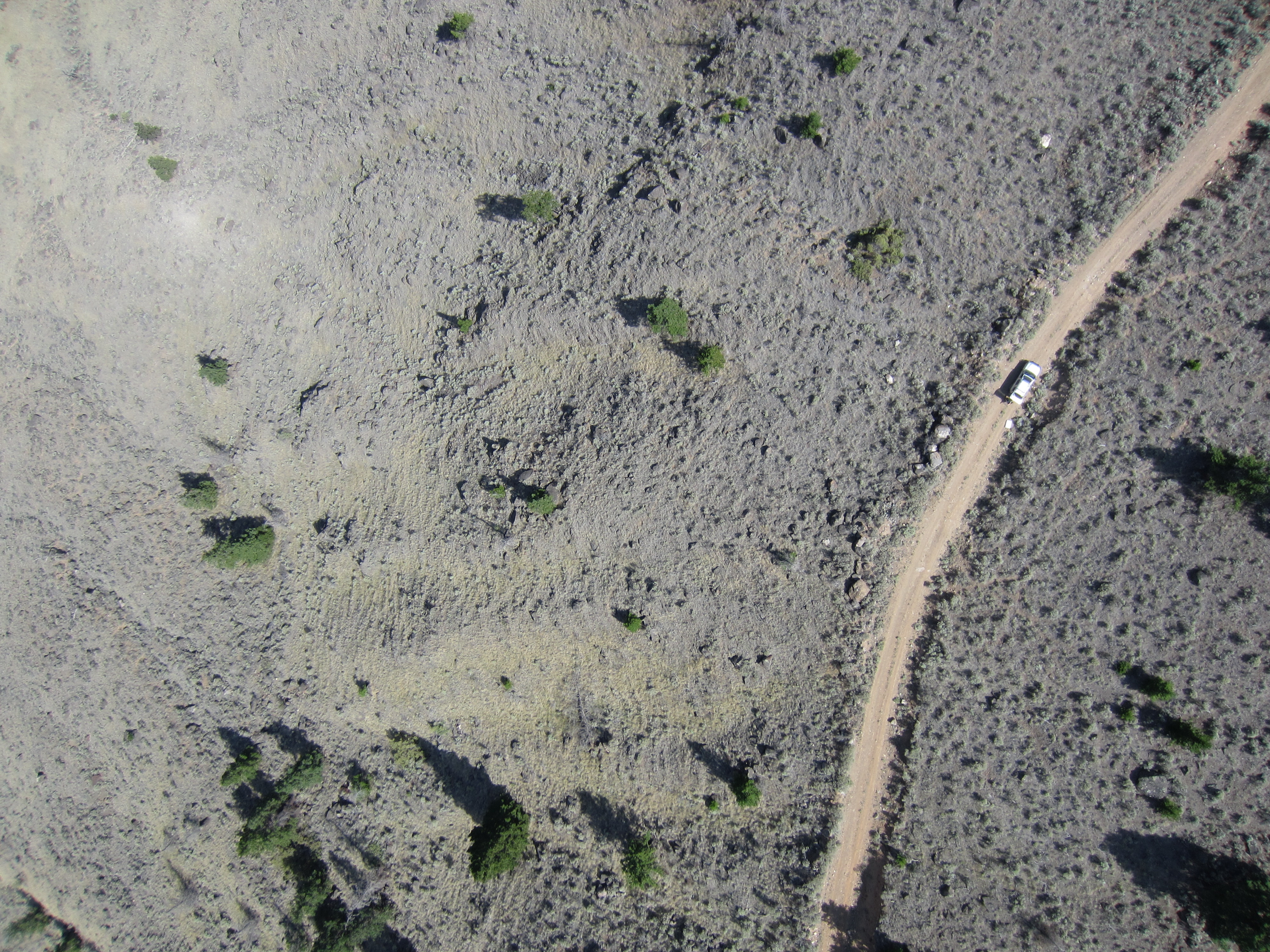
The photo quality on the still photos and orthomosaic was outstanding. We were able to achieve an image resolution on the georeferenced mosaic of 4cm/pixel. That means that each pixel in the photo represents a real world footprint of 4cm by 4cm. That kind of resolution cannot be matched by current satellite imagery providers. Actually they are not even in the same league. The best satellite imagery that you can buy today is provided by WorldView-3 satellite and has a resolution of 31cm/pixel. It also costs a lot of money. Google Earth come in at a pitiful 65cm/pixel in the best locations.
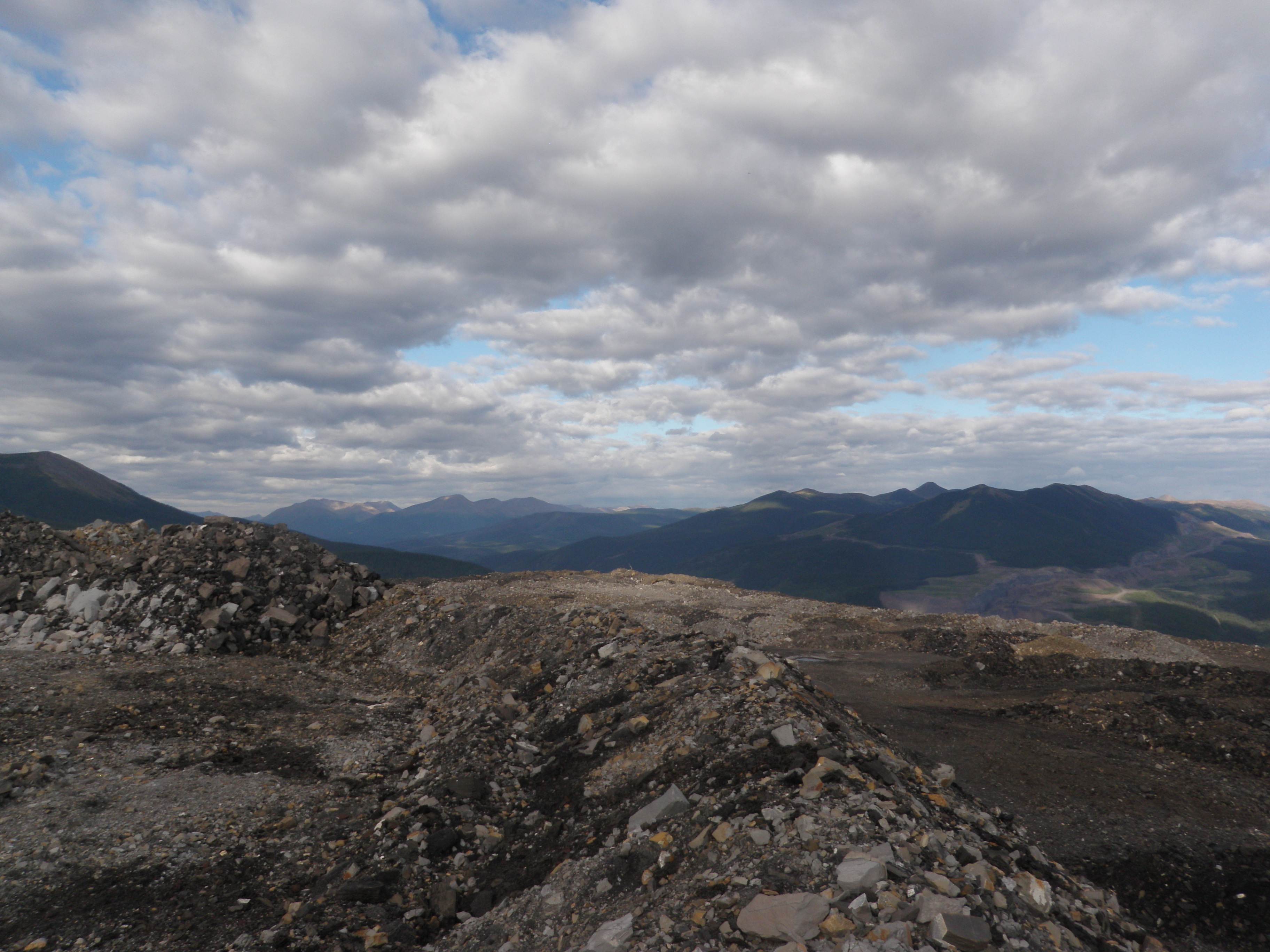
View from the top of the pit
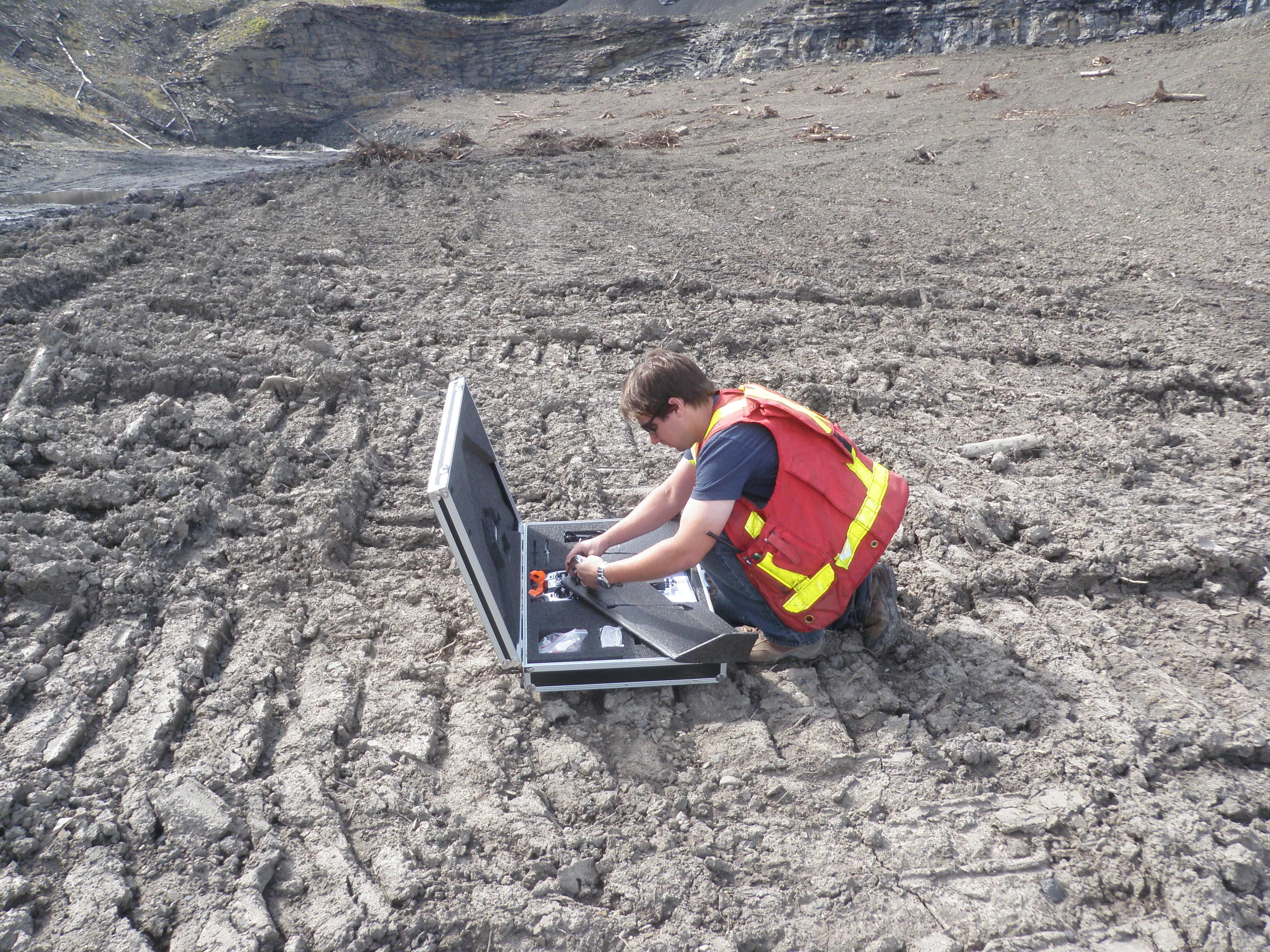
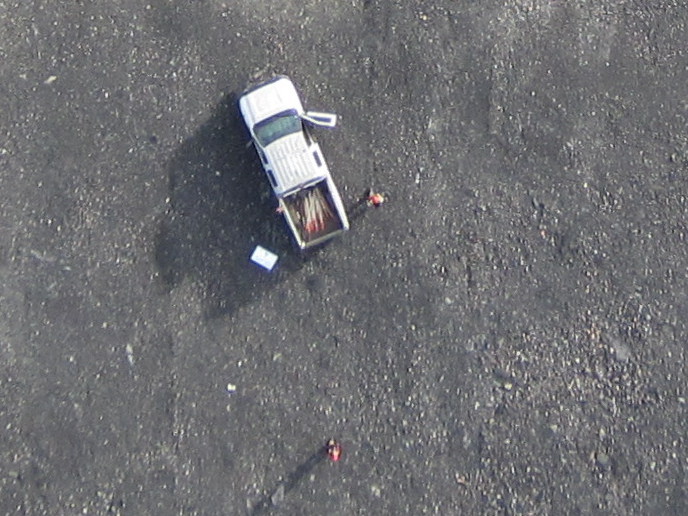
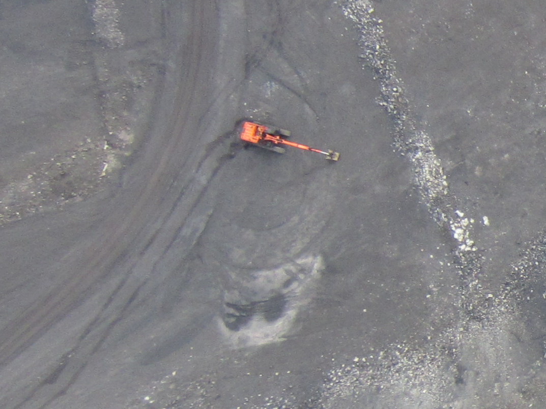
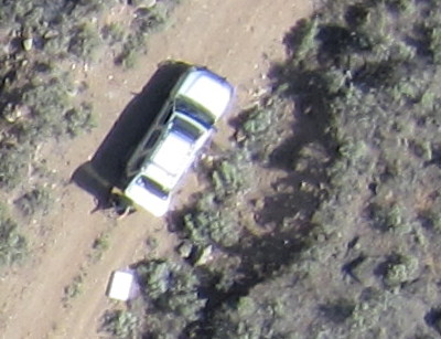
Here are some examples of our imagery. First is a shot of the truck that we used as a base station for the drone. You can clearly see the truck, the two operators and even the pickets in the bed of the truck. You can click on these images for a larger view.
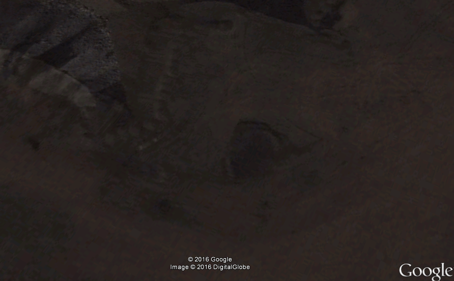
Here is a Google Earth image of the exact same location. I love Google and everything that they do but this image is just no comparison. To start with it’s three years old (despite the 2016 copyright note at the bottom), the mine does not even look like that today. The resolution is so poor that you can’t even tell what you’re looking at.
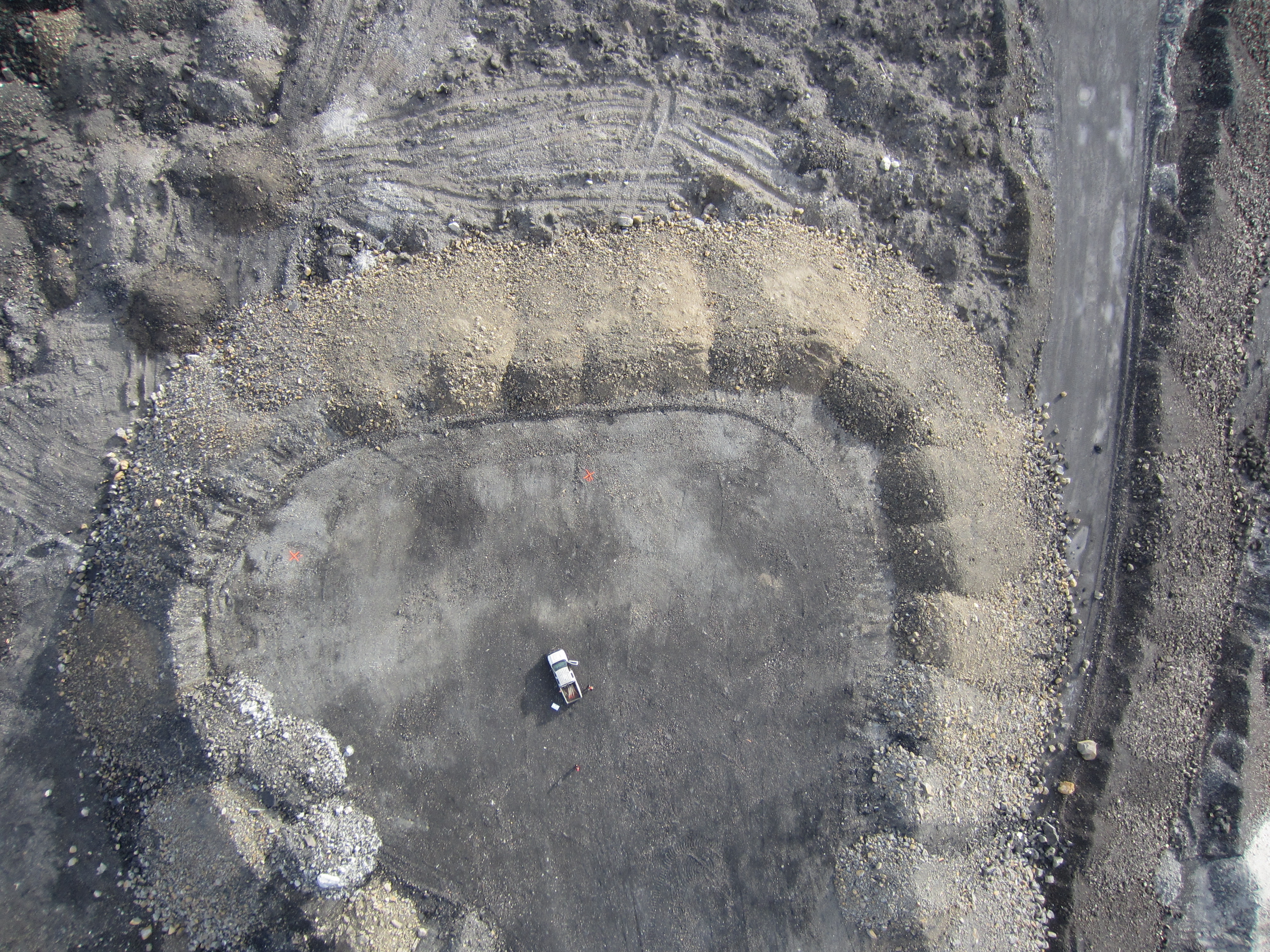
Here are a couple more shots from the same flight. You can clearly see this orange excavator and other details.
The 3D data is also incredible. Check out the video below for a great example of the 3D data that we produced. That video shows a virtual fly though of a LAS point cloud. LAS is the same format that LiDAR data produces.
Drone technology is just making it’s way into the mining world. With the low cost and amazing imagery it is a no brainer for many applications. In the case of this coal mine the environmental team now has excellent data to aid in their reclamation planning that would not have been available only a couple years ago. Check out this post on drone applications in mining.
Our client was very happy with the products that we produced especially for the price. Check out our Drone Services page for details on pricing.
Mining under Earth’s oceans is just starting to happen. We have gotten pretty good at mining deposits that are accessible by land but 71% of the Earth’s surface is covered by water. To date no large scale mining operation has succeed under the ocean which means that it’s all virgin ground.
Amazingly the human race has spent more time and money exploring outer space than we have under our own oceans. Over 500 people have been to space while only three have ventured to the deepest part of the ocean, the Mariana Trench. We have better maps of the surface of Mars than the bottom of the ocean, although the ocean maps are pretty cool.
The same geological processes that happen on land also take place under the ocean. There are volcanoes, mountain chains, faults and earthquakes. All the same types of mineral deposits occur under the ocean such as epithermal gold, porphyry, and placer. There are also diamond pipes, massive sulphides and everything else that we mine at the surface.
Deposits
The ocean also has types of deposits that we can’t find on land. One special mineral deposit is called Polymetallic Nodules. These are concretions of metallic minerals that occur under the ocean. The nodules grow sort of like stalactites do in a cave, over time layers of metallic minerals precipitate out of seawater and add to the nodule. The growth of nodules is one of the slowest known geological processes taking place at a rate of one centimetre over several million years.
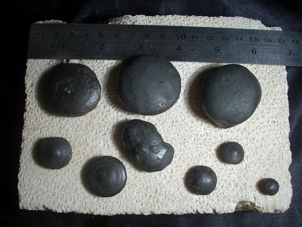
Polymetallic nodules are roughly the size and shape of a potato and contain primarily manganese as well as nickel, copper, cobalt and iron. They can be found on the sea floor or buried in the sediment. Nodules can technically occur anywhere in the ocean but seem to be in greatest abundance on the abyssal planes around 5000m deep. Nodule mining would be similar to placer gold mining except under water.
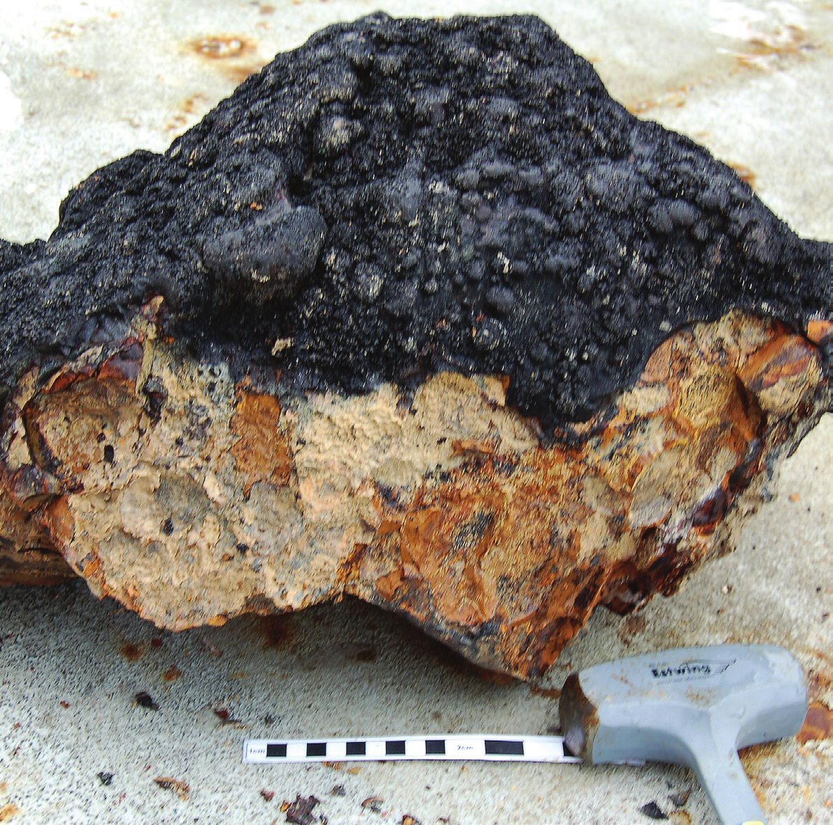
Anouther resource that is unique to the ocean floor is Ferromanganese Crusts. These are similar to nodules but occur as a coating on other rocks. These crusts can be found all over the ocean with thicknesses ranging from 1mm to 26cm. Ferromanganese crusts typically occur in the vicinity of underwater volcanoes called seamounts or near hydrothermal vents. Crusts with mineral grades that are of economic interest are commonly found at depths between 800m and 2500m.
Ferromanganese Crust
Ferromanganese crusts are composed primarily of iron and manganese, hence the name. Typical concentrations are about 18% iron and 21% manganese. Cobalt, Nickel and Copper occur in significant quantities as well. Rare earth metals such as Tellurium and Yttrium can be found in metallic crusts at much higher concentrations than can be found on the surface. Tellurium is used in solar panels and is quite valuable.
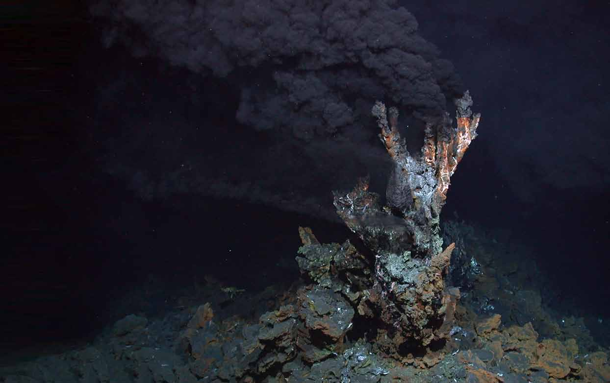
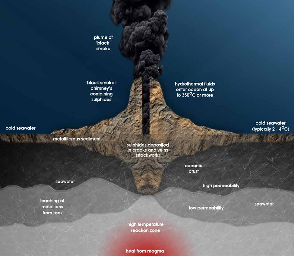
Sea-floor massive sulphides (SMS) are a younger version of volcanic massive sulphides (VMS). The two deposits are similar except that VMS are typically ancient and SMS are currently forming. SMS deposits occur where superheated hydrothermal fluids are expelled into the ocean. They typically form around black smokers near continental rift zones. SMS are know to hold economic concentrations of Gold, Copper, Silver, Lead, Nickel and Zinc.
Black smokers create SMS deposits by expelling superheated sea water that is rich in metallic elements. Cold sea water is forced through the sea floor by the pressure created from the weight of the water column above it. The water is then heated to temperatures in excess of 600°C when it is brought close to the magma that lies below. The heated water becomes acitic and carries with it a high concentration of metals pulled from the surrounding rocks. Once the hot, metal rich, water comes into contact with cold sea water the metals crystallize and deposit on and around the black smoker.
Mining
Large scale ocean floor mining has not taken off yet. Attempts have been made since the 1960s and 70s but failed due to technological and financial challenges. Small scale shallow ocean mining has been a lot more succesful in recent years. A great example is the popular TV show Bering Sea Gold. The miners in Nome Alaska are using modified suction dredges to comb the sea floor in shallow waters.
Currently proposed sea floor mining ideas are essentially super high-tech placer mining. They involve ways to dig through the surface layers of the ocean floor, bring the material to the surface and ship it to a processing facility. Its a lot like dredging but on a massive scale. As mentioned above, normal hard rock deposits also occur under the ocean but no plans have been proposed to build open pit mines under the ocean. That would involve all the challenges of building a mine on land with the added complexity of operating under the ocean.
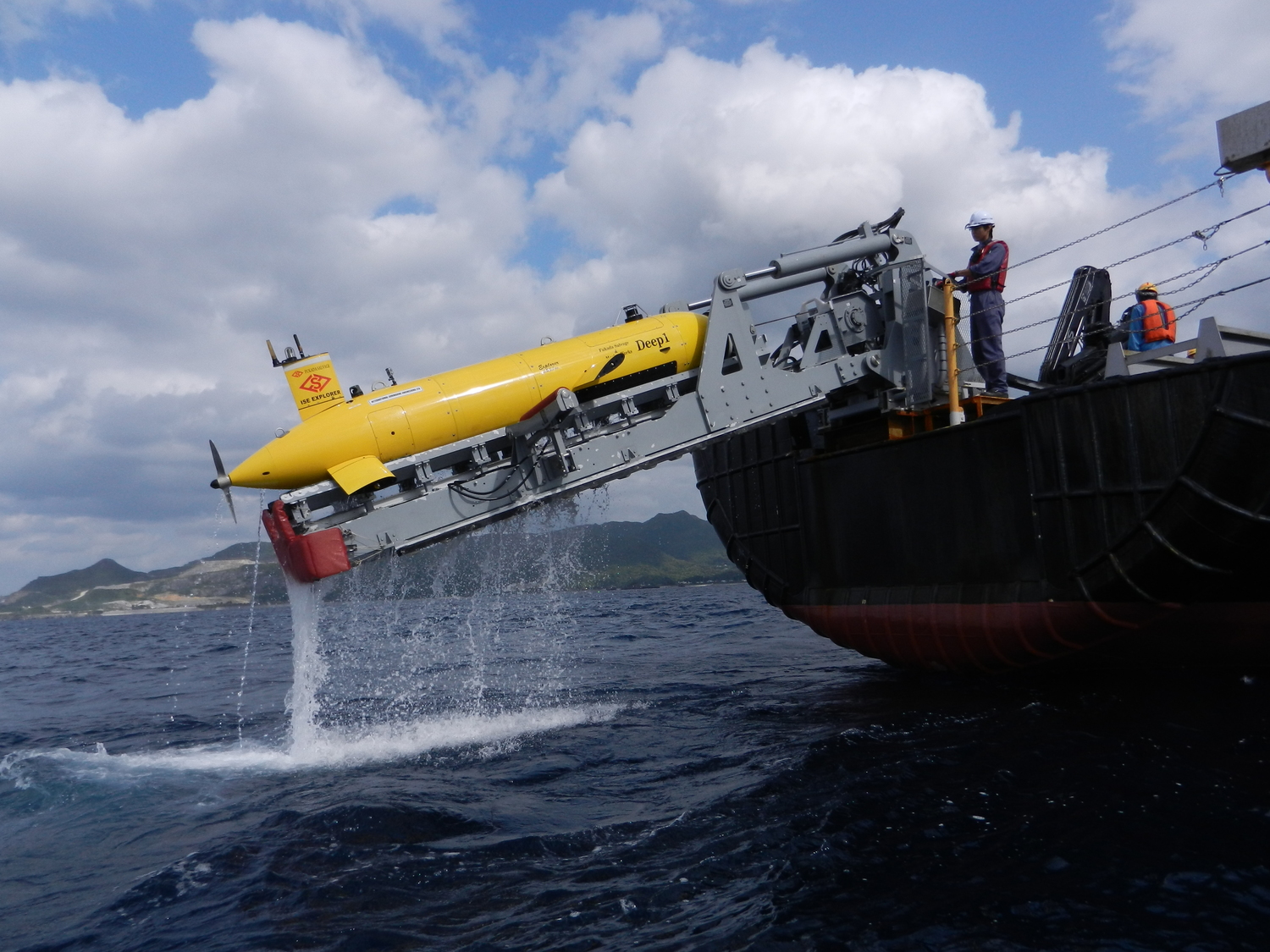
Why is ocean floor mining possible now when it wasn’t 20 years ago? The answer comes down to one word, robots. The world of under water mining is the domain of autonomous drones and human controlled ROVs. Robot submarines are nothing new, they have been around since the 70s and have been used to explore depths of the ocean that are very difficult for humans to get to. UUVs or unmanned underwater vehicles are a little bit newer, they are basically an autonomous version of ROVs. Ocean mining robots have just been invented and share a lot of the technology used in these devices and they look like something straight out of science fiction.
The Cutter
The first deep sea mining project is currently being developed off the coast of Papua New Guinea. The project is called Solwara 1 and is being developed by a Vancouver BC mining company called Nautilus Minerals. Solwara 1 is a copper/gold SMS deposit with estimated copper grades of 7% and gold grades in excess of 20g/t and an average gold grade of 6g/t. The property sits at about 1600m depth.
Nautilus has developed a suite of underwater mining robots and a complete system to mine the precious metal and bring it to shore. There will be the bulk cutter pictured above, an auxiliary and a collection machine. Please take a moment and marvel at these amazing achievements of engineering.
After the robots dig up and collect the ore a custom designed Riser and Lift System (RLS) will bring the material to a giant ship that acts as the mine control center dubbed the Production Support Vessel (PSV). The RLS is basically the world’s most powerful suction dredge. It’s pretty complex, this is the description on the Nautilus Minerals website:
The Riser and Lifting System (RALS) is designed to lift the mineralised material to the Production Support Vessel (PSV) using a Subsea Slurry Lift Pump (SSLP) and a vertical riser system. The seawater/rock is delivered into the SSLP at the base of the riser, where it is pumped to the surface via a gravity tensioned riser suspended from the PSV.
Once aboard the Production Support Vessel the mined slurry will be dewatered and stored until anouther ship comes to take the material on shore for processing. The removed sea water is pumped back down the RALS which adds hydraulic power to the system. Pretty cool stuff! Check out the video below for an visual explanation of how it will all work.
Exploration
Ocean floor prospecting is not a good place to be gold panning or hiking around with a rock hammer. It is also difficult to take usable photos due to poor light and lots of debris in the water. So how do you explore for minerals in the ocean? Geophysics and robots.
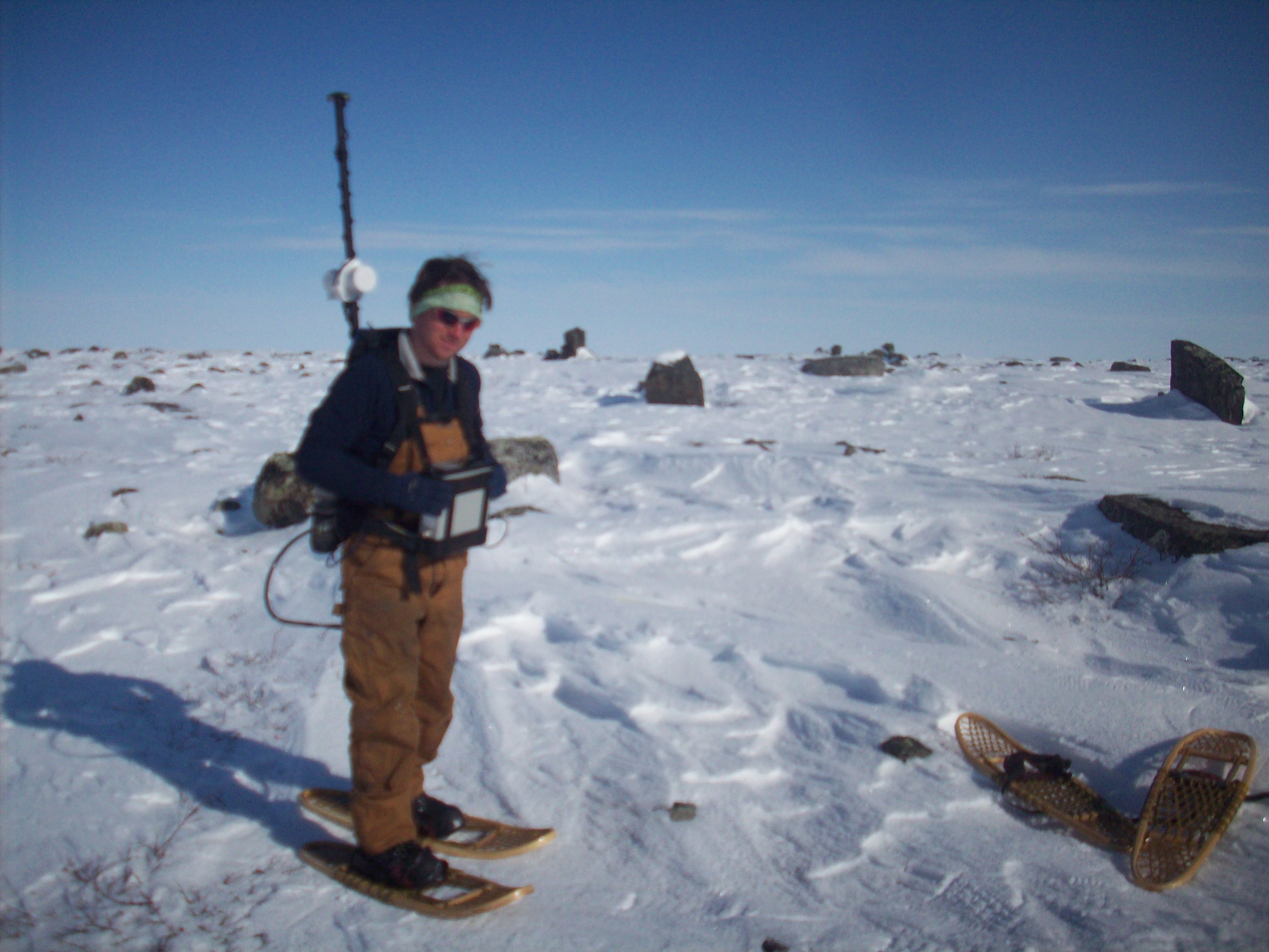
Geophysical exploration is not unique to the ocean. The same techniques are used routinely on land to find every type of mineral deposit. Ocean geophysics is also not new. The main workhorse of mining exploration is magnetometry. Which means mapping changes in earth’s magnetic field using a specialized sensor. The technique was actually developed to detect enemy submarines during World War II. Since then magnetometers and the science behind them have evolved into accurate tools to measure geology.
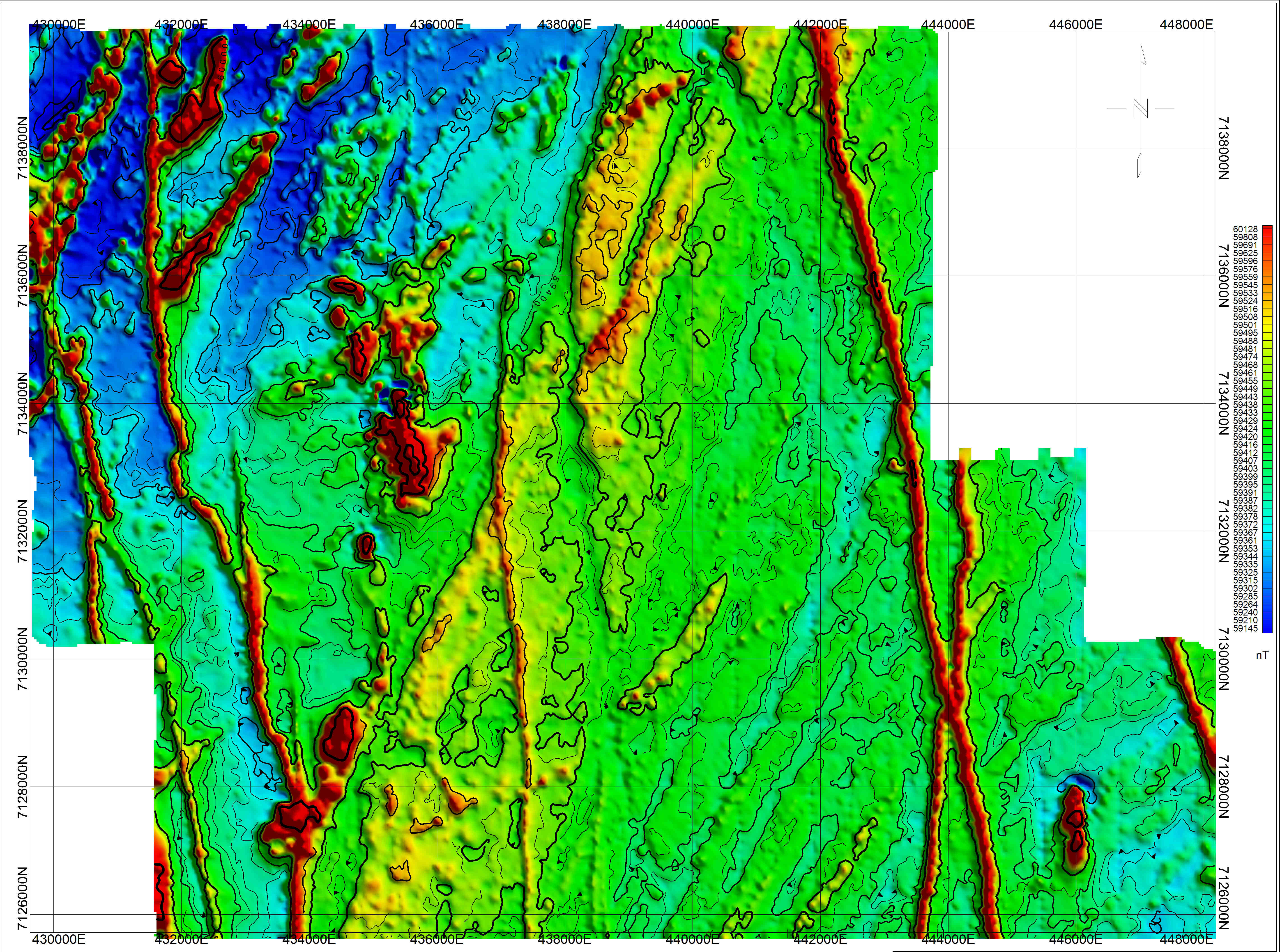
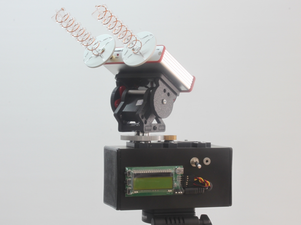
I’m using a proton precession magnetometer in the photo below. There is some sample magnetometer data on the left. Mag maps look similar to a thermal image except the colour scale represents magnetic field changes (measured in nanoTesla) instead of temperature.
Magnetometers are excellent tools for ocean mining exploration. They are not affected by the water and are excellent at detecting metallic anomalies. There are now underwater drones that can collect ocean magnetometer surveys without the need for human intervention.
Autonomous Magnetometer Drone
Other geophysical techniques have been used in ocean mineral exploration. Electomagnetics (EM) techniques are also great tools for exploration under water. EM works in a similar way to magnetometry except that they emit their own source. Conventional metal detectors are actually a small version of an EM system. While mag passively measures Earth’s magnetic field EM measures the difference between a source and received pulse. EM also works great for discovering metallic anomalies and is being incorporated into autonomous drones as well.
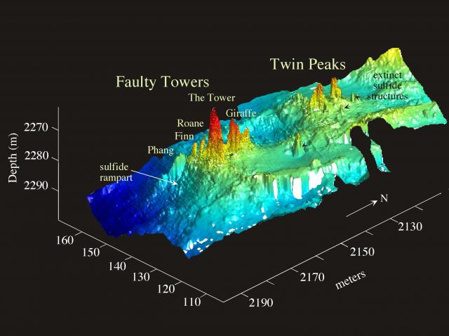
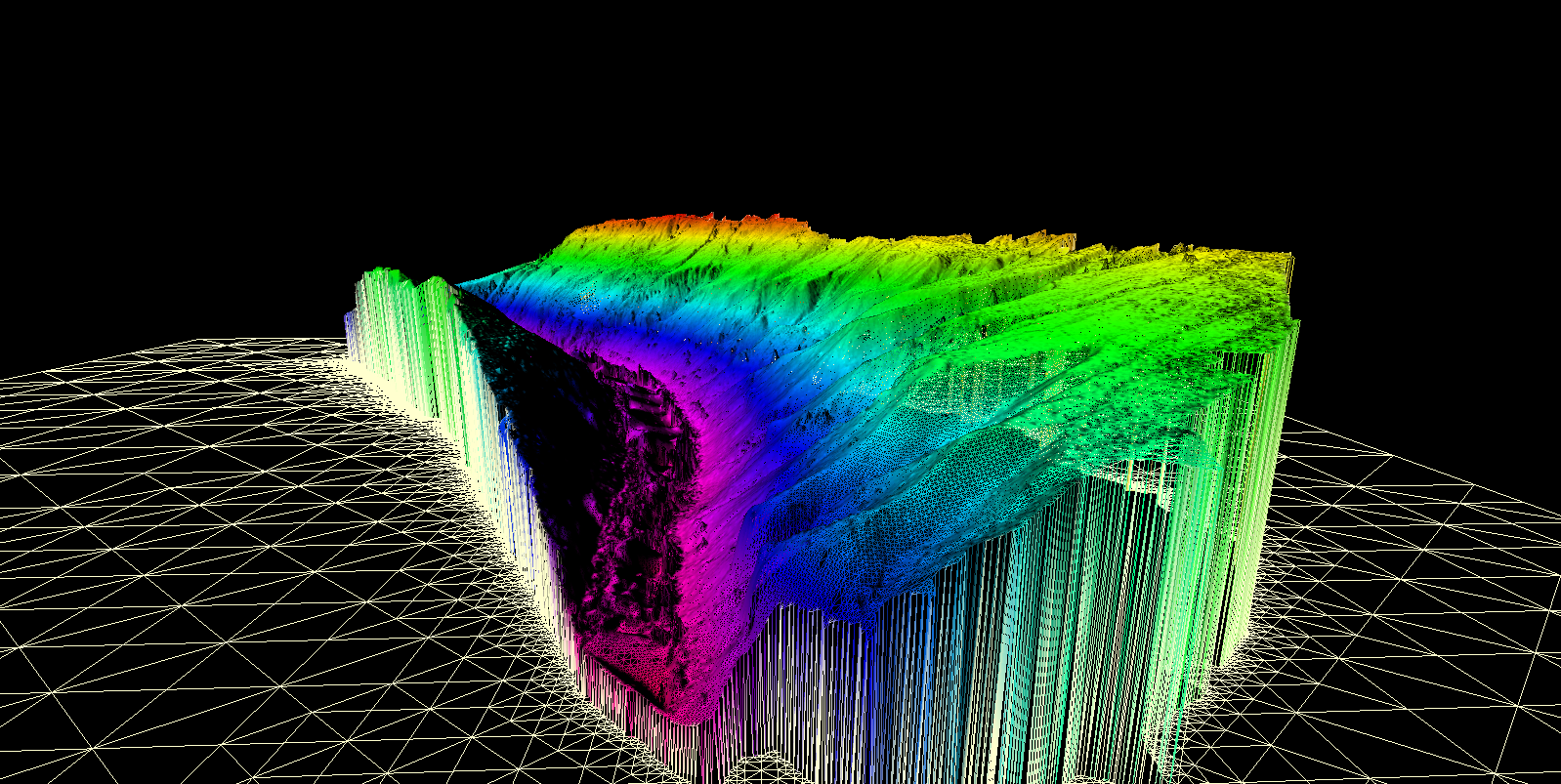
There are other types of ocean geophysics such as seismic refraction which uses a giant air gun to send a sound wave deep into the crust and measures the response on floating hydrophones. Sonar and other forms of bathymetry can provide detailed maps of the ocean floor. Bathymetry techniques can create imagery similar to LiDAR that is used on land.
Sample Bathymetry
Ocean mining is just in its infancy and some really cool technology is being used. Advancements in the robotics have allowed mining and exploration to be completed without a person having into enter the water. As technology advances further we will be able to explore vast areas of the ocean floor and discover immense mineral reserves that are presently unknown. It is estimated that we have only explored about 5% of the ocean floor, who knows what we’ll find down there?
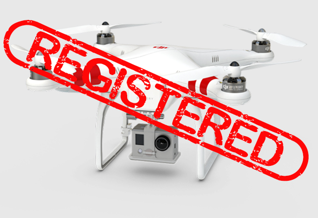
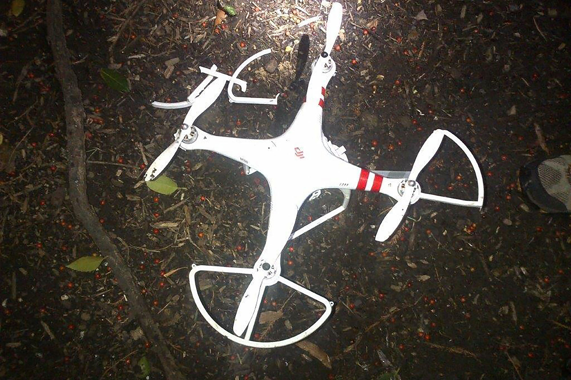
In 2015 the number of drone related incidents sky rocketed. Most of the big news stories of this year were about mishaps related to irresponsible drone users.
With the onslaught of amateur drone operators the US government scrambled to pass legislation that would stem the tide of drone crashes, privacy threats and dangerous flying. There was a great fear that massive numbers of drones would be given as Christmas presents this year dubbed by some at the great “drone invasion”.
The FAA took responsibility for making drone users accountable by issuing a new law that all non-commercial drones need to be registered with the agency. The FAA reasoned that drone users are “aviators”
“Make no mistake: Unmanned aircraft enthusiasts are aviators, and with that title comes a great deal of responsibility,” U.S. Transportation Secretary Anthony Foxx said in a statement released by the FAA. “Registration gives us an opportunity to work with these users to operate their unmanned aircraft safely.”
The FAA drone registration website went live on December 21st which can be seen here: FAA Drone Site. Their guidelines are bit foggy and fail to define what is and isn’t a drone. They do have a list of samples though, FAA Sample Guide. The guide seems to suggest that only drones with autopilot capability (aka actual drones and not R/C models) need to be registered. At the moment the registration system is ambiguous and poorly though out.
The knee jerk reaction from the FAA makes an effort to control the huge number of hobby drones taking flight this year. Much like the long gun registration in Canada the people who are going to break the rules will not register their drones anyway.
Transport Canada jumped on the drone invasion bandwagon as well but fortunately did not enact a poorly thought out registration scheme. They launched a media campaign instead to educate users to follow existing regulations (Transport Canada Announcement)
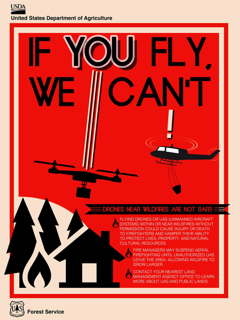
2. Drones interfere with forest fire operations
There were several big news stories this year about drones interfering with forest fire fighting operations in Canada and the United States. This summer was unusually dry and led to an increase in forest fires all over North America. In BC there was a province wide fire ban this summer due to the dry conditions.
One incident near the town of Oliver, BC made headline news across the country (CBC story). Aerial fire suppression crews were hard at work battling a fire that engulfed 1500 hectares and led to the evacuation of over 100 homes. When a small drone was spotted the whole crew of eight helicopters and 6 water bombers was grounded for five hours.
The story spurred negative emotions from many BC residents as the fire fighting effort was desperately needed and the interruption further threatened many homes.
There were several incidents in California this summer too. California had a rough summer with widespread drought and many forest fires. Public reactions were fierce. The county of San Bernadino is offering a $75,000 reward for the identity of drone pilots who interfered with three separate forest fire operations (Reward Story).
3. Hobbyists create weaponized drones
Within the last year two youtube videos from the same drone enthusiast sparked much controversy (CNN Article). In the first video he mounted a handgun to a quadcopter drone and rigged up a remote firing system. The result was pretty intimidating. See the video below.
In December the same enthusiast mounted a custom designed flamethrower to a larger drone and posted anouther video. Once again the controversy spread like wildfire (Popular Science article). The inventor says that the experiments were conducted in a controlled environment with water and fire extinguishers nearby.
Internet users were mostly outraged with many in the drone community lambasting the teenager who created these drone weapons. There were a lot of comments from people fearing their hobby would be banned because of this young man. Others applauded the ingenuity that it took to put these together while some were just plain scared.
It will be interesting to see what hobbyist drone weapons make the news in 2016. Drones were originally developed as weapons systems starting with the German V1 flying bomb in WWII which was essentially a cruise missile. With the long history of weaponized drones we shouldn’t be so surprised when kids are creating them in their backyard.
4. Delivery Drones
Everbody has heard of the Amazon delivery drone by now. News of their plans to develop a 30 minutes or less drone delivery system called Prime Air has been splattered all over the headlines for much of the year (30 minutes or less). Just last month they released a video with former Top Gear presenter Jeremy Clarkson showing a concept of what Prime Air might look like.
Despite the many challenges involved in drone delivery Amazon seems to be taking their plan seriously. They have proposed a special drone delivery only airspace (BBC article). It will be several years at least before the technology and regulations are actually ready for something like this. Take a look at my post on 6 Misconceptions About Drones in 2015 where I explained why this won’t work.
Google (aka Alphabet) and Walmart also filed applications to test drone delivery this year (Walmart Drone Delivery). Futuristic drone delivery remains a tantalizing possibility and will likely remain in the headlines through 2016.
5. Military drone pilots speak out
Military drone strikes were a big story in the news this year. In October a leak was released detailing the United States use of armed drones to murder suspected terrorists and other people they don’t like in the middle east (drone leaks). It had been assumed for years that the US was using drones in countries that it was not supposed to. The leak exposed a massive drone assassination program that was largely unknown
Around the same time stories began to surface of military drone pilots who quit their jobs due to the emotional toll of constantly killing people on the other side of the world (NBC story)
This story from 2012 explains how a US military drone pilot from Montana killed an innocent child. He launched a missile at a building in Afghanistan when a child walked out at the last second before the missile hit. There is a lot of collateral damage in the US drone war campaign. According to this article on Vice News more civilians are killed than suspects (Vice story). Anouther article in the New York Times tells the same story (NY Times).
A huge number of drone pilots are quitting their jobs. More people are quitting than are being trained (Drone Pilots Are Quitting In Record Numbers). The air force in apparently offering huge bonuses to retain qualified operators (NY Post article).
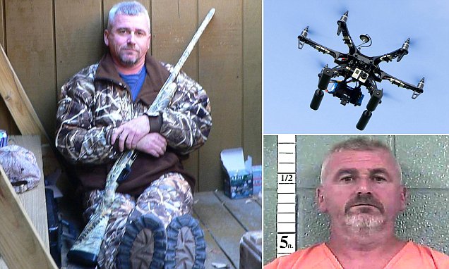
6. Guys shoots down drone and gets away with it
This summer a man from Louiville, Kentucky took down his neighbour’s drone with a shotgun. He claimed that it was spying on his daughters who were sunbathing in his yard. Initially he was charged by police for discharging a firearm in the city. In October a judge ruled that the drone invaded his privacy and therefore he did not break the law in shooting it (Man Shoots Drone)
The drone’s flight data was analyzed after it was shot down. The drone was clearly above 200 feet and had only been in the air for two minutes. It seems obvious that the shooter was acting emotionally and testified that the drone was closer than it was.
There has a been a lot of hype about drones invading privacy. While camera equipped drones do have the capability to spy on people it is up to the operator to act responsibly. There are existing laws regarding voyeurism and trespassing which apply to drones as much as people.
Of course this was not the only drone shooting incident. A New Jersey man also shot a drone with a shotgun he did not have such a sympathetic judge. He was charged with Possession of a Weapon for an Unlawful Purpose and Criminal Mischief (NJ Drone Shooter).
Anouther interesting drone shooter story took place in Modesto, California (Cal Drone Shooter). Again the shooter acted on concerns over privacy. This case was handled by small claims court when the shooter refused to pay for the parts that he damaged. The drone owner won the court case this time.
In some states its OK to shoot drones in others it is not. It seems that shooting drones is a grey area as in the US the legal system (CNN Drone Shooting).
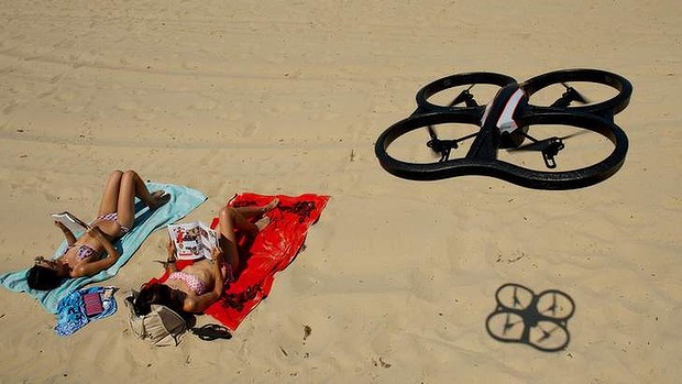
There have been several news stories of drone incidents on beaches. In one case a man was arrested and charged for throwing his T-shirt into the propellers of a drone causing it to crash (T-shirt drone incident).
A particularly interesting incident happened in 2014 at beach in Connecticut (Woman Assults Drone Pilot). A woman was offended that a drone pilot was flying a camera drone over the beach. She attacked the man and was subsequently charged with assault. The man filmed the assault on his cell phone and she now faces up to a year in prison.
It is not against the law to fly or film in a public space. If you are sunbathing on a public beach people can legally take pictures of you with a drone or otherwise.
7. White house drones
2015 saw two white house drone incidents. The first incident happened in January (NBC, Mashable). The drone operator lost control of his DJI phantom and it landed on the grounds of the white house in Washington, DC. The incident was uneventful other than that fact that it landed on government property. Nobody was hurt, no property damage, etc. Although this story reports that the pilot was “drinking and droning” (DUI Droning).
Secret Service Handout Photo
In contrast the the January incident a man was detained for flying a small drone (Parrot Bebop) at the white house (CNN, DailyMail). The area around the white house was put under lock down. Secret Service agents quickly tackled the suspect and detained him. All the surrounding roads have been cleared of people and cordoned off. The pilot (Ryan MacDonald) was arrested and charged with violating a federal order.
The difference in handling of these two incidents is noteworthy. In one case the perpetrator was a government employee who recklessly went to sleep with a drone in the air, and may have been drunk. He actually crashed his drone. In the second incident the man did not crash and was arrested and charged and the white house was put on lockdown.
8. Drones at airports
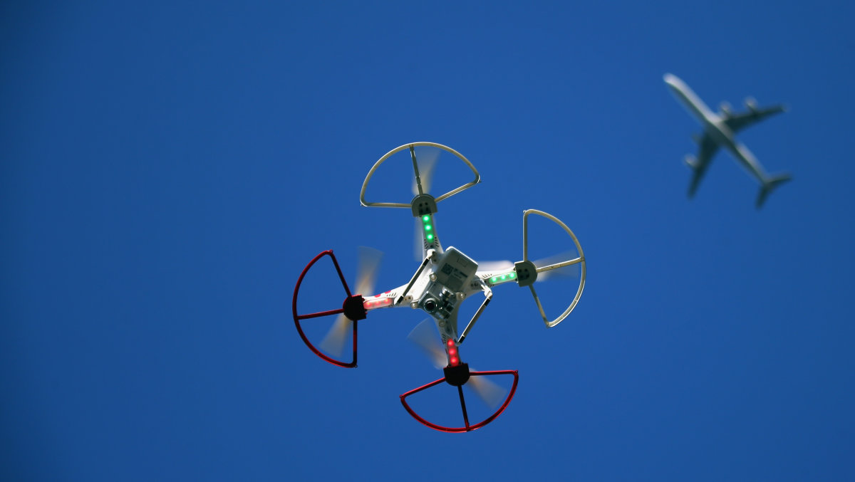
Drone incidents at airports have risen sharply in the last year. It is inevitable that with the huge numbers of drone sales a small percentage of owners will operate in a completely reckless manor.
Once incident in May at New York’s LaGuardia Airport involved a near mid air collision between a drone and a jetliner at 2700 feet (Fox News).
According to this article from the Washington post there were in excess of 700 drone related incidents at airports in the United States in 2015 and the article was written in August.
On July 10, the pilot of an Air Force F-15 Strike Eagle said a small drone came within 50 feet of the fighter jet. Two weeks later, the pilot of a Navy T-45 Goshawk flying near Yuma, Ariz., reported that a drone buzzed 100 feet underneath.
There have been some actual mid-air collisons:
On May 9, the pilot of United Airlines Flight 863 — traveling from San Francisco to Sydney — reported that the Boeing 777 hit a drone at an altitude of 3,000 to 4,000 feet along the California coast.
Vancouver, BC has had several incidents as well (CBC News). There was a high profile incident in October at the international airport and one in August involving a sea plane and a quadcopter (National Post). According to the seaplane pilot the drone came within three meters of his windshield when he was landing.
These kind of incidents have been spreading rapidly and in each case you have to wonder what the person was thinking. There are several awareness programs in place now but do you really need someone to tell you that its a stupid idea to fly a drone at an airport?
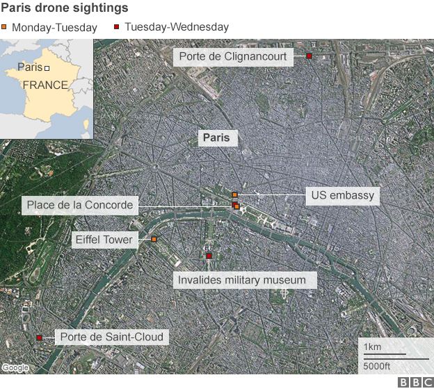
9. Drones over Paris
In February drones were spotted flying over several Paris landmarks including the Eiffel Tower, and the US embassy. The drones were spotted two nights in a row presumably taking photos or video of the landmarks. Flying a drone at night is illegal in France and drone flights in central Paris are also banned.
The story was huge news despite how little was known. News agencies in Europe reported the facts and that the pilots or drones had not been located (BBC News). Here is an excerpt from a BBC article.
The security threat from these drones is minimal. Bird’s-eye images of Paris landmarks are available online in far higher quality than anything these devices could produce. And small, shop-bought drones are not strong enough to deliver a significant payload of explosives.
News in the United States took the story to a whole different level. The CNN video below has “TERROR IN THE SKIES” as the headline for their report. With no information to go on CNN decided to scare the pants off American viewers.
A week later three Al Jazeera journalists were detained as suspects (Al Jazeera Story). The reporters were in fact operating their own drone as part of their coverage of the mystery drone story. They were detained for 19 hours and questioned.
The actual perpetrators were never found. The Paris drone flights remain a mystery. They were likely tourists using their toy drones to capture aerial video of landmarks.
10. FAA grants over 1000 permits
In August of 2015 the FAA announced that it had issued over 1000 exemptions for commercial drone operation (Fortune Article). Through much of the year they were issuing permits at a rate of 50 per week. The FAA was mandated by congress to come up with commercial drone rules by 2015. They dragged their feet and still only have an interim measure called a section 333 exemption.
Commercial drone activity is illegal in the United States and the permit grants an exemption to the law. The process is similar to what Transport Canada has been doing for a decade. Without a permit there is no commercial work. What this story really means is that the United States is finally able to have a domestic commercial drone service industry. Prior to 2015 only a small number of permits were issued giving the holders a virtual monopoly on drone services. With the increase in permits there is beginning to be some competition in the market.
Section 333 exemptions are not easy to get. There is a paperwork intensive application process and all the criteria need to be met. The FAA is moving towards an actual licencing system instead of the patchwork of regulation that they are now using.
Runner Up News Story:
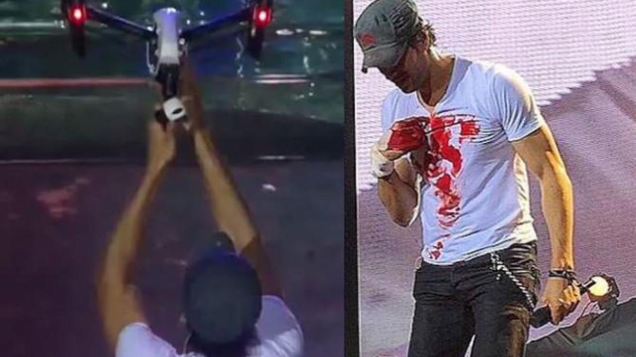
Enrique Iglesias Slices Fingers on Drone
During a concert in Tijuana, Mexico Enrique Iglesias grabbed a drone out of the air and sliced his fingers on the propeller. This story made headlines in May of 2015 (DailyMail Story).
The drone was used to get crowd footage during the concert. Enrique grabbed the drone to get a POV perspective. He continued performing for 30 minutes and was airlifted to a hospital after the show. He was bleeding the whole time. You have to respect the guy for continuing the show despite some fairly serious bleeding.
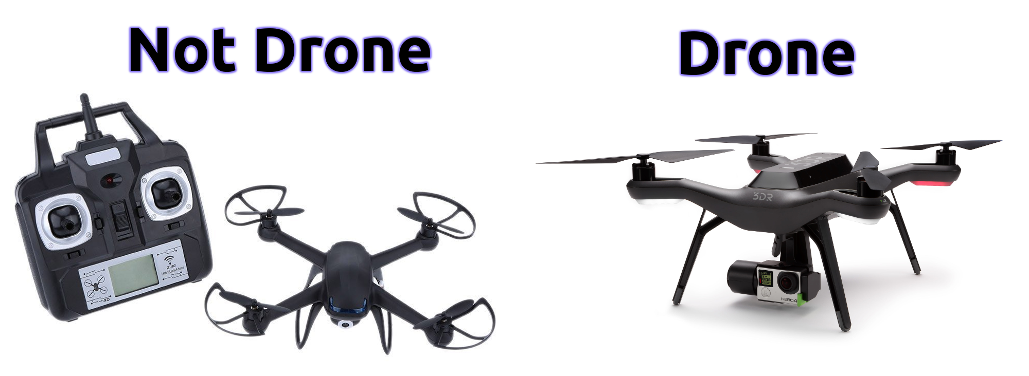
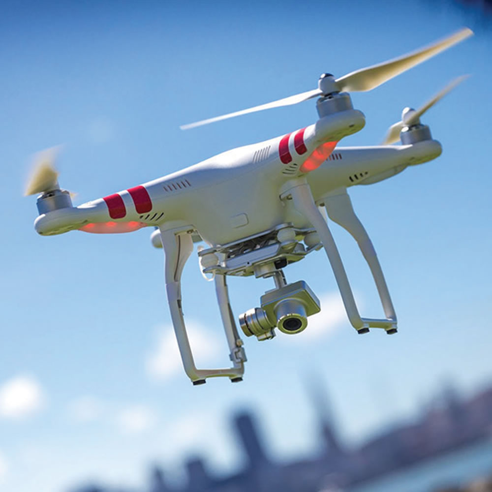
The rise in popularity of consumer drones has led to a considerable amount of confusion. The word drone has been misused by the media and manufacturers attempting to capitalize on the excitement that surrounds everything “drone”. A drone is a robot that has the ability to operate autonomously without direct control from a human operator. “Drone” usually refers to unmanned aircraft which are also called UAVs (more on that later). There are other types of drones too such as boats, submarines and ground based robots. For an aircraft to be considered a drone it must have an autopilot and have the ability to fly without user input. Many of the “drones” on the market right now do not meet that criteria. For example this is not a drone, Flymemo DM007 but it is marketed as one. This one is a drone 3DR Solo Drone Quadcopter.
There are similarities to real quadcopter drones though. The DJI phantom is a real drone, the difference being that it has an autopilot and can operate a flight pattern autonomously. Likewise “racing drones” are not drones at all. They are totally cool though and look like a lot of fun.
Quadcopters have been around for a long time and offer a stable platform compared to conventional R/C helicopters. The correct name for these non-drones is R/C quadcopter. Adding a camera does not make an R/C aircraft a drone either.
#2 You can’t just fly wherever you want
Commercial and Hobby use of drones comes with regulations. Like most laws it is the responsibility of the operator to learn and obey the regulations. In Canada the regulations are in a state of flux so it is important to keep up to date with the changes. Likewise in the United States new rules are currently being developed to register all recreational drones.
Canadian recreational users can be fined up to $3000 for an infraction of the recreational rules. Commercial operators are subject to fines up to $25,000 for flying without a permit or exemption. Any damage caused by reckless drone usage can also be charged back to the owner. Other laws also apply such as voyeurism and trespassing. RCMP have been investigating unauthorized use and have issued fines to non-compliant operators (CTV article).
At the present time both Canada and the United States do not have a licencing system for commercial drone operations. In both countries the existing laws consider commercial drone activity illegal and therefore an exemption or permit is required. In Canada this is called an SFOC or a “Section 333 Exemption” in the US. The Canadian laws are further ahead as there is somwhat of a streamlined system to apply with a clear set of criteria. Exemptions have been made for small drones provided that they have insurance and operate at a safe distance from airports, and buildings. This link has flow chart for the current exemptions, TC Exemptions.
Reckless drone incidents have risen sharply in the last two years with the increase in drone sales. There was an incident this summer where a recreational drone interfered with a forest fire fighting operation in Southern BC (news article). A disturbing amount of drones have been spotted at airports interfering with commercial air traffic as well.
#3 Confusing Acronyms
Following up on misconception #1 there are a lot of confusing acronyms and terms for drones and drone-like aircraft. The “proper” name for drones is actually UAVs or unmanned aerial vehicles. Some people will say UAS or unmanned aerial systems. These terms are a matter of debate in academic, military and regulatory circles. Drone, UAV and UAS essentially mean the same thing.
The terminology gets a little foggy when you start talking about RPVs which stands for remotely piloted vehicle. Many of the large military drones fall into the RPV class. The difference is that they are actively piloted by a human although the human can be hundreds or in some cases thousands of miles away. RPV’s are essentially big expensive R/C planes. R/C is another acronym that is part of the mix. As discussed in #1 R/C stands for radio control and refers to the hobby planes, helicopters and multirotors that are literally controlled by radio transmitters.
Modern drones developed from R/C aircraft and have many of the same components. One more acronym that is related to drones is FPV which stands for first person view. That is the technique used to fly R/C aircraft using a live video feed via radio link and video goggles. FPV is pretty cool stuff, check out the video below (be advised that they are likely breaking the law).
#4 Drones will not be delivering packages anytime soon
There has been a lot media coverage recently about drone delivery systems. Amazon has been leading the charge with a media frenzy around what they call “Amazon Prime Air”. Just this week they put out a promotional video hosted by former Top Gear star Jeremy Clarkson. See the video below,
It looks cool, even plausible, but there are several major road blocks that need to be dealt with before drones will be landing in your back yard. First the drones require a system called Sense and Avoid. This is arguably the holy grail of modern drone development. Sense and avoid means that the drone can avoid collisions with unplanned obstacles, people and vehicles using onboard sensors and real time decision making. Great strides have been made in the last two years in this field but it will be a while before it is ready for the real world. Check out this ground breaking video from researchers at MIT,
In addition to sense and avoid systems delivery drones will also have to be reliable in all weather conditions. There are very few drones today that are capable of flying in rain, strong wind or at night. There are other reliability issues that need to be addressed such as battery life, and battery consistency. Not to mention dealing with militant anti-drone activists or simply kids that might throw plastic bags or rocks at delivery drones. Apparently it is legal to shoot down other people’s drones in the United States (see this article).
The last hurdle that needs to be cleared is regulation. Amazon, Google and Walmart have all been lobbying for a designated altitude to be used for delivery drones above cities. The proposal sounds like something out of a science fiction novel, and may one day part of the solution but it will take a long time. Currently drones are not prohibited within 9km (Can) or 5 miles (US) from an airport which is where the majority of customers live.
Drone delivery is not a new concept. In remote regions of Africa experiments are underway to deliver live organs and medicine between villages. Check out this TED talk on the subject. In rural Africa there is virtually nothing for the drone to hit, no conflicting traffic and so on. In areas like that drone delivery can already take place. Drone delivery services will be available in major cities one day but with today’s technology and regulatory climate it is nothing more than a publicity stunt.
#5 Most of the military drones are not killing machines
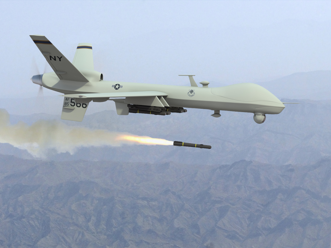
A widely held misconception about drones is that the US military drones are all weaponized killing machines. Coverage in the press gravitates towards the very controversial remote killing machines that the military certainly does posses. They have several models of weaponized drone, the main drone strike tool is the General Atomics MQ-9 Reaper. The Reaper is a bigger, more powerful version of the Predator with the addition of weapons payloads. They also have F-16 fighter jets converted to drones and unmanned bombers. The Tomahawk cruise missiles which were made famous in Desert Storm are also basically kamikaze drones.
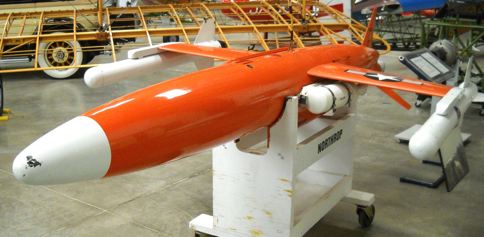
1970s Target Drone
The first drone weapon was developed by the Nazis in WWII. It was called the V-1 Flying Bomb and was essentially an early cruise missile. The US has a long history of drone useage beginning after WWII with unmanned target drones. Miltiary forces all over the world routinely use target drones to for target practice every day. It is mind boggling that they build simplified drones that cost between $10,000 and $40,000 just to shoot at and destroy. These non-weaponized drones are used daily.
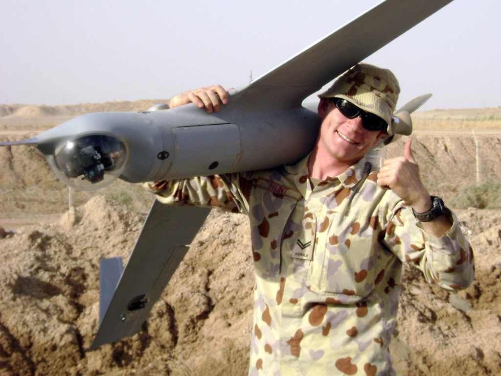
The drone age really took off with reliable photography drones in the 1990s. The most successful drone to date is the Insitu ScanEagle. The ScanEagle was originally developed in Oregon by Insitu to map tuna schools. They have been deployed in US military operations since 2004 and all they do is take pictures. The AeroVironment RQ-11 Raven is a small hand launced photography drone that can be rapidly deployed to take aerial photos. The Shadow, Blackjack and RQ-170 Sentinel are all photography drones as well. The Canadian military uses the Israeli made Heron UAV and the ScanEagle, we do not have any weaponized drones.
Insitu Scan Eagle
The Predator and Global Hawk are extremely successful long range, high altitude drones that collect aerial imagery and do not have weapons capability. I am not advocating in any way the use of drones for murder but the media promotes stories on the controversial killing drones in the headlines. This disproportionate reporting give the impression that all military drones are killing machines. In reality there are only a handful of killer drones while the overwhelming majority take photos and collect remote sensing data.
#6 Drones will not crash if their radio is jammed or lost
There has been some press lately about using radio jammers to knock out drones. There are even some start up companies marketing radio jammer guns. They look like some kind of futuristic weapons.
Drone radio jammer made to look like a weapon
Radio jammers work by overloading a signal with random noise. The jammers that are being designed for drones use directional antennas and focus on the the frequencies often used by drones (2.4 – 5.8 GHz). Some drones operate on different frequencies such as 900 MHz which would require different antennas.
If tuned to the correct frequency range a jammer can definitely disrupt a drone’s radio link. That will not cause it to crash though. Just about every drone in operation today has a set of failsafe programmed features. One of the most important is a radio signal loss failsafe. What that means is that the drone is programmed to follow a procedure when signal is lost. Typically the drone will return to its take off point and hover or circle in the air until signal can be re-gained.
Drone radio jammer
Drone’s can lose signal for a lot of reasons and it has happened to me on numerous occasions. They also have failsafe procedures for loss of GPS signal, battey power, etc. The definition of drones comes into play again here. Radio controlled aircraft such as R/C quadcopeters which are often mis-labelled as drones will crash when signal is lost. That is true of any non-autonomous R/C aircraft. Without receiving commands from the pilot they will all crash. So radio jammers are effective on R/C devices.
In recent months momentum is building for drone radio jammers to be installed in airports and other sensitive areas where reckless drone activity could be a nuisance. First of all they would not actually be effective against drones and second the jammers would overlap with commonly used aviation frequencies. So that is never going to happen. If commercial jet flights are concerned about having a cell phone powered up during flight how would they like high powered radio jammers operating in the vicinity?
Unmanned Aerial Vehicles (UAVs) are in the process of changing many industries. Before UAV technology matured into a safe, reliable and low cost system aerial data was acquired by full size human piloted aircraft and was very expensive. With today’s drones aerial data is cheaper, quicker and more creative than ever before.
The mining industry stands to benefit greatly from new advances in aerial data acquisition. In many cases drones are already being used in mining and in the coming years will be almost ubiquitous.
Drones offer huge advantages in every part of the mining life cycle including Exploration, Planning/Permitting, Mining Operations and Reclamation.
Exploration
Mineral properties are often in remote areas where existing maps are either non-existent or of poor resolution. In early stage exploration it is beneficial to have a quick overview of the prospect area. In the past this would have been acquired by a conventional aerial photography company. This would come with a large price tag. As a result aerial mapping surveys would not be conducted until later stages of exploration.
Today a drone can do a better job for less money. Drones can map an area in high resolution in less than a day, usually a couple of hours. The cameras on today’s drones have benefited from advancements in small high resolution sensors. Miniaturization of other components such as GPS and computer boards has also contributed to the modern drone. Due to the unmanned nature of a drone it can fly close to the ground which allows unparalleled image resolution. Conventional aerial survey aircraft require camera’s with extremely high resolution (80mp and up) because they fly at elevations of 2000-5000 ft above the survey area. Drones can fly at 250 ft with a 16mp camera and get better data.
Satellite imagery has come a long way as well but does not come close to the quality of drone data and the cost is still prohibitive. The best satellite data today is provided by the WorldView-3 satellite at 31cm/px. Drones can produce 4.0cm/px or better. You can forget about Google Earth, their resolution is no better than 65cm/px.
Early stage exploration projects can now get a rapid aerial image mosaic produced by a drone for a couple thousand dollars. Where a conventional aircraft would produce an inferior product for about ten times the cost. This cost advantage allows imagery to be collected very early in the exploration process when it can be of the most benefit.
In addition to aerial imagery the same drone data can be used to produce accurate topographical maps and GIS data in remote areas. Topo mapping was previously produced by ground surveyors with an RTK/GPS rover. You would have to pay a survey crew to walk the entire property and collect GPS points to be used in a map. Mapping drones can do this today without the need for any ground control points at all!
The combination of low cost aerial imagery and terrain data allow modern explorers to have a close up view of any property in 3D. Having this capability in early stage exploration aids significantly in project planning. Drones can provide support for mineral exploration in the following areas:
Terrain Assessment
Geomorphology
Outcrop Detection
Wildlife and Environmental Assessment
Drill, Showing and Equipment Location
Up to date imagery of the property
Remote sensing has huge applications in prospecting as well. In the years to come sensors such as infrared, hyper/multispectral cameras and LiDAR will improve upon existing satellite based techniques to map underground river systems and directly identify mineral bearing outcrops.
Aerial geophysics is making its way into drones too. I was involved in the development of a large scale drone from 2011-2013 designed to conduct long range aerial magnetometer surveys. It was a great advancement but sadly the company suffered from poor management. A few other companies have developed magnetometer drones in recent years too. Drone geophysics has the same advantages over conventional aircraft such as low acquisition cost and rapid deployment.
Prototype Long Range Geophysics Drone in 2012
Planning/Permitting
In the development stage drones offer unparalleled advantages to mining companies. One of the biggest hurdles in developing a mine is environmental permitting. Low cost drone imagery can map a mining property in incredible detail. Aerial photos allow mine planners to easily locate and map:
Trees/vegetation
Streams, Rivers and Lakes
Wildlife Counts
Existing Roads, infrastructure
Before/After Ground Disturbance
Having aerial photos of an area before mining takes place will give an honest account of what the land was like when it comes to reclamation. Wildlife counts and mapping of the ecosystem are crucial in development of environmental impact assessments.
Prototype LiDAR on drone
Wing-tip magnetometer on a drone
Three dimensional mapping has been used in mine development for decades. This data is relied on by mine planners to develop the mine itself, roads, tailings ponds, electrical infrastructure, and pretty much everything. The main tool used is LiDAR which is a laser scanner that produces a high resolution 3D model. Drones can produce the same data for less money. LiDAR sensors are just starting to be installed on drones. Photogrammetry can produce the same quality of model as LiDAR as well but cannot separate trees from ground as effectively.
Photogrammetry and LiDAR data are used for:
Mine pit development
Tailings pond design
Cost effective power line routes
Development of access roads
Geological Assessment
Mining Operations
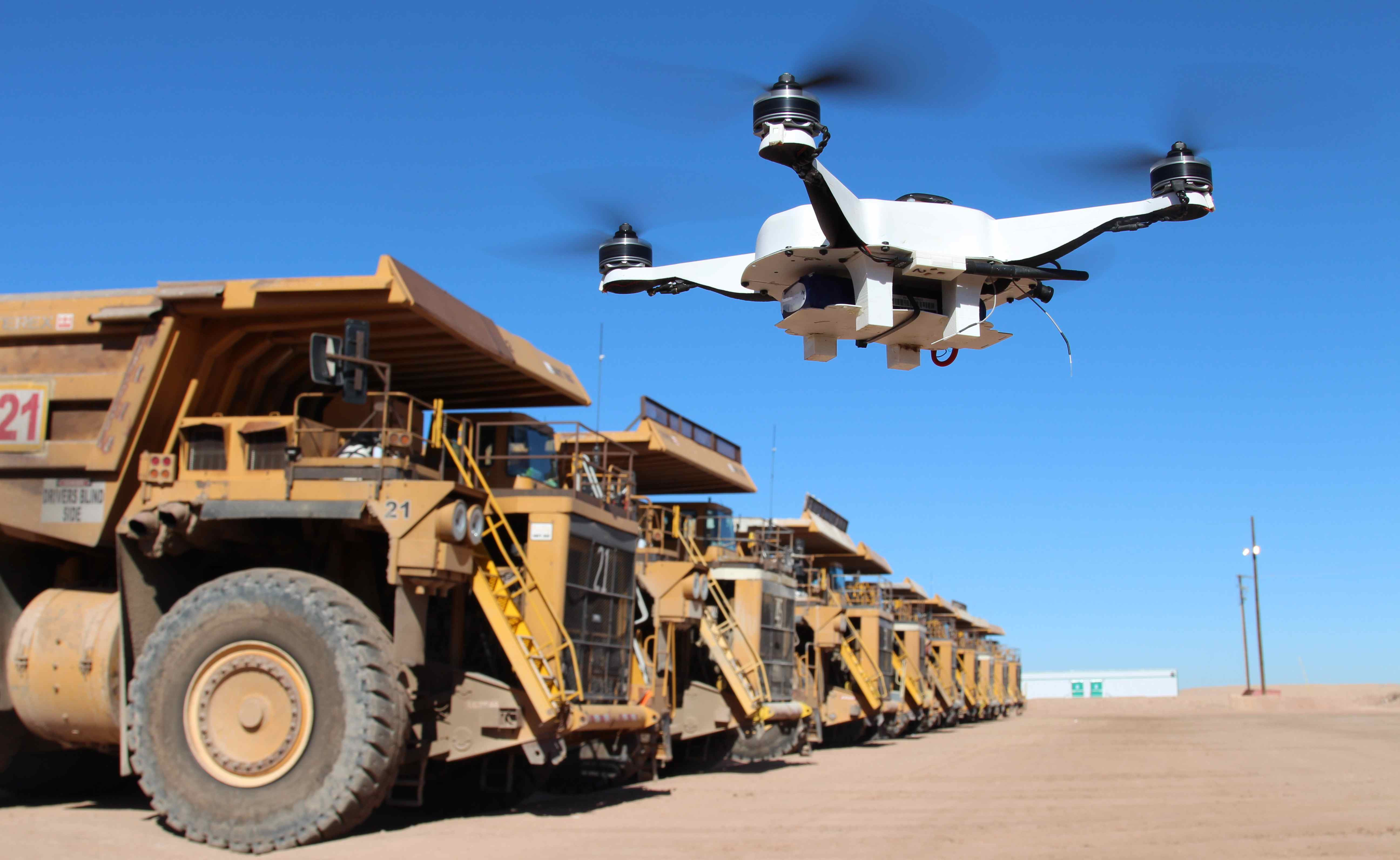
Ore Pile Volumetrics
In the operation/mining phase drones have a lot to offer. One of the most widely used applications of drones in mining today in in stockpile volumetrics. That is the 3D volume calculation of pile of waste rock or ore piles. Having volumetric surveys completed at regular intervals will give an accurate measurement of how much material has been moved in that time. This is important for many reasons. Historically stock pile measurements have been conducted by ground surveyors with GPS rovers. Many mines are still operating this way today. Drone can do the same job without the need to pay for survey crews or to put people in a potentially dangerous situation.
Drones can provide detailed modelling and imagery of pit walls and slope stability. Fixed-wing and multirotor inspection drones can get a close up, detailed image of potential points of failure in a pit wall. Smaller multirotor drones are starting to be used to map underground mines too, offering the same advantages.
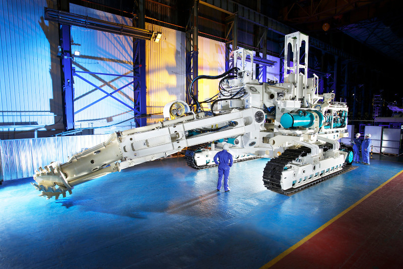
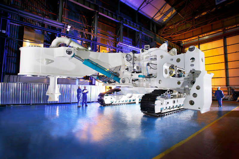
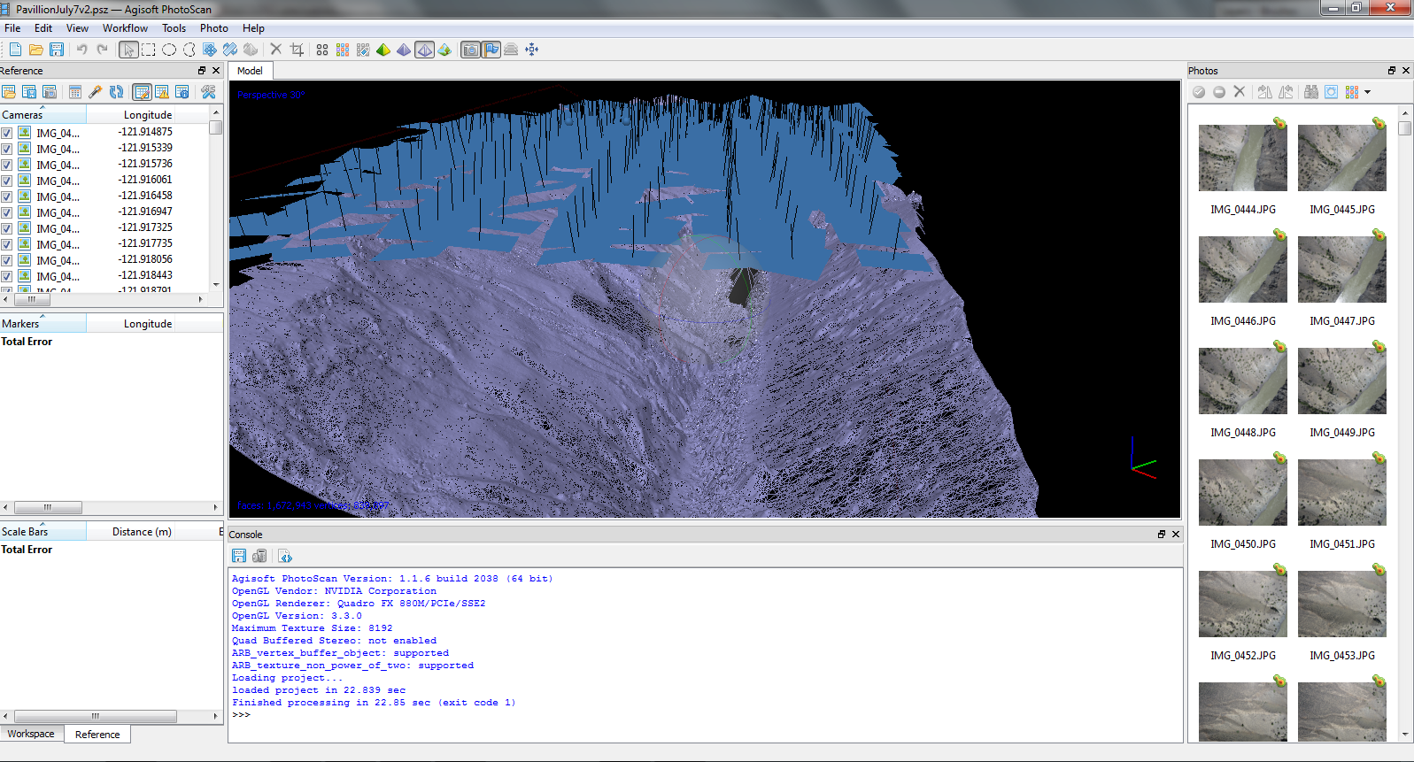
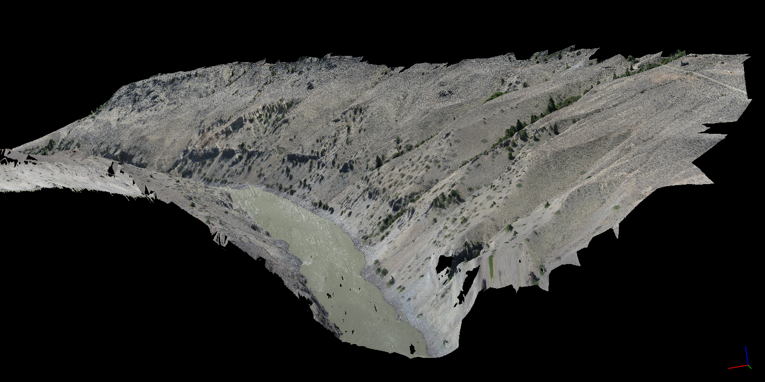
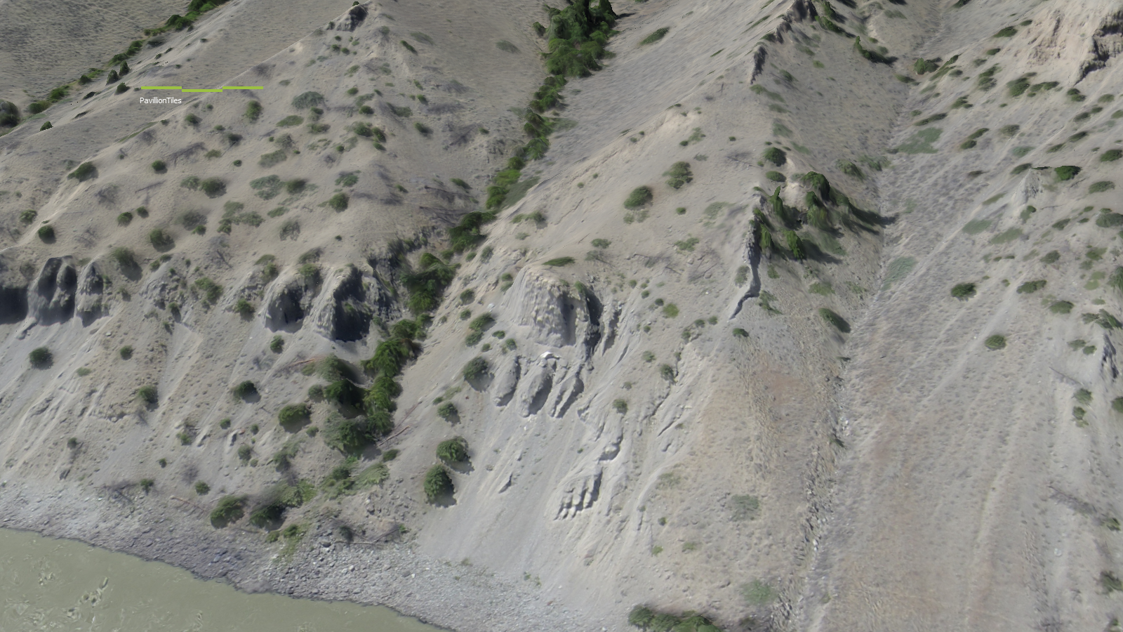
3D pit models can be done for a surprisingly low cost. West Coast Placer conducted a pit mapping survey for a coal mine this summer and the results were amazing. Check out the above video for a sample. Mine engineers were able to use our data in their mine planning software (Minesight) to aid in development of the mine. Like stockpile volumetrics pit mapping will provide a useful record of mine activity when repeated at a regular interval. The low cost of drone data makes repeated surveys feasible on any budget.
Environmental monitoring is a part of active mines too. As discussed drone aerial data offers huge advantages to environmental monitoring teams. In the event of an accident or disaster drones can provide a detailed image of the event as it happens. When the Mount Polley mine near Likely, BC had their tailing dam disaster in 2014 drones were used to map the extent of the damage. The same drone company provided updates as the clean up progressed.
Reclamation
During reclamation it is required to show before and after imagery to prove that a mining company is upholding their obligations. Accurate three dimensional data acquired by UAVs helps mines return the terrain of a mine as close as possible to its original state. Periodic surveys can show the progress as an ecosystem returns to it’s pre-mining conditions.
Currently in 2015 drones are just beginning to be used in mining. There are a few intrepid drone service providers like West Coast Placer offering amazing products for prices that are 1/4 or less of what traditional aircraft would cost. In the coming years we are going to see more and more drones operating on mine sites. It will be standard equipment for explorers, miners and environmental teams in the not too distant future.
Check out our drones page to see the drone services provided by WestCoastPlacer.
Five years ago you rarely heard the word “drone”. When you did it brought up images of military air strikes and futuristic sci-fi movies. In 2015 drones have become commonplace and are starting to be used in many industries. A drone provides many advantages over traditional fixed wing data collection and the low cost makes it a practical solution to many problems. Hobbyists are also quickly getting into the game due to dropping prices. It is amazing how many people will drop $1000 or more on these high tech gadgets.
Drones, also called Unmanned Aerial Vehicles (UAVs), are flying robots that are able to execute a task autonomously. They come in several different forms but they all have the same core components. The four critical drone components are Autopilot, Propulsion, Sensors, Payload.
The Autopilot
The autopilot is the essence of what makes a drone. In order for an aircraft to be called a drone it must have the capability to fly without human intervention. The usage of the word drone has been misconstrued in recent years. Just because an R/C aircraft has four rotors and a camera does not make it a drone, it muse have autonomous flight capabilities. Autopilots are sort of the brain of a drone. They monitor all the information coming in from the sensors and send signals to the control mechanisms based on their programming.
The autopilot software functions much like a thermostat. For example if the drone’s alitutde is set at a certain number the autopilot will contol the aircraft to maintain that number. If the drone rises higher the autopilot will adjust the controls so that the drone descends, if its too low it will set the controls to climb. The autopilot operates in this way for hundreds of different parameters such as airspeed, altitude, GPS position, attitude (3D orientation), and many more.
The use of autopilots goes back to at least the late 1940s when experimental aircraft were able to operate completely by computer control. Modern commercial airliners actually employ autopilots that can control the aircraft from takeoff to landing, the only thing they can’t do is taxi. Every time you fly on a commercial jet you are riding a large autonomous robot.
For a flight to be successful the autopilot must have the parameters for the flight such as flight path, altitude, flight restrictions and settings stored in its memory before takeoff. Once in flight the autopilot will use the preprogrammed information to follow a flight pattern and land at a predetermined location. Watching an autonomous drone in action is quite an experience, they can give the impression that they are thinking for themselves.
Pitot Tube
The Sensors
Sensors on a drone connect it to the real world. They perform the functions that the eyes, ears, nose and other senses do in a human. A drone can only know what the sensors tell the autopilot, much a like a human’s concept of the world is based on what we can see, smell, hear and touch. For example a drone will not have any idea it is heading directly for a tree unless it is equipped with an obstacle avoidance system. The same is true of hitting the ground or a person who walked in front of the aircraft. The pitot/static system is used to measure the current airspeed and altitude. This sensor measures air pressure from a forward facing tube, as air speed increases so does the pressure. The static tube measures the change in barometric pressure which decreases with altitude. The pitot system also measures the wind speed by comparing the airspeed to the GPS speed.
Most drones have a GPS system which is the basis for autonomous flight plans, and in the case of very accurate GPS systems altitude can be measured. Drones also have a 3 axis accelerometer which monitors the aircraft’s orientation relative to the horizon. Accelerometers are also used in smart phones, they are the device that senses when you shake or tilt the phone. More complex drones have fancy inertial measurement units (IMUs) which use gyroscopes and other methods. Drones have servos which monitor and adjust the position of control surfaces such as ailerons, or rudders. Servos are electric motors that are calibrated to precisely place their control arm. There are countless optional sensors which can add new capabilities to a drone. Some optional sensors are altitude lasers or radar, trasnponders, voltage sensors, magnetic compass, and obstacle avoidance sensors.
The Propulsion System
There are a variety of propulsion techniques in use in drones today. The majority of drones use electric motors. The typical drone that most people would think of is a multirotor helicopter. These use electric motors with a propeller on each. Thrust of each motor is carefully controlled to maintain the correct speed, altitude and attitude of the drone. Small fixed wing drones often use electric motors too although usually just one. They are typically propeller driven as well and they work together with the control surfaces to make a flight successful. Electric motors rely on battery power and can fly as long as the batteries hold a charge
Gas or heavy fuel motors are used on larger fixed wing drones and are still usually propeller driven. There are a few drones out there using jet and turboprop engines such as the Reaper (armed version of Predator). Rocket engines have been used for decades in target drones. Targets were one of the first uses of drones by the military. Its hard to believe but military forces around the world routinely shoot target drones which cost $20,000 and up each. Gas or rocket drones run on a fuel source and their flight duration depends on how long the fuel lasts. Gas drones also have batteries for their electric components and some of them have an on board generator.
I was part of the team that developed this drone
The Payload
Payload is often the area where the most development work is focused. After all these robots are flying for a purpose. The most common payload is some form of a camera. The majority of drones out there are either taking photos or video. Most small drones consist of a multirotor with a GoPro camera on a gimbal. Mapping drones like the one used by WestCoastPlacer have a down facing high resolution camera that is triggered by the autopilot. Mapping drones also record the GPS position and aircraft orientation with each photo for use in processing. Different kinds of cameras can be used such as infrared, multispectral and hyperspectral.
Camera mounts that I designed in 2012
LiDAR laser scanners are starting to be mounted on drones too. It has taken a long time to miniaturize LiDAR sensors to the point that a small-medium sized drone can carry one. Drone LiDAR sensors to date have not been able to provide classification so that a bare earth model can be produced.
Magnetometers are being mounted on drones too (Pioneer Exploration, GEM). These are geophysical sensors used to measure changes in Earth’s magnetic field. This sort of data is used in mineral exploration and location of land mines and submarines. There are many more payloads out there such as air quality sensors or wifi internet repeaters.
The Communication System
Another important component of a drone is the communication system. It is technically possible to operate a drone without real time communication since they fly autonomously however it is irresponsible and in most places illegal to do so. An unmanned aerial system will include some form or radio communication with the operator. The operator will have a radio link hooked up to a field computer with base station software to program the drone and monitor in during flight. On board the drone will be some form of two way radio system which will transmit data to the base station as well as allow the operator to issue commands. Telemetry data received from the drone allows the operator to monitor the flight and make sure that everything is working properly. Examples of telemetry data are things like airspeed, battery health or fuel level, position and orientation.
Typical radio frequencies that are used are 900 Mhz, 2.4 GHz or 5 Ghz. Range of a standard system is 5-10 km. Factors that affect radio range are frequency, transmit power, antenna choice and terrain. Some drone operators have had great success using directional and helical antennas. Some helical antenna systems are capable of communicating up to 100km away. Cheaper drones communicate via WiFi (also a form of radio) to a smartphone or tablet. WiFi range is limited to several hundred meters but can be extended with directional antennas.
Helical Directional Antenna with Tracker
Cellular modems are used in some drones utilizing LTE/GSM networks and can greatly increase the operating range. Essentially you can fly anywhere there is cell coverage. Satellite systems are also used which operate on a satellite phone network such as Iridium. Theses communication systems have virtually no limit on range but have slow throughput and expensive by the minute billing.
All the individual parts of drones work together to execute a flight and achieve the goal of the operator. New uses are being discovered for this technology every day. The low price and superior data quality make the UAV a powerful tool for collecting aerial data. In the coming years we are going to see drones used in more and more industries. It just makes sense.
Check out our drones page to see the drone services provided by WestCoastPlacer.
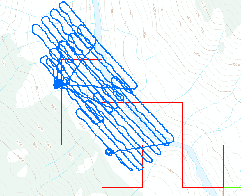
This weekend we completed an aerial mapping mission on a gold claim in BC. Our drone was able to complete four flights and took hundreds of photos. Through post processing we were able to produce a high resolution 3D model, digital terrain model (DEM) and a high resolution orthophoto mosaic.
3D Model Produced from Drone
The flights were all completed in one day. Two flights had to be cancelled. One due to excessive wind, the other due to a bald eagle chasing the drone. That is the first time I’ve seen a bird chase a drone, the eagle was closing in before I diverted the drone to come home. We were able to cover an area of 2.2 square kilometers with high resolution photography. Each flight covers about 250 acres just short of 1 square kilometer per flight.
UAV Flight Paths
The photo quality that was produced is outstanding. With this flight pattern a consistent photo resolution of 4.0 cm/pixel was obtained. To put that into prespective Google Earth’s highest resolution data is at 65cm/px and the best satellite data you can buy today is 30 cm/px. Photogrammetry techniques and software were used to produce the 3D model, point cloud and mosaic stitching. This software as improved substantially in the last couple years. You do need a lot of computer horsepower to run the calculations though.
Lets take a look at some of the photos. The two photos below are showing the ghost town that is located just North of the claim boundary. Some ground photos of the same spot can be seen in this post, Southern Cariboo Prospecting Trip
Here is an image of the same spot in Google Earth for comparison:
Google Earth Ghost Town
This set shows my SUV which was set up as a base station for the UAV operations. I had a special antenna mounted on the roof and a laptop with the UAV ground control software inside the SUV. You can clearly see the vehicle and I am standing just behind it.
Here’s a short video of me launching the drone. Its a pretty simple system, once all the pre-flight programming is complete you shake it three times and send it on its way.
Here is an overview of the 3D model that was produced. We essentially created a 3D environemnt similar to a video game that you can fly around in and check out terrain features. Its similar to google earth except much higher resolution. The second image is actually from within the 3D model, not a photograph.
3D Model of Claim AreaInside the 3D model
All the data that we produced with this drone is georeferenced. That means that each pixel has a real world coordinate and the model matches up with its real world position. Here’s a couple shots of the orthophoto and the DEM overlayed in ArcGIS.
You might be wondering why go through all this effort? Yeah drones are cool and all but what does this imagery offer to placer miners? The biggest thing we are looking for is ancient river channels or paleo-placer deposits. Using the high definition 3D imagery we can look for signs in the terrain where an ancient channel may have been. In addition to ancient channel mapping we can plan access for people and equipment, analyze land forms for placer potential and know where we can set up machines that need water.
In the future we plan to do some subsurface mapping with a ground penetrating radar system. This will parallel nicely with the UAV data to give us a clear map of the subsurface gravel layers.
These services are provided by West Coast Placer, if you are interested in drone imagery send us a note via the contact page.
Check out our Drone Services page for more details, Drone Services.
West Coast Placer is pleased to announce that we are now offering drone services. We recently acquired an aerial mapping UAV capable of collecting high resolution aerial imagery and topo maps.
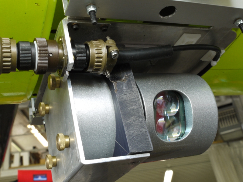
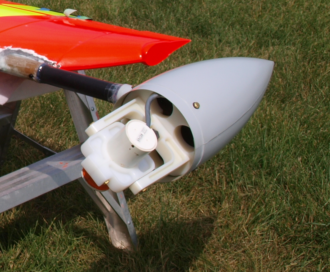
Our Drone
Our drone carries a high resolution camera and can cover several square kilometers in one flight. To do more flights we just have to land and change the batteries. The drone is fully autonomous and collects GPS data in sync with the photography. It is a great little package that can deliver amazing results.
Sample Imagery from Drone
We can deliver high resolution orthomosaics in deliverable formats such as GeoTIFF, JPEG, PNG or Google KMZ. Orthomosaics are a composite image of individual photos stitched together to create one large image. They also have coordinates tied to each pixel so that features in the image match up to their real world position. Our drone can produce deliverable 2D or 3D data up to 4cm/pixel. The best and most expensive satellite data that you can currently buy only reaches 15-30cm/px. Here is an image to show the comparison of our data vs Google Earth.
Through processing the flight data we can provide 3D imagery as well which can be used to create topographic data which can be delivered as a DEM, point cloud or other formats depending on the requirements of the job.
Sample Imagery from Drone
Our operator is experienced at operating and developing UAVs with many flight hours to under his belt. We meet all the requirements set out by Transport Canada. We are interested in flying for any needs that a client might have. Of course we have a special interest in placer operations. We are currently working on a technique to utilize the UAV to discover ancient river channels and other features of interest to placer miners.
Please contact us through the contact page for more information and to discuss your project.