
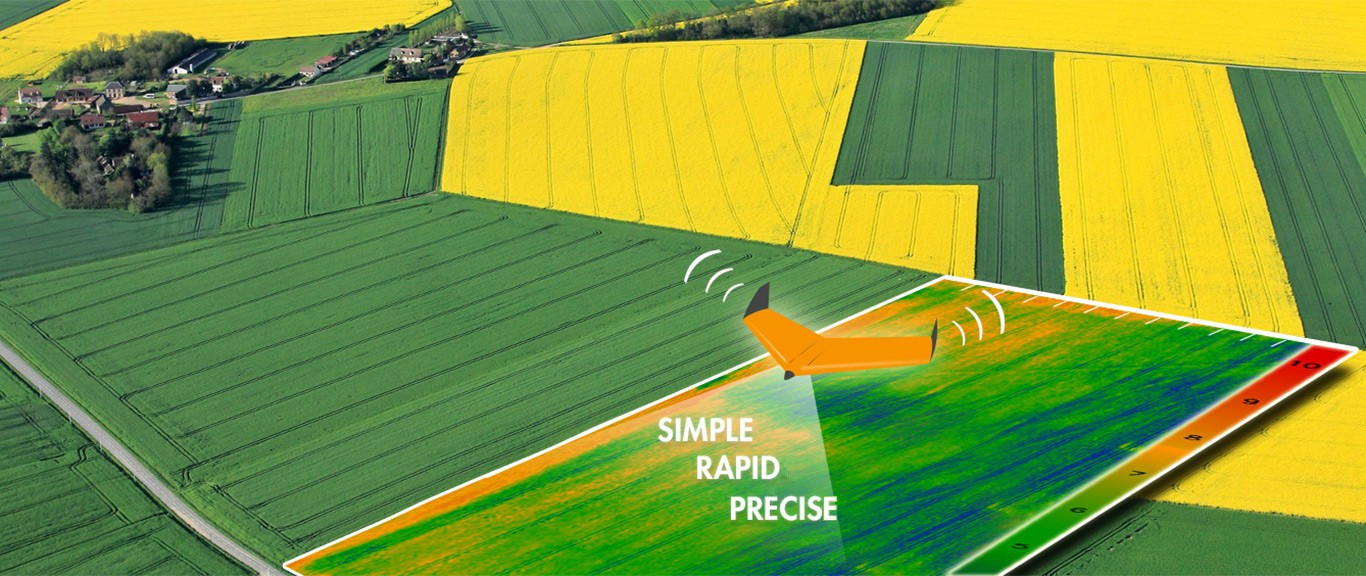
Drones give us a way to provide precise and rapid information on the condition of your crops. Our multispectral image sensor enables us to gain valuable information that will increase efficiency in your field. Our long range drone can cover over 600 acres in a single flight, that’s an entire section! From the ground you can only see a small percentage of a field, using drones we will scout 100% of your field.
We work all over Western Canada (BC, Alberta, Saskatchewan). Fully legal and we have liability insurance up to $1,000,000.
Our system brings high resolution aerial data to projects with small budgets.
Our drone data can be used directly to create a spraying prescription by utilizing specialized software. In addition to high resolution color aerial photos we can provide NDVI maps and topographical maps.
Our imagery can help farmers and agronomists in many ways:
- Determine level of Chlorophyll
- Plant health and stress level
- Optimal fertilizer use
- Nitrogen Management
- Identify insects and pest in crop
- Analyze plant disease
- Plant or weed identification
- Farm plan development
- Cultivation planning
- Harvest planning according to vigor

The topo maps that we produce will show you low lying areas in your field where water is likely to collect.
Your data will be available securely via the internet. You can use a tablet, computer or smartphone to see your field as you’ve never seen it before. Additionally we’ll provide printed maps and processed GIS data that you can use on you computer. We’ll help you to fully understand the data while on site.
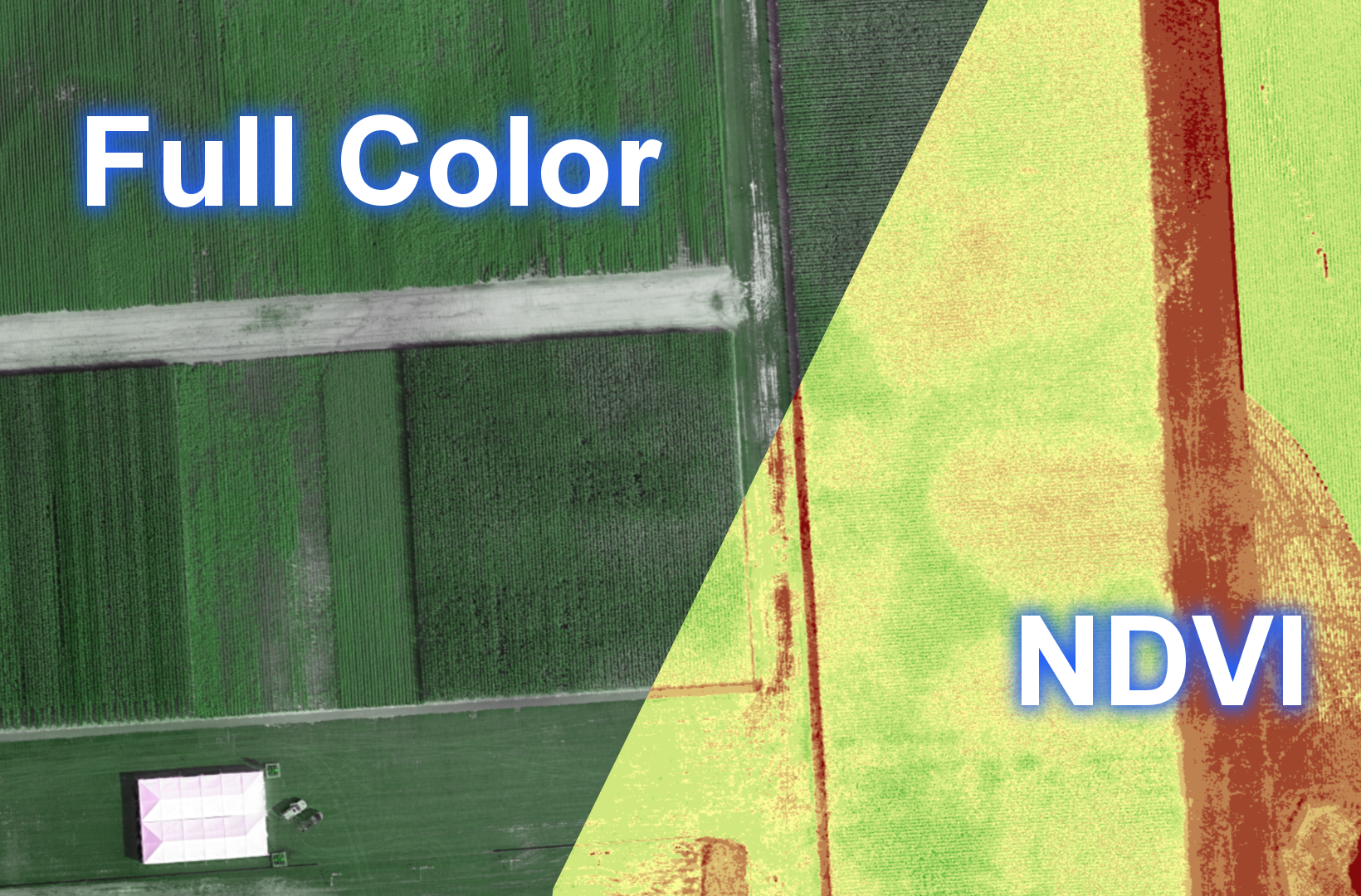
What’s an NDVI?
NDVI or normalized difference vegetation index, is the same technique that NASA uses to detect water on Mars. This is a form of remote sensing which produces a color coded map of relative crop health. Think of the map as a weather map but instead of temperature the colors represent crop vigor.
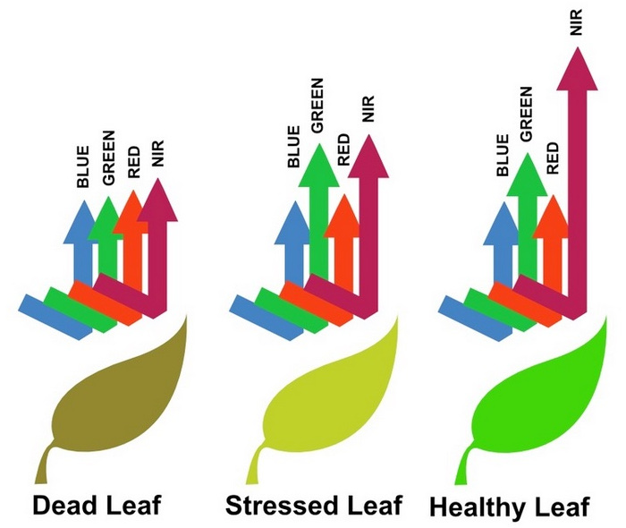
A normal, healthy, plant will absorb visible blue and red light and reflect green visible light, which is why they appear green to our eyes. In addition to green visible light, plants also reflect Near-Infrared (NIR) as this type of light isn’t actively used for the photosynthesis process. When a plant is weak or diseased, reflection of this NIR light is greatly decreased. Since red light is still being absorbed the same as a healthy plant, our specialized software calculates the difference in what is being reflected across a field of crops. Once calibrated and processed, it will become clear which plants are thriving and which are struggling.
Bottom line: NDVI = plant health.
Sample Data
These photos are all from the same flight over a farm. NDVI and DVI are maps of the crop health, the DEM is a digital elevation map (topo), and the color is a high resolution full color image. These maps are produced from hundreds of single photos taken with a multispectral sensor on the drone. After processing the images are stitched together and georeferenced.
Click for larger images.


High Resolution
Our full color photos and digital map products achieve a resolution of 4cm/px. By contrast Google Earth’s highest resolution data is at 65cm/px and the best satellite data you can buy today is 30 cm/px and is quite expensive. Check out the image below to see what how our resolution compares to Google.

This drone can cover approximately 650 Acres in one flight. We have multiple batteries and can currently do up to 5 flights per day. Flight planning will be completed prior to arriving at a site to ensure safety and compliance with Transport Canada regulations. We also hold a $1,000,000 liability insurance policy for all UAV operations. To discuss your project please send an email from the contact page.