Finding an ancient river channel is the holy grail of placer gold exploration. If you’re in a gold-bearing area, old river channels can hold the kind of unlocked treasures that dreams are made of. Prior to the gold rushes of the mid-1800s, you could have walked up to a virgin stream with untouched gold nuggets sitting in the bottom. That is an extremely rare discovery today. Ancient river channels are hard to find but that’s why many channels are still undisturbed waiting for a smart prospector to discover them.
There are undiscovered paleochannels hidden to the naked eye all over the goldfields of North America, and other gold placer districts all over the globe. Advances in technology have aided in the discovery of these ancient channels, some of the tried and true methods still hold true today. How can you find something that you can’t see? This article will explain what paleochannels are and how we find them.
Paleochannels have many names. Such as:
- Tertiary Channels
- Periglacier Channels
- Quaternary Channels
- Ancient Channels
- Paleo-gulches
- Ancestral Rivers
- Paleo-valleys
- Buried channels
- Stranded Channels
- Inverted Paleochannels
- Abandoned Channels
- Ancient Rivers of Gold
Some of those terms refer to specific ages or other characteristics of the channels but they all basically refer to the same thing, river beds that have run dry and have been buried by sediment. There are lots of reasons why a river might change its course but the end result is more or less the same.
The definition of a paleochannel is:
a remnant of an inactive river or stream channel that has been filled or buried by younger sediment
Paleochannels can form in many ways. Either slowly over time or abruptly from things like tectonic activity, glacial dams, mudslides, volcanic eruptions, or by human intervention.
When reading about ancient channels there are terms that often come up such as preglacial, periglacial, tertiary, quaternary, and many others. Those are just adding a time period to the formation of these channels, they’re really all the same thing. “Tertiary channels” are often written about in western North America, but that just means they are ancient channels that were formed during the tertiary period. The tertiary period ranged from the time of the extinction of the dinosaurs (the K-T extinction) about 66 million years ago to the beginning of the ice age period about 2.6 million years ago.
The quaternary period is more recent ranging from 2.6 million years ago to today and has experienced several periods of glaciation. The Pleistocene and Holocene are also part of the Quaternary Period.
Preglacial and Periglacial refer to the timing of a channel in relation to a glacial period. Approximately a dozen major glaciations have occurred over the past 1 million years, the largest of which peaked 650,000 years ago and lasted for 50,000 years. The most recent glaciation period, often known simply as the “Ice Age,” reached peak conditions some 18,000 years ago before giving way to the interglacial Holocene epoch 11,700 years ago.
People sometimes get hung up on some of the terminology but whether a channel formed in a specific time period doesn’t make a huge difference to a placer miner. To be honest, when it comes to placer exploration, every ancient channel in a gold-bearing area is worth exploring, regardless of the age. A channel that only formed 100 years ago has the same likelihood of containing placer gold as one that formed 3 million years ago during the tertiary period. What really matters is whether the creek that formed the channel carried gold or not.
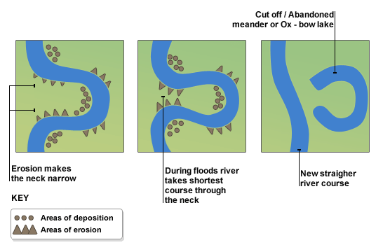
A familiar feature that resembles a paleochannel is an oxbow lake. These formations occur when a meander in a river gets cut off. You can observe oxbow lakes in many places, eventually, the lake will run dry and you’ll end up with a buried paleochannel. Oxbows can be gold-bearing even though they are not considered a “paleochannel”. Streams meander and change course frequently, in some places you can watch oxbows forming in near real-time.
Rivers and streams form all kinds of channels, for different reasons but they all have some things in common. A paleochannel is really the same thing as the rivers and streams that you see today, it was just rerouted and buried by sediment. When prospecting a paleochannel the same rules apply, the old river had inside bends, exposed bedrock, boulders, etc.
The character of a Paleochannel
There are several characteristics that make up a paleochannel. They can tell you a lot about its setting and the depositional environment, which in turn can give you a good idea if placer gold will be present or not.
Those characteristics are width, sinuosity, thalweg, slope, and age.
Channel width is an important metric for characterizing streamflow and depositional environment. The width is measured perpendicular to the centerline from bank to bank. The width can tell you a lot about a channel, especially when combined with other factors.
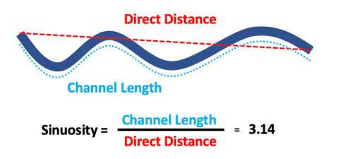
Sinuosity is the measure of how much a channel meanders. The sinuosity is measured by dividing the channel length by the straight line distance down the valley axis. You can infer the slope, transport capacity, and other factors from the sinuosity alone. More sinuous channels, those that meander a lot, occur on gentle slopes, the straighter the channel, the steeper the slope.
Thalweg is a funny word that comes from German meaning “valley way”. Don’t ask me why we use a German word but we do. The thalweg is simply the deepest part of the channel which is colloquially referred to as the “gutter”.
The slope, along with the width and sinuosity is used to calculate the ability of a channel to transport sediment. The slope is the average angle of the valley in which a stream lies. From a placer standpoint, we know that if our sluice box is too steep the gold won’t catch in the matting, if it’s too shallow the sediment won’t clear. A creek is no different.
The famous California goldfield geologist, Waldemar Lindgren studied channel slopes in relation to placer deposits in BC, California, and the Yukon in 1933. Lindgren determined that the optimal slope for placer formation is a 30-foot drop to the mile or 6 meters per kilometer which calculates out to a ratio of 0.06 or 0.34°. The Klondike’s Bonanza Creek averages 50 feet to the mile (0.01). Dominion Creek, in the Klondike, averages .02; there are slope breaks to 0.01 and that is where most of the gold was trapped. Almost all placer-bearing channels in BC range from a slope of 0.02 to 0.10.
Types of Paleochannels
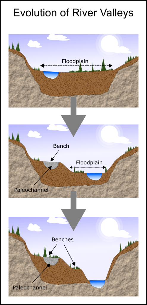
Bench Channels occur on high benches or terraces above a current river. The flat benches represent the ancient valley floor. As river valley systems evolve the river cuts deeper and deeper into the bedrock leaving old channels high and dry. If you retrace the history the old river would have sat at a higher elevation than it does today.
Bench channels typically have a single channel and aren’t braided. The slope, sinuosity, and width tend to be similar to the current stream. These paleochannels typically run parallel to the existing steam but not always.
High benches can be observed in many river systems in western North America and many rich paleochannels have been discovered and mined within them.
Buried Paleochannels within modern valleys can be adjacent to or underneath an existing alluvial stream within the same valley. The extent of these channels is difficult to determine due to the complexity of their setting. These channels can be very deep and sometimes buried under several different glacial or fluvial events. The sinuosity, width, slope and direction often mirrors that of the existing stream but not always.
These channels are difficult to mine due to the continual flow of water from the existing stream. A bedrock drain or lots of pumping is often required.
A great example of this type of paleochannel is the Wingdam Mine on Lightning Creek in the Cariboo. Omineca Mining and Metals has found a unique solution to mining their deposit, check out the video below.
Paleogulches are another type of ancient channel. They are gulches that dried up and were buried by sediment. Paleogulches have steep sides and a relatively steep gradient. They have low sinuosity and a relatively straight path. The channel often runs on or near bedrock due to the steep slope of the thalweg and high flow rate.
Gold in these deposits is usually coarse and hasn’t traveled far from the source. Paleogulch placers, like other buried-channel deposits, are typically covered by thick deposits of till, glaciofluvial deposits, and glaciolacustrine sediments.
Paleotrunk-valleys are similar to the paleogulches above. They are trunk valleys that were abandoned and filled with sediment. These deposits are often hundreds of meters wide and quite deep. Paleotrunk-valleys typically no longer have a stream running in them and tend to be totally filled with sediment leaving little to no surface expression.
The Bullion hydraulic mine near Likely, BC is an example of this type of paleochannel. The Bullion Pit produced over 120,000 ounces of gold over the lifespan of the mine. The famous Mary Creek deposit is another example of this type.
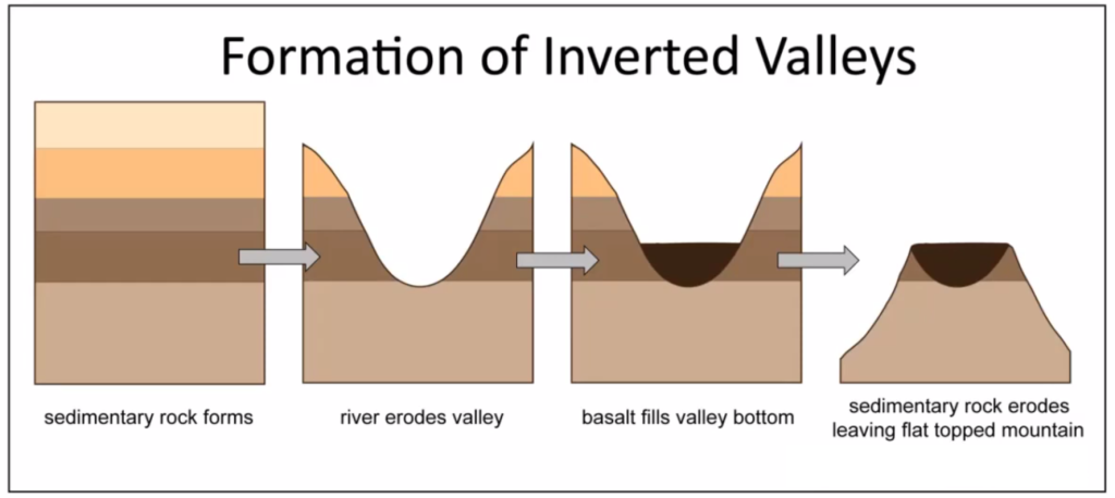
Inverted Paleochannels form in a totally different way. They sit high above the surroundings but not on a bench, and not in an existing valley, at least not usually. This type of paleochannel forms when a river valley is filled with lava from a volcanic eruption. The resulting lava cools into basalt and forms a protective cap that is much stronger than the surrounding rock. The result is that over time the surrounding rock is eroded but the basalt is much more resistant and protects the sedimentary rock below it, leaving a high ridge where the river used to be.
Inverted channels are more common in the southwestern United States in places like Utah, Idaho, and eastern Washington. I’m not aware of any gold deposits from inverted channels but it is possible.
An important note about paleochannels: not every channel contains gold. There are paleochannels all over the earth, only ones in gold-bearing areas are significant for gold prospecting. After all, the ancient channel won’t contain gold unless the creek that created it carried gold in its sediment load.
Most parts of North America have been exposed to glaciation at some time or another. The more northern parts have seen extreme transformations of the landscape due to glaciers scouring the surface of the earth. This makes finding ancient channels a lot harder.
It’s rare to find an entire river system entombed in sediment in BC, for example. What you usually find are fragments of ancient rivers. Some can be only a few hundred meters long while others can stretch for 10s of kilometers. There are often pieces missing due to glacial or other types of erosion.
The job of the prospector when exploring an ancient channel isn’t too different from a crime scene investigator on CSI. You’re dealing with fragments of channels and what you want to do is add up the clues to reconstruct the crime scene. Modern prospectors use a variety of tools to put those clues together.
How to find a paleochannel
Now we know the types of channels and a little bit about them. How do we find a paleochannel that we can mine?
One of the tell-tale signs of a paleochannel is finding compacted river gravels in an exposed bank. If you’re in the right place and you’re lucky enough to come across river gravels in an exposed bank you could have discovered an ancient channel. Old river beds have certain characteristics that differ from other materials that you’d often see in an exposed bank.
An old river bed will have the following features:
- Rounded river rocks
- Densely packed
- Sorted by size
River beds look different than glacial till, for example. Till will generally have different sized rocks randomly jumbled together, not sorted. Till can have rounded rocks but they are usually accompanied by angular rock of different sizes. A river bed should have bigger rocks at the bottom and finer, rounded gravels on top. River beds are packed together similar to the way that a brick wall is put together, everything fits together tightly with sand and gravel filling in the gaps. It’s not always totally obvious but if you see these signs it’s worth exploring further.
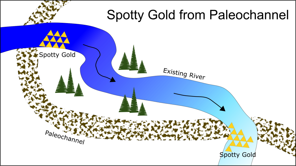
Spotty pay is another potential sign of a paleochannel. If there are sections of a creek that pay well and contain really good gold while other sections are barren that can be due to a rich paleochannel. Sometimes rivers don’t carry any gold of their own but redeposit gold from an ancient channel. It’s also possible that gold is washing down from a hardrock deposit, either way it can pay off big time to investigate spotty pay areas. The same is true when there are several creeks close together and they only have placer gold in a certain region on each creek. If the hot spots on several creeks line up there is probably a reason and it could be that the creeks all cut through a hidden paleochannel.
The old-time miners often discovered ancient channels by digging shafts by hand. Many channels have been discovered in this way. It’s not very effective by today’s standards but some people still use this technique. The presence of compacted river gravels underneath layers of sediment are a good sign that a paleochannel is present.
The old-timers would often dig numerous shafts looking for a channel and would dig a horizontal shaft known as a drift once a channel is located. That involves a lot of backbreaking physical work with a low chance of success but during the 1800s and early 1900s, there weren’t as many options available as there are today.
Here’s a great 5-minute YouTube video that describes what compacted river gravels look like, as well as some of the geology at play:
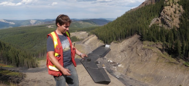
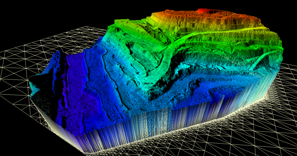
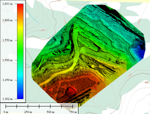
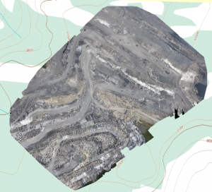
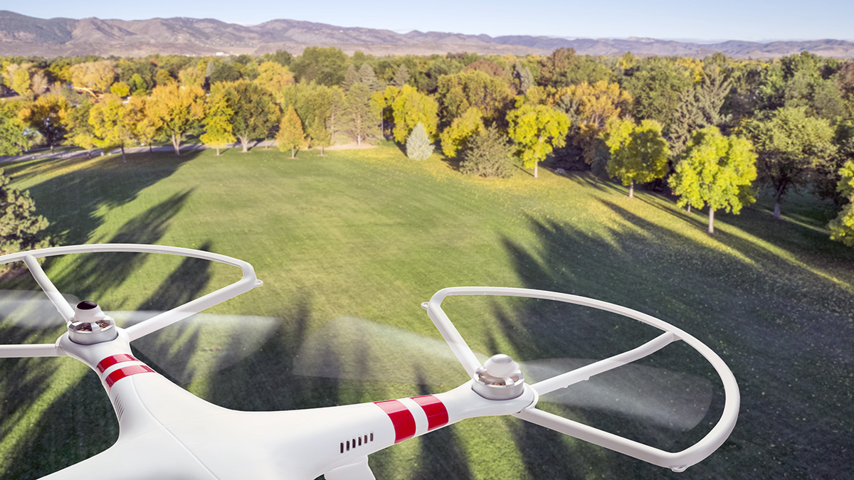
The modern prospector can benefit from advances in technology, especially computer mapping and GIS. Modern mapping tools such as Google Terrain maps can help to find the habitat where paleochannels are likely to be present. LiDAR and drone-based high-resolution terrain mapping can give highly detailed terrain maps which aid in locating favorable conditions for paleochannel exploration.
For example, river benches as described above can often be seen on topo maps. It’s unlikely to see a channel outright since they rarely have a clear surface expression, if at all, but you can narrow down the search area by looking at terrain that is favorable for channels to occur.
Once the search area has been narrowed down to a specific area more advanced techniques can be used to map the exact location and depth of a paleochannel.
There are several geophysical techniques that can map underground structures without having to excavate down to the channel level. Geophysics uses a variety of techniques to map the subsurface of the earth. Some work better than others for mapping paleochannels.
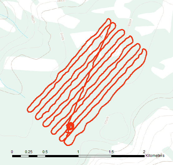
Magnetometer surveys have been used on many occasions to attempt to map ancient channels. A magnetometer is an instrument that measures changes in earth’s magnetic field. They are commonly used in hard rock exploration due to their rapid speed and relatively low cost. Magnetic survey results are usually presented in a map that looks like a thermal image except that instead of temperature you’re looking at variation in the magnetic field, measured in nano-tesla (nT). When exploring for a paleochannel the concept relies on trying to pick up the magnetic signature of concentrations of black sand. The survey usually involves recording measurements along lines perpendicular to the channel and looking in the processed data for anomalous magnetic highs where black sand concentrations are present.
Magnetic surveys have been used a lot in the past but have a very low success rate for mapping paleochannels. This is largely due to false positives from surrounding rock and weak concentrations of mineral sands. I haven’t seen any of these surveys that have actually been successful in locating a paleochannel on their own.
Ground penetrating radar (GPR) is another popular technique. GPR uses a system with two components, a radar source and a receiver. The GPR source emits radio energy of a specific frequency and the receiver records reflections of subsurface rock and soil layers. The survey is laid out in a similar way, with lines perpendicular to the channel.
GPR has also been used in many exploration programs with limited success. Some channels have been discovered in this way but GPR has a few drawbacks. The signal is attenuated by groundwater, clay layers, and permafrost. Under perfect conditions, GPR can map a channel but the data is often ambiguous and of poor quality.
Electromagnetic techniques such as resistivity have a much higher success rate but they have similar issues to GPR when it comes to groundwater. Geoelectrical resistivity tomography (GRT) surveys have a much higher success rate than GPR or magnetometer surveys. The way they image the channels is a bit vague but many channels have been found with this technique. GRT has a few drawbacks as well, conductive bedrock, groundwater, and other factors can lead to unpredictable results.
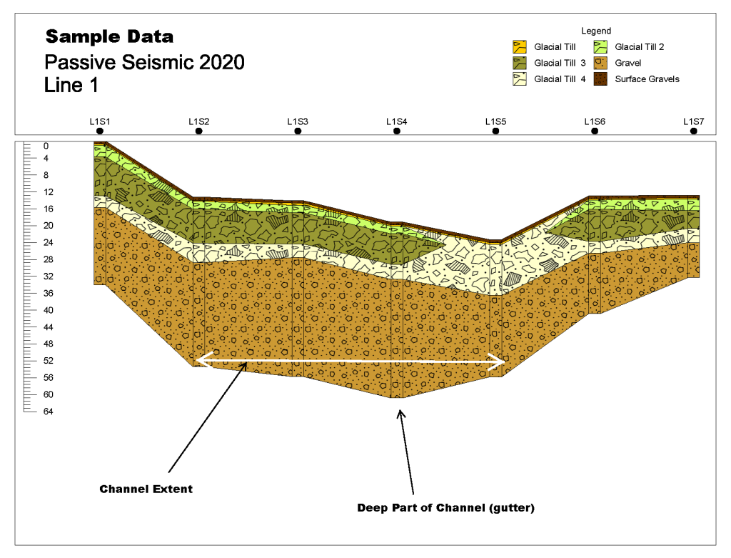
Seismic surveys have the highest success rate for mapping paleochannels. Seismic works in a similar way to GPR but instead of radio waves it uses vibrational energy. There are two types of seismic used today. Refraction and passive seismic. Refraction surveys have been around for a long time and have been used to find many paleochannels with a very high rate of success. A refraction survey uses an energy source such as dynamite or a specialized shotgun to introduce energy into the ground. An array of sensors called geophones are laid out in a survey line to record the reflected waves that bounce back off the subsurface layers. The timing and velocity of seismic returns give information about the density of layers and their depth from the surface.
Seismic energy passes through groundwater, clay, permafrost with ease and if done correctly will accurately map the subsurface layers. The drawback to refraction seismic is the cost. It takes an experienced crew and expensive equipment to perform this survey correctly.
Passive seismic surveys are a new technique that has only started to be used in the last decade. The passive technique does not require an energy source and can be done with a much smaller crew at a fraction of the cost. Passive seismic is the new kid on the block but it has proven to be very effective at mapping hidden paleochannels. Passive surveys also remove the need to cut lines which lowers costs even more. More info on this technique here, bedrock mapping.
Once a channel is identified and the location is known, further testing is required. The above techniques are able to show the location, shape and character of a paleochannel but won’t give you any information about the gold content. For that you need to take actual samples.
Depending on the depth of the channel there are several options. If it’s shallow enough you can test with an excavator but that is rarely the most economical option. In most cases you need to drill.
There are several drilling techniques used in placer exploration and there are pros and cons to each.
Auger drills are popular among placer miners due to the relatively low cost and perceived sample size but they have serious drawbacks. Augers struggle with large rocks and boulders, and can’t usually penetrate bedrock. They also tend to ovalize the hole leading to sample contamination and material loss down the hole.
Sonic drills are the most effective option. A sonic drill uses a high frequency vibration to bore through soil and rock. These drills take undisturbed samples and can drill through gravel, boulders, and bedrock. You can’t beat the sample quality and efficiency of a sonic drill but the costs of this type of drilling can be quite high.
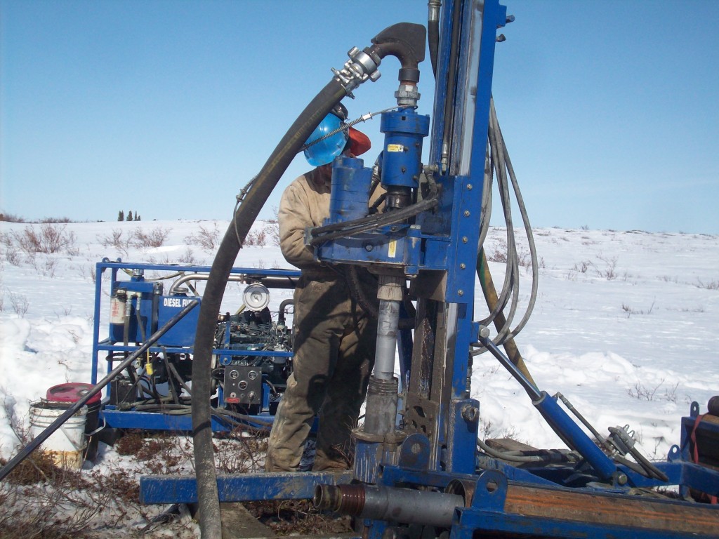
Reverse circulation (RC) drills also work really well. These drills use a downhole hammer that pulverizes the rock and gravel into chips which are pushed to a collection cyclone at the surface using pressurized air. RC drills also work really well for placer exploration. RC drilling has been used to successfully map many hidden paleochannels in BC and the Yukon.
Rotary diamond drills can also be used with specialized drill mud. These are less common than RC or sonic but have been successful in some situations.
Once you have identified the places where paleochannels are likely to occur from topographic maps, conducted geophysical surveys to map the channel and taken drill samples to confirm the channel depth and gold grades you’ll have the information necessary to develop a mining plan. If the gold grades are high enough to profitably mine then you’re ready to start production.
Many of the richest placer mines in the world exist on paleochannel deposits. They are notoriously difficult to locate and prospect but the results can be extraordinary. Advances in modern technology give today’s prospector an advantage that wasn’t available to miners in the past. There are hidden paleochannels in every mining district and even in places that have been mined for over a century. Discoveries are being made in places that nobody thought to look at in years past. Keep your eyes open for indications of an ancient river channel, there just might be a bonanza sitting right under your feet.

