How to Lose Your Shirt in Placer Mining

How to Lose Your Shirt in Placer Mining

What makes placer mining unique is that you have control over your own destiny. The barriers to entry are low and a small group of people can have the opportunity to develop a mine and produce gold on their own terms. You don’t need a corporation and millions of dollars to succeed in placer mining. That freedom is a double-edged sword though. The majority of placer miners bite off more than they can chew and fail miserably.

This article lists some sure-fire methods to lose your shirt in placer mining that apply to large-scale mines and small hand operations alike. By knowing the mistakes that others have made you can avoid making the same mistakes yourself.

Three Placer Wash Plants

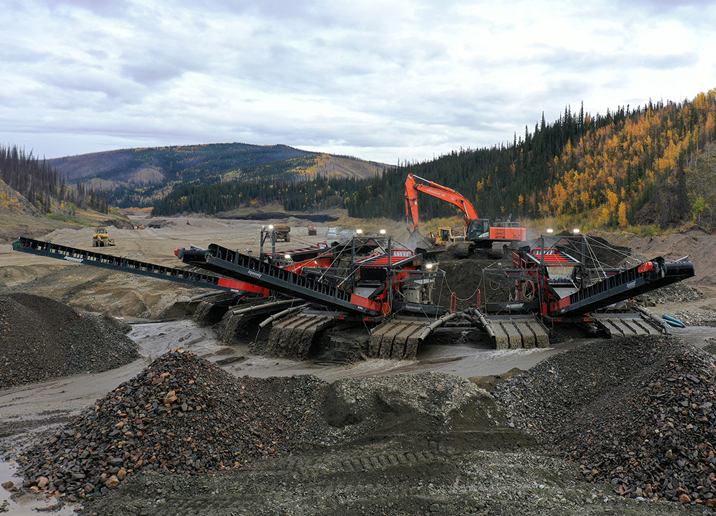
Too much equipment, Too soon

There is a lot of equipment available to placer miners these days. A lot of rookie miners will buy way too much equipment before they even get started. That’s a great way to blow your budget without even finding any gold.

The fitness industry relies on this same principle. It doesn’t take much effort to go out and buy a brand new stationary bike but just owning that machine isn’t going to give you abs of steel. Getting in shape takes hard work and dedication. Placer gold exploration works the same way. Some miners seem to think that buying a bigger wash plant, a bigger excavator, or even the latest and greatest highbanker will somehow make gold appear. It’s easy to buy equipment, finding gold is hard.

If you want to blow your whole mining venture in the first season then buy too big of equipment before you’ve even explored your claim. You’ll be part of the illustrious club of would-be miners who failed before they even got started.

We were contacted recently by a miner who wanted to hire West Coast Placer to do some bedrock mapping. The miner had recently purchased a $250,000 wash plant. We asked them where they were mining and they responded, “We’re hoping that you can help us figure that out.” They didn’t even have a claim yet. That is not a recipe for success.

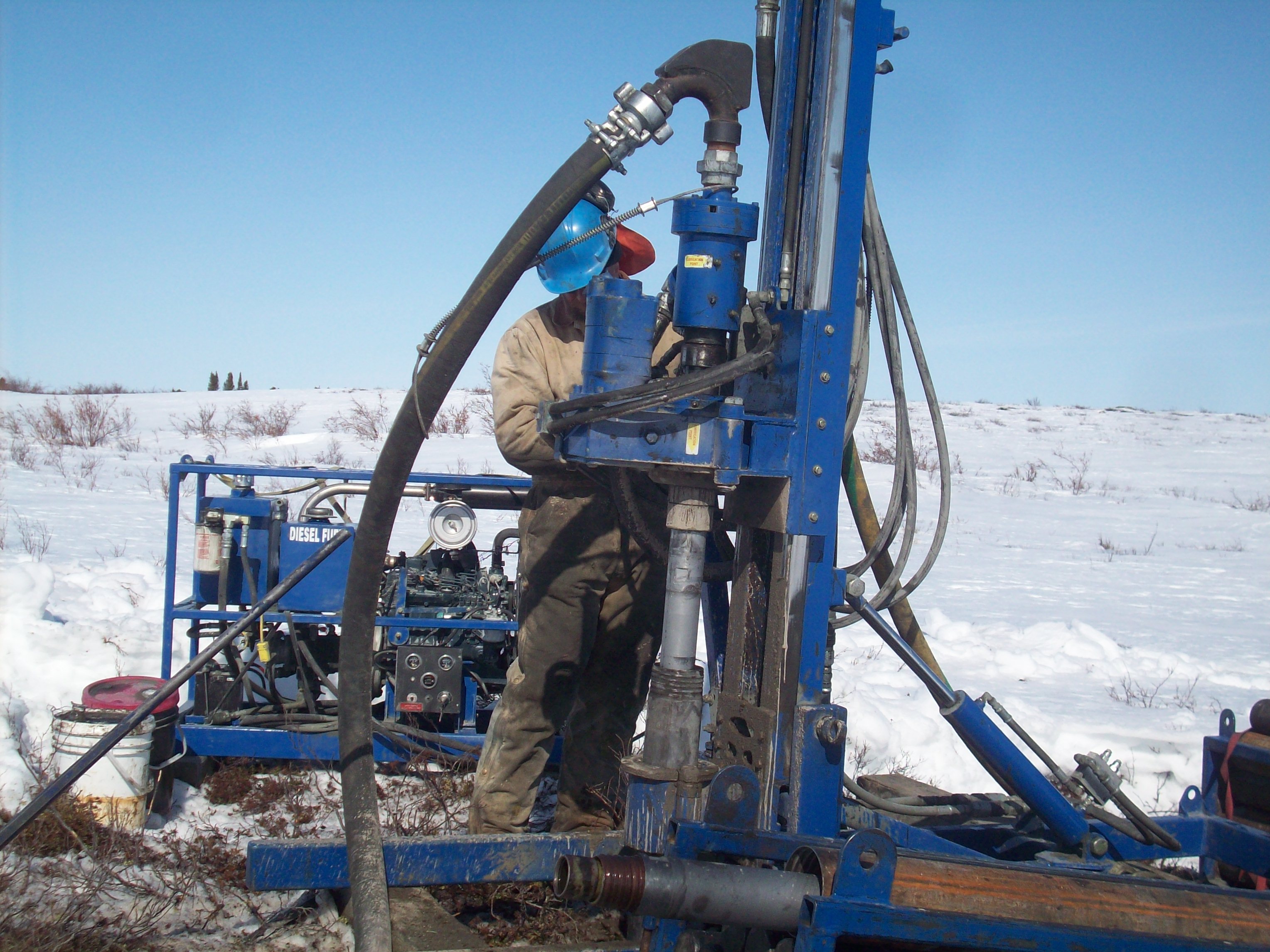
Other miners have spent their money on excavators, loaders, and high-end camp setups but then had nothing left to buy a drill. At different stages of placer exploration you’ll need different equipment. Having a solid plan will help you figure out what is required at each stage.

If you want to be successful explore the claim first and get the gear that you need to work in that specific situation. You don’t need a washplant until you’ve actually mapped out a mineable gold deposit and have a mining plan figured out. Start out with basic tools and expand as needed. During exploration the trick is to gather as much information as possible while spending the least amount of money.

Get hooked on a glory hole

We can all look at other miners who spent three years digging in the same spot totally convinced that it’s going to make them rich. We shake our heads and think of how stupid they are. However, a lot of miners fall into this trap.

What is it about glory holes that suck in the imagination of placer miners? It’s sort of like gold fever. Miner’s get hooked on the belief that one specific spot holds all the gold and that if they can just dig it up they’ll be rich.

This sickness can affect rookies and even some experienced miners. Sometimes it’s driven by a story from the past, or a misinterpretation of a geological feature. Getting hooked on a glory hole is similar to being in a romantic relationship that is totally toxic. All your friends know but you don’t realize it yourself until after the breakup.

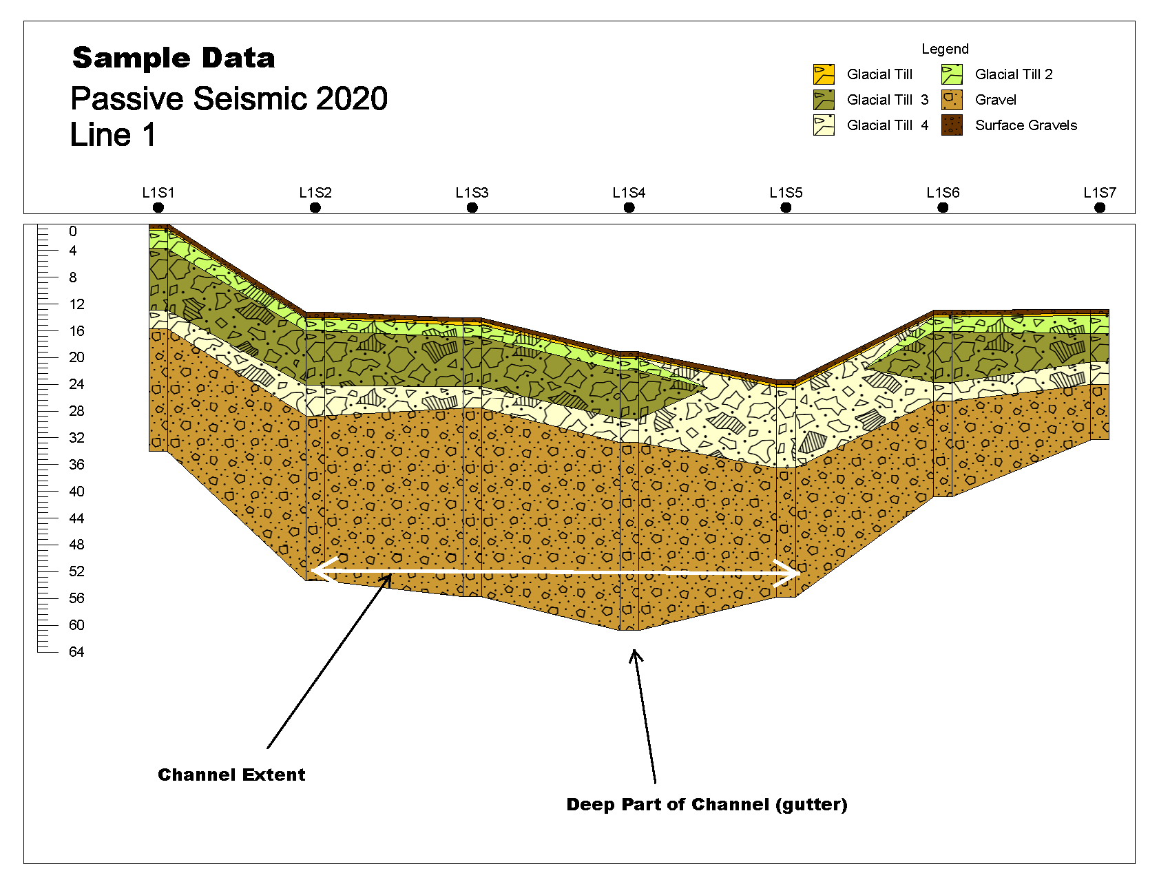
This situation can be easily avoided by proper sampling and testing. A whole season’s worth of excavating in the wrong spot ( or multiple seasons for some people) can be avoided with one drill hole. If you are convinced that there is a whole bunch of gold in one spot, and you haven’t tested to confirm, then you have fallen victim to the glory hole trap.

Drink your own Kool-aid

Every placer miner has their reasons for digging and exploring in the spots that they do. Sometimes that’s based on good test results but often it’s based on nothing more than imagination.

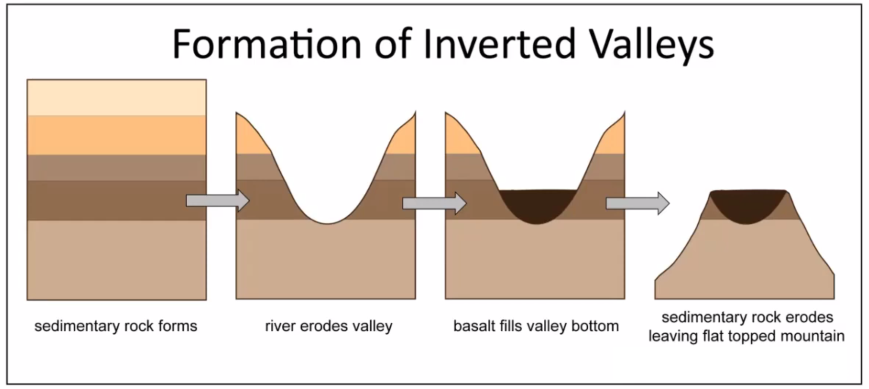
Many miners have developed a form of fairy tale in explaining the gold deposits on their claim. The geological, fluvial, and glacial environments that create placer pay streaks are extremely complex. There are entire fields of science that dedicate themselves to understanding these processes. Even an expert geomorphologist can’t walk up to a placer claim and tell you what material has been deposited over the last 4 glacial periods, where the ancient channels are located and what ancient streams used to flow over the mountain range. If you think you know those answers then you are heading down a dangerous path.

I’ve heard a lot of stories from placer miners who seem to know the exact play-by-play movements of glaciers during the last ice age and therefore know exactly where their gold has been accumulated. Obviously, they don’t have reliable knowledge of the geological history of their claim but they have convinced themselves that they do.

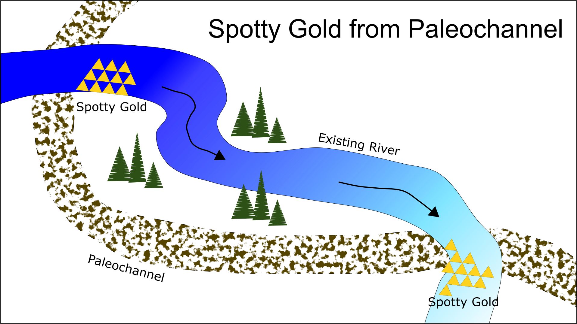
Others are convinced that there is a gold source up the mountain and it has puked out placer gold in a specific location that they’re about to mine. All without sampling and mapping out deposits.

It takes massive amounts of time and money to reliably recreate glacial movements. They are extremely complex and hard to trace. There are well-funded research projects that study these kinds of things with teams of experts and even they are not 100% certain.

If you think that you have those answers and haven’t hired expert geomorphologists, drilling companies, and performed large-scale studies to find out, then you’re just fooling yourself.

Truthfully in placer mining, you don’t need to know how the gold got there. All you have to do is test and sample the ground to find out where the gold is right now. Finding mineable placer deposits is hard and there are no shortcuts. There are techniques that work really well but believing in your own fairy tales isn’t going to make the gold appear. It’s much better to assume that you know nothing and explore in a systematic way.

Gold Legend Map BC

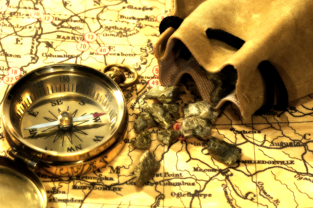
Put too much emphasis on stories from the past

Every creek has a success story from the past about an old-timer who pulled out some rich gold from an ambiguous location nearby. They usually go something like this:

“In the 1920’s Johnny Miner pulled out a 30-ounce nugget from somewhere up on that hill over there.”

Other stories involve drifts built by Chinese miners in the 1890s or a rich mine that was wiped out by a wildfire never to be found again. They have a lot in common with urban legends with the right mix of potential gain and just enough details to keep you interested.

There are lots of stories like this and a lot of them are true. Being a placer miner in the 21st century involves being a little bit of a historian as well as an explorer. After all, there are pretty much zero creeks in the world that haven’t had a pan dipped in them at least once before.

There are several issues with historical information that sometimes slip through our radar. We all know that clickbait stories on the internet are probably exaggerated to capture our attention. That phenomenon is not a new invention. Speculation and hype have always been part of mining. It was probably even worse during the gold rush periods of the late 1800s. Testing techniques are not standardized either. Even if a story is meant to be factual the miner might not have had a reliable technique to test his grades. You could fall victim to second-hand confirmation bias from 100 years ago and not even know it.

Whether these stories are true or not you still need to do your own testing. Reliable historical information can be an excellent starting point but it must be taken with a grain of salt. If you have truly uncovered some historical information that provides evidence for a forgotten placer deposit then start testing that area. Remain objective and if the test results don’t show what you’re expecting then move on.

Far too many miners have spent their time and budget blindly searching for a rich paystreak that was mentioned decades ago. I personally know miners who have spent hundreds of thousands of dollars searching based on three sentences of historical information.

Keep an open mind and let the evidence guide you. It’s important to know when enough is enough.

Insufficient sampling

We’ve all heard the old adage that in real estate that the three most important things are location, location, location. In the world of placer mining, the three most important words are sampling, sampling, sampling.

Our Auger Drill

This is the single most important aspect of placer mining and exploration. Miners of all sizes have lost money and often their entire budget due to poor sampling. There are lots of reasons why miners forgo proper sampling. It costs money, it takes time away from mining, maybe they don’t know how to sample properly in the first place.

Sampling will make or break your placer operation. It must be done over a broad area and in a way that won’t fool the person doing it. The quality of sampling is just as important as the quantity.

For example, it is critically important to measure the volume of each sample accurately otherwise the grade calculations will be totally wrong. Say you sampled half an excavator bucket and found 3 grams of gold. Is that 3 grams per yard? Or half of that? It makes a big difference. Let’s say you’re using 5-gallon pails. Were they all full when you ran the sample? Half-full? Three quarters? Your grade calculations will change dramatically based on the volume.

Bigger samples are always better but there is a trade-off between lots of small samples and only a handful of big ones. Each situation and budget will call for variations in the sampling plan. You want to have enough locations tested to be confident that you understand the size and distribution of your pay streak while getting reliable results in each sample.

It’s important to test areas outside of the location where you think the best gold is. That means testing every depth interval from surface to bedrock as well as testing ground whether you think it’s a location that you can mine or not. Many miners have missed out on unbelievable pay because they only tested areas that they thought were favorable for mining. Here’s a tip, every spot is favorable for mining if the gold grades are high enough.

Placer exploration is a little bit like the board game Battleship, where you have to shoot missiles on a blind grid to sink your opponent’s ships. You start out knowing nothing but over time you gain evidence of where things are located, in this case gold instead of toy battleships. The same systematic approach will lead you to win Battleship as it will to mine a profitable placer deposit.

If you think you’ve done enough sampling, you haven’t. If you start washing gravels before you have sampled a broad area with verifiable tests you are guaranteed to lose your shirt.

Before you start mining make sure that you know the depth, location, and the grades of your pay gravels. There are a lot of opinions on what the proper way to sample is. The important thing is to be thorough and be consistent.

Get a Partner

Many great placer mining operations have met their demise due to disagreements between partners. It always sounds like a good idea at the time but partnerships fail for a variety of reasons. Most often financial disagreements.

Howard from the great mining classic, The Treasure of the Sierra Madre said it best,

“Ah, as long as there’s no find, the noble brotherhood will last but when the piles of gold begin to grow… that’s when the trouble starts.”

Gold does funny things to some people. Even people that you wouldn’t expect. There’s something about the yellow metal that affects us deep inside. It’s not just the financial value either. Silver, copper, uranium, platinum, and numerous other metals are mined in similar ways but people don’t get as emotionally attached to any of those things. The only other mineral that affects people in a similar way is diamonds.

Gold fever has existed as long as people have been mining. The primary reason that the Spanish explorers stumbled upon North America was the search for gold. Christopher Columbus wasn’t looking for America, his sole purpose was to find Cipangu, the island of “endless gold.” The Spanish explorers famously ravished and betrayed civilizations in the Americas to steal their gold. The betrayal met its climax in 1532 when Francisco Pizarro famously betrayed the Inca ruler Atahualpa.

Partnerships fail for many reasons but greed is often the primary factor. Sometimes personal finances fall apart, a partner gets divorced, falls behind on truck payments, anything can happen. A lot of placer mines that have done everything right and developed great gold deposits have fallen apart due to disagreements between partners.

Gold mining partnerships always start out with the best intentions but humans are complex and things can change. If you’re considering a partnership make sure the person or people that you’re going to join forces with are going to stick it out for the long haul. Make sure you have a solid contract in place that has been verified by a lawyer or notary.

They say a business partnership is like a marriage. You want to be careful who you’re going to bed with.

Mining Partner BC Gold Placer

Set Unrealistic Deadlines

One thing that has ruined the dreams of many would be gold miners is rushing the exploration process. Exploration, planning and logistics take time. Everyone is eager to start mining but it takes preparation to get to that point. A lot of the points in this article are often the result of setting unrealitic deadlines.

A lot of miners start buying wash plants or heavy equipment before they are ready to use that equipment. As a result they get trigger happy and skip important steps in the exploration process. I know a miner who recently told me that they have to start mining next season no matter what. This person quit his job and has started to buy mining equipment. At the time that we were discussing this he had not found a viable gold deposit yet. If he followed through with that plan he’d have definitely lost his shirt.

A lot of miners raise money by having people invest in their operations and those investors inevitably want a quick return on their money. Many placer operations have failed due to pressure from investors to fast track the mining process. This is one reason why partners or investors can kill your placer operation. If everyone onboard has realistic expectations about the time frames required for exploration in advance the project has a lot higher chance of succeeding. It’s important to be honest about how much time it’s going to take to explore for and find a gold deposit.

At West Coast Placer we provide exploration services to placer miners of all sizes. We’ve seen a lot of successful operations and have helped miners develop their properties into profitable mines. We’ve also seen a lot of ventures fail miserably. There are some practices that are guaranteed to lead to failure and yet rookie and experienced miners alike make these mistakes over and over again. Hopefully these tips will help you stay successful in placer mining and keep you from losing your shirt.

Paleochannel Hunting Guide

Paleochannel Hunting Guide

Finding an ancient river channel is the holy grail of placer gold exploration. If you’re in a gold-bearing area, old river channels can hold the kind of unlocked treasures that dreams are made of. Prior to the gold rushes of the mid-1800s, you could have walked up to a virgin stream with untouched gold nuggets sitting in the bottom. That is an extremely rare discovery today. Ancient river channels are hard to find but that’s why many channels are still undisturbed waiting for a smart prospector to discover them.

Klondike Wash Plant

There are undiscovered paleochannels hidden to the naked eye all over the goldfields of North America, and other gold placer districts all over the globe. Advances in technology have aided in the discovery of these ancient channels, some of the tried and true methods still hold true today. How can you find something that you can’t see? This article will explain what paleochannels are and how we find them.

Paleochannels have many names. Such as:

  • Tertiary Channels
  • Periglacier Channels
  • Quaternary Channels
  • Ancient Channels
  • Paleo-gulches
  • Ancestral Rivers
  • Paleo-valleys
  • Buried channels
  • Stranded Channels
  • Inverted Paleochannels
  • Abandoned Channels
  • Ancient Rivers of Gold

Some of those terms refer to specific ages or other characteristics of the channels but they all basically refer to the same thing, river beds that have run dry and have been buried by sediment. There are lots of reasons why a river might change its course but the end result is more or less the same.

The definition of a paleochannel is:

a remnant of an inactive river or stream channel that has been filled or buried by younger sediment

Paleochannels can form in many ways. Either slowly over time or abruptly from things like tectonic activity, glacial dams, mudslides, volcanic eruptions, or by human intervention.

When reading about ancient channels there are terms that often come up such as preglacial, periglacial, tertiary, quaternary, and many others. Those are just adding a time period to the formation of these channels, they’re really all the same thing. “Tertiary channels” are often written about in western North America, but that just means they are ancient channels that were formed during the tertiary period. The tertiary period ranged from the time of the extinction of the dinosaurs (the K-T extinction) about 66 million years ago to the beginning of the ice age period about 2.6 million years ago.

The quaternary period is more recent ranging from 2.6 million years ago to today and has experienced several periods of glaciation. The Pleistocene and Holocene are also part of the Quaternary Period.

Preglacial and Periglacial refer to the timing of a channel in relation to a glacial period. Approximately a dozen major glaciations have occurred over the past 1 million years, the largest of which peaked 650,000 years ago and lasted for 50,000 years. The most recent glaciation period, often known simply as the “Ice Age,” reached peak conditions some 18,000 years ago before giving way to the interglacial Holocene epoch 11,700 years ago.

People sometimes get hung up on some of the terminology but whether a channel formed in a specific time period doesn’t make a huge difference to a placer miner. To be honest, when it comes to placer exploration, every ancient channel in a gold-bearing area is worth exploring, regardless of the age. A channel that only formed 100 years ago has the same likelihood of containing placer gold as one that formed 3 million years ago during the tertiary period. What really matters is whether the creek that formed the channel carried gold or not.

Oxbow Lake

A familiar feature that resembles a paleochannel is an oxbow lake. These formations occur when a meander in a river gets cut off. You can observe oxbow lakes in many places, eventually, the lake will run dry and you’ll end up with a buried paleochannel. Oxbows can be gold-bearing even though they are not considered a “paleochannel”. Streams meander and change course frequently, in some places you can watch oxbows forming in near real-time.

Rivers and streams form all kinds of channels, for different reasons but they all have some things in common. A paleochannel is really the same thing as the rivers and streams that you see today, it was just rerouted and buried by sediment. When prospecting a paleochannel the same rules apply, the old river had inside bends, exposed bedrock, boulders, etc.

The character of a Paleochannel

There are several characteristics that make up a paleochannel. They can tell you a lot about its setting and the depositional environment, which in turn can give you a good idea if placer gold will be present or not.

Those characteristics are width, sinuosity, thalweg, slope, and age.

paleochannel thalweg

Channel width is an important metric for characterizing streamflow and depositional environment. The width is measured perpendicular to the centerline from bank to bank. The width can tell you a lot about a channel, especially when combined with other factors.

Sinuosity is the measure of how much a channel meanders. The sinuosity is measured by dividing the channel length by the straight line distance down the valley axis. You can infer the slope, transport capacity, and other factors from the sinuosity alone. More sinuous channels, those that meander a lot, occur on gentle slopes, the straighter the channel, the steeper the slope.

channel sinuosity

Thalweg is a funny word that comes from German meaning “valley way”. Don’t ask me why we use a German word but we do. The thalweg is simply the deepest part of the channel which is colloquially referred to as the “gutter”.

The slope, along with the width and sinuosity is used to calculate the ability of a channel to transport sediment. The slope is the average angle of the valley in which a stream lies. From a placer standpoint, we know that if our sluice box is too steep the gold won’t catch in the matting, if it’s too shallow the sediment won’t clear. A creek is no different.

The famous California goldfield geologist, Waldemar Lindgren studied channel slopes in relation to placer deposits in BC, California, and the Yukon in 1933. Lindgren determined that the optimal slope for placer formation is a 30-foot drop to the mile or 6 meters per kilometer which calculates out to a ratio of 0.06 or 0.34°. The Klondike’s Bonanza Creek averages 50 feet to the mile (0.01). Dominion Creek, in the Klondike, averages .02; there are slope breaks to 0.01 and that is where most of the gold was trapped. Almost all placer-bearing channels in BC range from a slope of 0.02 to 0.10.

Types of Paleochannels

Bench Channels occur on high benches or terraces above a current river. The flat benches represent the ancient valley floor. As river valley systems evolve the river cuts deeper and deeper into the bedrock leaving old channels high and dry. If you retrace the history the old river would have sat at a higher elevation than it does today.

Bench channels typically have a single channel and aren’t braided. The slope, sinuosity, and width tend to be similar to the current stream. These paleochannels typically run parallel to the existing steam but not always.

High benches can be observed in many river systems in western North America and many rich paleochannels have been discovered and mined within them.

Evolution river valley paleochannel

Buried Paleochannels within modern valleys can be adjacent to or underneath an existing alluvial stream within the same valley. The extent of these channels is difficult to determine due to the complexity of their setting. These channels can be very deep and sometimes buried under several different glacial or fluvial events. The sinuosity, width, slope and direction often mirrors that of the existing stream but not always.

These channels are difficult to mine due to the continual flow of water from the existing stream. A bedrock drain or lots of pumping is often required.

A great example of this type of paleochannel is the Wingdam Mine on Lightning Creek in the Cariboo. Omineca Mining and Metals has found a unique solution to mining their deposit, check out the video below.

Paleogulches are another type of ancient channel. They are gulches that dried up and were buried by sediment. Paleogulches have steep sides and a relatively steep gradient. They have low sinuosity and a relatively straight path. The channel often runs on or near bedrock due to the steep slope of the thalweg and high flow rate.

Gold in these deposits is usually coarse and hasn’t traveled far from the source. Paleogulch placers, like other buried-channel deposits, are typically covered by thick deposits of till, glaciofluvial deposits, and glaciolacustrine sediments.

Paleotrunk-valleys are similar to the paleogulches above. They are trunk valleys that were abandoned and filled with sediment. These deposits are often hundreds of meters wide and quite deep. Paleotrunk-valleys typically no longer have a stream running in them and tend to be totally filled with sediment leaving little to no surface expression.

The Bullion hydraulic mine near Likely, BC is an example of this type of paleochannel. The Bullion Pit produced over 120,000 ounces of gold over the lifespan of the mine. The famous Mary Creek deposit is another example of this type.

inverted paleovalley

Inverted Paleochannels form in a totally different way. They sit high above the surroundings but not on a bench, and not in an existing valley, at least not usually. This type of paleochannel forms when a river valley is filled with lava from a volcanic eruption. The resulting lava cools into basalt and forms a protective cap that is much stronger than the surrounding rock. The result is that over time the surrounding rock is eroded but the basalt is much more resistant and protects the sedimentary rock below it, leaving a high ridge where the river used to be.

Inverted channels are more common in the southwestern United States in places like Utah, Idaho, and eastern Washington. I’m not aware of any gold deposits from inverted channels but it is possible.

An important note about paleochannels: not every channel contains gold. There are paleochannels all over the earth, only ones in gold-bearing areas are significant for gold prospecting. After all, the ancient channel won’t contain gold unless the creek that created it carried gold in its sediment load.

Most parts of North America have been exposed to glaciation at some time or another. The more northern parts have seen extreme transformations of the landscape due to glaciers scouring the surface of the earth. This makes finding ancient channels a lot harder.

It’s rare to find an entire river system entombed in sediment in BC, for example. What you usually find are fragments of ancient rivers. Some can be only a few hundred meters long while others can stretch for 10s of kilometers. There are often pieces missing due to glacial or other types of erosion.

binary comment

The job of the prospector when exploring an ancient channel isn’t too different from a crime scene investigator on CSI. You’re dealing with fragments of channels and what you want to do is add up the clues to reconstruct the crime scene. Modern prospectors use a variety of tools to put those clues together.

How to find a paleochannel

Now we know the types of channels and a little bit about them. How do we find a paleochannel that we can mine?

One of the tell-tale signs of a paleochannel is finding compacted river gravels in an exposed bank. If you’re in the right place and you’re lucky enough to come across river gravels in an exposed bank you could have discovered an ancient channel. Old river beds have certain characteristics that differ from other materials that you’d often see in an exposed bank.

An old river bed will have the following features:

  • Rounded river rocks
  • Densely packed
  • Sorted by size

River beds look different than glacial till, for example. Till will generally have different sized rocks randomly jumbled together, not sorted. Till can have rounded rocks but they are usually accompanied by angular rock of different sizes. A river bed should have bigger rocks at the bottom and finer, rounded gravels on top. River beds are packed together similar to the way that a brick wall is put together, everything fits together tightly with sand and gravel filling in the gaps. It’s not always totally obvious but if you see these signs it’s worth exploring further.

Spotty pay is another potential sign of a paleochannel. If there are sections of a creek that pay well and contain really good gold while other sections are barren that can be due to a rich paleochannel. Sometimes rivers don’t carry any gold of their own but redeposit gold from an ancient channel. It’s also possible that gold is washing down from a hardrock deposit, either way it can pay off big time to investigate spotty pay areas. The same is true when there are several creeks close together and they only have placer gold in a certain region on each creek. If the hot spots on several creeks line up there is probably a reason and it could be that the creeks all cut through a hidden paleochannel.

Spotty Gold Paleochannel
The old-time miners often discovered ancient channels by digging shafts by hand. Many channels have been discovered in this way. It’s not very effective by today’s standards but some people still use this technique. The presence of compacted river gravels underneath layers of sediment are a good sign that a paleochannel is present.

The old-timers would often dig numerous shafts looking for a channel and would dig a horizontal shaft known as a drift once a channel is located. That involves a lot of backbreaking physical work with a low chance of success but during the 1800s and early 1900s, there weren’t as many options available as there are today.

Here’s a great 5-minute YouTube video that describes what compacted river gravels look like, as well as some of the geology at play:

The modern prospector can benefit from advances in technology, especially computer mapping and GIS. Modern mapping tools such as Google Terrain maps can help to find the habitat where paleochannels are likely to be present. LiDAR and drone-based high-resolution terrain mapping can give highly detailed terrain maps which aid in locating favorable conditions for paleochannel exploration.

For example, river benches as described above can often be seen on topo maps. It’s unlikely to see a channel outright since they rarely have a clear surface expression, if at all, but you can narrow down the search area by looking at terrain that is favorable for channels to occur.

Once the search area has been narrowed down to a specific area more advanced techniques can be used to map the exact location and depth of a paleochannel.

There are several geophysical techniques that can map underground structures without having to excavate down to the channel level. Geophysics uses a variety of techniques to map the subsurface of the earth. Some work better than others for mapping paleochannels.

Magnetometer surveys have been used on many occasions to attempt to map ancient channels. A magnetometer is an instrument that measures changes in earth’s magnetic field. They are commonly used in hard rock exploration due to their rapid speed and relatively low cost. Magnetic survey results are usually presented in a map that looks like a thermal image except that instead of temperature you’re looking at variation in the magnetic field, measured in nano-tesla (nT). When exploring for a paleochannel the concept relies on trying to pick up the magnetic signature of concentrations of black sand. The survey usually involves recording measurements along lines perpendicular to the channel and looking in the processed data for anomalous magnetic highs where black sand concentrations are present.

Magnetic surveys have been used a lot in the past but have a very low success rate for mapping paleochannels. This is largely due to false positives from surrounding rock and weak concentrations of mineral sands. I haven’t seen any of these surveys that have actually been successful in locating a paleochannel on their own.

Ground penetrating radar (GPR) is another popular technique. GPR uses a system with two components, a radar source and a receiver. The GPR source emits radio energy of a specific frequency and the receiver records reflections of subsurface rock and soil layers. The survey is laid out in a similar way, with lines perpendicular to the channel.

GPR has also been used in many exploration programs with limited success. Some channels have been discovered in this way but GPR has a few drawbacks. The signal is attenuated by groundwater, clay layers, and permafrost. Under perfect conditions, GPR can map a channel but the data is often ambiguous and of poor quality.

Electromagnetic techniques such as resistivity have a much higher success rate but they have similar issues to GPR when it comes to groundwater. Geoelectrical resistivity tomography (GRT) surveys have a much higher success rate than GPR or magnetometer surveys. The way they image the channels is a bit vague but many channels have been found with this technique. GRT has a few drawbacks as well, conductive bedrock, groundwater, and other factors can lead to unpredictable results.

Sample Cross Section

Seismic surveys have the highest success rate for mapping paleochannels. Seismic works in a similar way to GPR but instead of radio waves it uses vibrational energy. There are two types of seismic used today. Refraction and passive seismic. Refraction surveys have been around for a long time and have been used to find many paleochannels with a very high rate of success. A refraction survey uses an energy source such as dynamite or a specialized shotgun to introduce energy into the ground. An array of sensors called geophones are laid out in a survey line to record the reflected waves that bounce back off the subsurface layers. The timing and velocity of seismic returns give information about the density of layers and their depth from the surface.

Seismic energy passes through groundwater, clay, permafrost with ease and if done correctly will accurately map the subsurface layers. The drawback to refraction seismic is the cost. It takes an experienced crew and expensive equipment to perform this survey correctly.

Passive seismic surveys are a new technique that has only started to be used in the last decade. The passive technique does not require an energy source and can be done with a much smaller crew at a fraction of the cost. Passive seismic is the new kid on the block but it has proven to be very effective at mapping hidden paleochannels. Passive surveys also remove the need to cut lines which lowers costs even more. More info on this technique here, bedrock mapping.

Once a channel is identified and the location is known, further testing is required. The above techniques are able to show the location, shape and character of a paleochannel but won’t give you any information about the gold content. For that you need to take actual samples.

Depending on the depth of the channel there are several options. If it’s shallow enough you can test with an excavator but that is rarely the most economical option. In most cases you need to drill.

There are several drilling techniques used in placer exploration and there are pros and cons to each.

Auger drills are popular among placer miners due to the relatively low cost and perceived sample size but they have serious drawbacks. Augers struggle with large rocks and boulders, and can’t usually penetrate bedrock. They also tend to ovalize the hole leading to sample contamination and material loss down the hole.

Sonic drills are the most effective option. A sonic drill uses a high frequency vibration to bore through soil and rock. These drills take undisturbed samples and can drill through gravel, boulders, and bedrock. You can’t beat the sample quality and efficiency of a sonic drill but the costs of this type of drilling can be quite high.

RC Drill in Action
RC Drill in Action

Reverse circulation (RC) drills also work really well. These drills use a downhole hammer that pulverizes the rock and gravel into chips which are pushed to a collection cyclone at the surface using pressurized air. RC drills also work really well for placer exploration. RC drilling has been used to successfully map many hidden paleochannels in BC and the Yukon.

Rotary diamond drills can also be used with specialized drill mud. These are less common than RC or sonic but have been successful in some situations.

Once you have identified the places where paleochannels are likely to occur from topographic maps, conducted geophysical surveys to map the channel and taken drill samples to confirm the channel depth and gold grades you’ll have the information necessary to develop a mining plan. If the gold grades are high enough to profitably mine then you’re ready to start production.

Many of the richest placer mines in the world exist on paleochannel deposits. They are notoriously difficult to locate and prospect but the results can be extraordinary. Advances in modern technology give today’s prospector an advantage that wasn’t available to miners in the past. There are hidden paleochannels in every mining district and even in places that have been mined for over a century. Discoveries are being made in places that nobody thought to look at in years past. Keep your eyes open for indications of an ancient river channel, there just might be a bonanza sitting right under your feet.

Deep Dive into Dowsing

Deep Dive into Dowsing

As prospectors, we have a deep connection to the past. We live in a world where technology has advanced to an amazing level. High tech devices that could only be imagined by science fiction authors a few decades ago are part of our everyday lives. Despite the current state of technological advancement, there is still no surefire way to detect unexplored gold deposits. Our pursuit of the yellow metal leaves no stone unturned. A good prospector will employ every tool at their disposal to get even the slightest edge in locating a gold deposit.

We look to the prospectors of the past and admire their ability to locate gold deposits with nothing more than their own ingenuity and a sense of adventure. Some techniques are no longer used and some haven’t changed for centuries. Dowsing fits somewhere in between. It’s always been a mystery. Nobody can explain how it works but many swear on their mother’s grave that it does.

Dowsing refers to the practice of using a forked stick, metal rod, pendulum, or similar device to locate underground water, minerals, or other hidden or lost substances, and has been a subject of discussion and controversy for
hundreds, if not thousands, of years. The practice is also called divining or witching. There is a history of mysticism, magic, and supernatural beliefs associated with the divining rod that dates back over 8,000 years.

In the Tassili Caves of northern Africa, an 8,000-year-old cave painting depicts a man holding a forked stick, apparently using it to search for water.
Divining rods were used by the Scythians, Persians, and Medes. The practice was used by Bavarian miners in the early 1500s and spread throughout Europe as their deep mining skills were highly sought after. Check out our article on Free Miners for a bit more info on that.

dowsing branch

Controversy on the subject goes back to before medieval times. In 1518 Martin Luther listed the use of the divining rod as an act that broke the first commandment under the assumption that dowsing is in league with witchcraft. One of the most important books on mining during that period called “De Re Metallica”, published in 1556, describes the practice in this excerpt:

There are many great contentions between miners concerning the forked twig, for some say that it is of the greatest use in discovering veins, and others deny it. Some of those who manipulate and use the twig, first cut a fork from a hazel bush with a knife, for this bush they consider more efficacious than any other for revealing the veins, especially if the hazel bush grows above a vein.

Others use a different kind of twig for each metal when they are seeking to discover the veins, for they employ hazel twigs for veins of silver; ash twigs for copper; pitch pine for lead and especially tin, and rods made of iron and steel for gold. All alike grasp the forks of the twig with their hands, clenching their fists, it being necessary that the clenched fingers should be held toward the sky in order that the twig should be raised at that end where the two branches meet. Then they wander hither and thither at random through mountainous regions.

It is said that the moment they place their feet on a vein the twig immediately turns and twists, and so by its action discloses the vein; when they move their feet again and go away from that spot the twig becomes once more immobile.

Nevertheless, these things give rise to the faith among common miners that veins are discovered by the use of twigs, because whilst using these they do accidentally discover some; but it more often happens that they lose their labour, and although they might discover a vein, they become none the less exhausted in digging useless trenches than do the miners who prospect in an unfortunate locality.

Therefore a miner, since we think he ought to be a good and serious man, should not make use of an enchanted twig, because if he is prudent and skilled in the natural signs, he understands that a forked stick is of no use to him, for as I have said before, there are the natural indications of the veins which he can see for himself without the help of twigs.

There are variations on the construction of dowsing rods. The original technique consists of using a forked branch cut from a live tree, any tree will work but sticks from willows, witch hazel, and various fruit and nut trees seem to be the most popular. You grasp the ends of the “Y “in your hands with your palms facing upwards. The technique is to walk around and as you approach the target (ground water, gold deplost, etc) the rod will bend towards the ground.

Modern dowsers prefer to use metal rods. A modern dowsing rod consists of two metal rods created from sixteen inch long steel acetylene welding rods with a 90 degree bend forming a handle on each (also known as L-rods). The latest innovation uses ball bearings in the handle to allow the rod to move freely. The modern divining rods don’t bend towards the ground, the technique is to allow the rods to either cross or reach the operator’s chest or point in certain directions.

There are people claiming to be able to conduct long-range dowsing from distances of 100s of meters up to thousands of kilometers away. Some even claim to be able to dowse using a map from the other side of the world.

Dowsers claim to be able to find all sorts of things ranging from water to gold and even your lost car keys. Dowsing for water is the most common. There are quite a few practitioners of water dowsing that do so as a career. The American Society of Dowsers currently has over 2000 members.

Personal Accounts

In the summer of 2020 I had the opportunity to try dowsing myself. A friend of mine had some dowsing rods and we gave it a try while exploring his claim. He told me that you need to visualize the thing that you’re looking for. In this case we were exploring for a hidden paleochannel.

I held the rods horizontally so that they were able to move freely and walked in a straight line while keeping the idea of a channel in my head. At one spot I was surprised to feel the rods moving without my control and they did cross in front of me. It was a cool feeling and did seem supernatural. We marked the spot using a pin flag. My friend continued over a larger area and we mapped several spots where he felt the rods cross. The results didn’t match up to our seismic survey but he will be testing the area with his excavator next summer.

My personal account was by no means a conclusive test. It certainly piqued my curiosity though.

I know several professionals that occasionally use the technique to locate underground utilities such as water lines and electrical lines. They swear that it works, they don’t know how or why but swear that it does. Several utility companies in Canada do use divining rods occasionally.

Ball Bearing Dowsing Rods
Modern Ball Bearing Dowsing Rods

Long Range Locators

There are even electronic devices that claim to extend the dowsing signal for great distances. These devices are called Long Range Locators (LRLs).

There is quite a range of LRLs on the market, they range from devices that look like a ray gun to “signal generators”, “oscillators”, “harmonic molecular resonators”, or other scientific-sounding names. The world of LRLs is very murky. The majority of LRLs are fake and many manufacturers have been charged with fraud.

One such device called the Omni-Range Master retails for $2,885 USD and makes the following claim:

The signal line from the Omni-Range Master can scan an area of at least 64 square miles and determine if any of the sought-after mineral is present within 15 minutes of the start of operation

It also claims to have “Accuracy of 1/32 of an inch from 50 feet to over 8 miles”. Wow, it would be pretty cool if that actually worked!

Omni Range Master Dowsing
Omni Range Master

Credit for the above photo goes to Carl at geotech1.com. He’s done a lot of research and testing on LRLs. Check out his site for some surprises on some of the most popular long-range locator products on the market.

The Omni-Range Master is a favorite among dowsing and LRL enthusiasts even though it doesn’t actually do anything.

The manufacturer supplies a list of frequencies to locate various substances and items such as:

  • Diamonds – 12.835 Khz
  • Gold – 3.025 Khz
  • Titanium – 13.385 Khz
  • “Prehistoric Rex” bones – 15.367 Khz
  • Paper money ($100) – 9.41 Khz
  • Paper money ($20) – 12.77 Khz

It’s interesting that it mentions bones of a non-existent dinosaur which would be made up of a complex mix of molecules. It’s also strange that it has two different frequencies for paper money and that it lists paper money at all.

This device uses a standard waveform generator (chip that produces an electrical current in a variety of voltages and frequencies). You then plug electrodes into the ground and the idea is that the device will induce “molecular resonance” in the surrounding area and create “signal lines” that you can follow with dowsing rods.

The device uses a 12V power supply and does not transmit enough power to do anything productive. I suspect that believers in “signal lines” and LRLs believe that a very low voltage can be amplified by a form of harmonic resonance but there is absolutely zero evidence for that.

At face value, the concept of “frequencies” and electrodes in the ground is similar to some geophysical techniques such as Induced Polarization (IP) and Resistivity that are commonly used. IP uses 25,000 volts and very specialized recording equipment. It also involves a comprehensive data processing technique. IP can detect conductive ore bodies if they are big enough but even that advanced geophysical technique won’t show you exactly where gold is (or dinosaur bones).

Explanations of the Phenomenon

Proponents of the dowsing technique have a variety of explanations of the mechanics behind the phenomena. One person on a prospecting forum recently claimed “The rods simply extend your personal magnetic field..which, in turn responds to, and interacts with vibrational frequencies of the Earth.”

Some claim that there is psychic energy involved while others say it has something to do with the solar cycle and charged particles from the sun. There are just about as many explanations as there are practitioners.

Molecular Resonance Gold Dowsing

A recently published book, “The Art of Dowsing: Separating Science from Superstition” by Michael Fercik, tried to explain dowsing in scientific terms. Here’s a quote from the book:

The hands-on dowsing practices are absolutely 100 percent correct, but the dowsing theory could be slightly off here or there. I expressed in wording to the best of my abilities on how I can dowse to find sought objects, with the physics that came from electrical classes, a college physics class, educational books, and educational TV programming. If a group of open-minded physicists say one of the theories is not this way but is that way, then I stand corrected, and we go by the group of open-minded physicists’ theory.

The author seems to have a very faint understanding of science despite the fact that his book is titled “Separating Science from Superstition”.

Fercik explains his own theory of the concept of “elemental magnetism”. It’s important to clarify what the word “theory” means in the realm of science. People often claim something is “just a theory” or “I have a theory”. That word has a specific meaning in science. A scientific theory is an explanation of the natural world that makes testable and verifiable predictions. Those predictions must be confirmed by experiments using the scientific method. You can’t have a theory without it being able to make predictions that can be verified by other people, otherwise it’s just a guess and doesn’t have anything to do with science.

Fercik goes on to explain that each element in the periodic table has its own unique “elemental magnetism” and that a dowsing rod can “tune in” to that unique characteristic similar to a radio tuning to a radio station. He claims that you can tune in your rod by attaching a “one-tenth troy ounce” piece of silver, for example. Then your rod is tuned for silver. He emphasizes that it must be 99.999 percent pure silver or gold or else it won’t work.

The author claims that a dowsing rod and metal detector work in similar ways and that the dowsing rod is powered by “human neuron electrical signals”. Apparently walking while dowsing builds up a static charge strong enough to move the rods when your target is close.

Fercik claims that metal detectors and dowsing rods both work by “picking up the unique emitted elemental magnetic flux lines of the targeted element or targeted elemental mass.” In reality neither device works that way.

Metal detectors transmit an electromagnetic field from the search coil and any magnetically susceptible metal objects that are close enough and large enough become energized and retransmit their own field. A second coil receives the field transmitted by the metal objects. It’s a similar concept to electromagnetic geophysics such as HLEM or aerial TEM. Modern metal detectors are able to differentiate certain phase responses and that allows them to discriminate between different metals such as gold and iron. When metals have a similar phase response such as tin foil and gold it’s hard to tell the difference.

The author describes the movement of the dowsing rod as the result of closing a circuit and allowing static electricity to flow. According to the book, when in contact with the sought element’s “elemental magnetic flux lines” a circuit is created and the dowsing rod connects the static electricity of the human body’s nervous system with the “elemental flux density” of the sought element.

The author goes on to introduce numerous other terms related to magnetism that he created from his own imagination. His ideas don’t meet the criteria for a scientific theory, they could be easily tested but there is no evidence of that in the book. He also fails to recognize that water is not made of a single element, it’s composed of hydrogen and oxygen.

The author should have consulted someone with a background in physics or chemistry instead of his emphasis on “educational TV programming”. Scientists aren’t hard to find, however, had he done that there wouldn’t be a book to write since it would have been debunked before it even reached the publisher.

Ideomotor Effect

Dowsing rods have been shown to work on the same principle as a Ouiju board. The rods, or the planchette in the case of the Ouija board, are moved by human muscles not ghosts, magic or “elemental magnetic flux lines.” The reason the operator isn’t aware that they are actually moving the object is what’s referred to as the ideomotor effect.

The ideomotor effect was discovered by William Benjamin Carpenter in 1852 and describes the movement of the human body that is not initiated by the conscious mind. Your body moves without requiring conscious decisions all the time. In sports it’s referred to as muscle memory. Driving a car is another example, or playing a musical instrument.

When you are startled or accidentally touch something hot your body is able to move in a way to protect you without conscious input from your brain. Many experiments have shown that under a variety of circumstances, our muscles will behave unconsciously in accordance with an implanted expectation. As this is happening we are not aware that we ourselves are the source of the resulting action.

One of the first people to study this effect was the famous scientist Michael Faraday who also established the basis for the concept of the electromagnetic field in physics among many of his important contributions to the world of science. During the time of Faraday’s ideomotor experiment, in 1853, mysticism was at an all time high and Ouija boards were very popular. He set out to determine what the real force behind the Ouija board was.

Faraday’s experiment was simple. He placed a small stack of cards on top of the Ouija planchette (the piece that you put your hands on). In this experiment, if the force was coming from the participant’s hands the top of the deck of cards would move first. If there was another force the bottom cards would move first. What Faraday and others have shown in every case is that the force was coming from the participant’s hands and not some external entity.

Ouija board dowsing gold

Modern experiments have been done to test dowsing using high-speed cameras. It has been shown that the force on the dowsing rods comes from the person and not from an external force.

It’s interesting that today’s purveyors of the technique insist that testing needs to be done by “open-minded” scientists as if there is some kind of conspiracy against dowsing. There is no conspiracy, in fact there have been a lot of scientific experiments conducted to test the dowsing.

Take a look at some of the studies mentioned below. This is by no means a comprehensive list, there are hundreds of studies on this subject.

Chris French 2007

Psychologist Chris French conducted a double-blind study on dowsing in 2007. The study was filmed as part of a TV show hosted by Richard Dawkins.

Professor French had this to say about the dowsing experts that took part in the study:

I think that they are completely sincere, and that they’re typically very surprised when we run them through a series of trials and actually say, at the end of the day, “Well your performance is no better than we would expect just on the basis of guess work.” And then what typically happens, they’ll make up all kinds of reasons, some might say excuses, as to why they didn’t pass that particular test.

Ongley, P., 1948

New Zealand Diviners

Ongley tested 75 professional water diviners in New Zealand in 1948. The report, linked above, is quite interesting, it discusses some of the history and methods available at the time.

Ongley concluded, “If the seventy-five diviners tested representative of all occupations and from all parts of New Zealand, not one showed the slightest accuracy in any branch of divination. That 90 percent of the diviners are sincere does not lessen the harm that they do.

Vogt, E & Hyman, R, 1959

Water Witching, U. S. A.

Vogt and Hyman argue at some length that anecdotal evidence does not constitute rigorous scientific proof of the effectiveness of dowsing. The authors examined many controlled studies of dowsing for water, and found that none of them showed better than chance results.

Taylor, J. G. & Balanovski, E., 1978

Can electromagnetism account for extra-sensory phenomena?

In this study John Taylor and colleagues conducted a series of experiments designed to detect unusual electromagnetic fields detected by dowsing practitioners. They did not detect any.

Foulkes, R. A, 1971

Dowsing Experiments

Experiments organized by the British Army and Ministry of Defence suggest that results obtained by dowsing are no more reliable than a series of guesses.

McCarney, R et al, 2012

Can homeopaths detect homeopathic medicines by dowsing? A randomized, double-blind, placebo-controlled trial

This study took place in 2012 and studied a different part of the dowsing technique. The study states: “According to the theory of psionic medicine, every living thing and inanimate object is continuously vibrating at a molecular level. This vibration is sensed subconsciously by the dowser, and it is then amplified through the pendulum or other dowsing device.”

Participants were tested on their ability to detect naturopathic medicine vs a placebo in double blind trials. The study showed that the experienced dowsers were not able to identify the correct substance with results better than chance alone.

Whittaker, W, 2013
Grave Dowsing Reconsidered

This study is a review of previous experiments which was put together by the office of the state archaeologist at the University of Iowa. The study concluded:

Simple experiments demonstrate that dowsing wires will cross when the dowser observes something of interest; this is an example of the subconscious ideomotor effect, first described by Carpenter (1852). This does not disprove dowsing, but demonstrates that simpler explanations can account for the phenomena observed by dowsers The premise that dowsing rods cross when exposed to a large magnetic field created by a subsurface anomaly runs contrary to basic scientific understanding of magnetic fields, and does not hold up under simple experiment.

One Million Dollar Paranormal Challenge

The One Million Dollar Paranormal Challenge is an offer by James Randi, a famous magician, to anyone who could demonstrate a supernatural or paranormal ability under agreed-upon scientific testing criteria.

In his book, “Flim-Flam! Psychics, ESP, Unicorns, and Other Delusions”, Randi describes one of the tests that he conducted in 1979 where four dowsers took an attempt at the prize.

Amazing Randi

The prize in 1979 was $10,000 and he accepted four people to be tested for their dowsing ability in Italy. The conditions were that a 10 meter by 10 meter test area would be used. There would be a water supply and a reservoir just outside the test area. There would be three plastic pipes running underground from the source to the reservoir along different concealed paths. Each pipe would pass through the test area by entering at some point on an edge and exiting at some point on an edge. A pipe would not cross itself but it might cross others. The pipes were 3 centimeters in diameter and were buried 50 centimeters below ground.

Valves would select which of the pipes water was running through, and only one would be selected at a time. At least 5 liters per second of water would flow through the selected pipe. The dowser must first check the area to see if there is any natural water or anything else that would interfere with the test, and that would be marked. Additionally, the dowser must demonstrate that the dowsing reaction works on an exposed pipe with the water running. Then one of the three pipes would be selected randomly for each trial. The dowser would place ten to one hundred pegs in the ground along the path he or she traces as the path of the active pipe. Two-thirds of the pegs placed by the dowser must be within 10 centimeters of the center of the pipe being traced for the trial to be a success. Three trials would be done for the test of each dowser and the dowser must pass two of the three trials to pass the test.

A lawyer was present, in possession of Randi’s $10,000 check. If a claimant were successful, the lawyer would give him the check. If none were successful, the check would be returned to Randi.

All of the dowsers agreed with the conditions of the test and stated that they felt able to perform the test that day and that the water flow was sufficient. Before the test they were asked how sure they were that they would succeed. All said either “99 percent” or “100 percent” certain”. They were asked what they would conclude if the water flow was 90 degrees from what they thought it was and all said that it was impossible. After the test they were asked how confident they were that they had passed the test. Three answered “100 percent” and one answered that he had not completed the test.

When all of the tests were over and the location of the pipes was revealed, none of the dowsers had passed the test. Dr. Borga had placed his markers carefully, but the nearest was a full 8 feet from the water pipe. Borga said, “We are lost”, but within two minutes he started blaming his failure on many things such as sunspots and geomagnetic variables. Two of the dowsers thought they had found natural water before the test started, but disagreed with each other about where it was, as well as with the ones who found no natural water.

Cargo Cult Science

Dowsing has never actually passed any real scientific test. That has nothing to do with how “open minded” the scientists doing the study are. Science does not rely on opinion, it’s simply an unbiased way of testing and explaining the natural world. True science does not try to prove a hypothesis, a real scientist should try their best to disprove the hypothesis and only when all attempts to disprove it have failed can we draw the conclusion that the phenomenon is true.

The famous physicist , Richard Feynman, described this perfectly in his 1974 commencement address to the graduating class of Caltech. It’s a great speech that touches on pseudoscience and cargo cults. Check out the video below.

Dowsing is a pseudoscience, at best, and attempts to explain dowsing would definitely fit into Feynman’s description of Cargo Cult Science.

It would be amazing if a prospector could actually pick up two metal rods and walk around until they find a high-grade gold deposit. The idea is very appealing, and that desire is what has kept it around for so many years. If that actually did work, everyone would be able to find gold in large quantities and the practitioners of dowsing would all be multi-billionaires.

Even if you ignore the scientific studies and everything else mentioned in this article it’s pretty obvious that the practitioners of dowsing have failed the fundamental logic test. If they have the magical ability to find gold by holding two rods, shouldn’t they have tons of gold in their possession?

I have had long conversations with numerous expert dowsers. Except for a few that get paid to dowse for water, they all have a day job and dowse as a hobby. Dowsers all swear that the technique works and is effective but they don’t have any gold to show for it. I have yet to meet a dowser that has discovered billions of dollars worth of gold and lives in a mansion.

It is possible that there is some hidden force that we don’t yet understand that can be tapped into using the human body and two metal rods. That’s the idea promoted by dowsing practitioners. They claim there are unexplained “frequencies”, “harmonic molecular resonance”, “elemental magnetism” or other clever-sounding phrases that science hasn’t yet been able to explain.

Dowsing, like many other forms of divination or intuitive practices, can tap into a person’s beliefs about the nature of reality, the power of the mind, and the existence of unseen forces or energies. For some individuals, the act of dowsing may feel like a sacred or meaningful practice that connects them to something greater than themselves. This sense of connection or spirituality may contribute to their confidence in their abilities, even in the face of evidence to the contrary.

Additionally, the social dynamics of a community of dowsers may also contribute to their confidence in their abilities. If a person is part of a group that strongly believes in dowsing, they may feel more confident in their own abilities due to the collective reinforcement of their beliefs. This social reinforcement can create a sense of community and belonging that reinforces the belief in dowsing as a valid and effective practice.

Carl Sagan famously stated, “Extraordinary claims require extraordinary evidence.” The claims made by dowsers are certainly extraordinary. The extraordinary evidence has yet to present itself.

If you’re waiting for the discovery of a magical force that presents signal lines to buried gold that only a specialized few are able to pick up on with their innate abilities, I wouldn’t hold your breath. It’s far more likely that the phenomenon of dowsing is little more than a self-delusion brought on by unconscious movements in response to implanted expectations, also known as the ideomotor response.

I’d love to hear your thoughts and personal dowsing stories. Feel free to post them in the comments below.

What is the true value of gold?

What is the true value of gold?

There’s something about gold. It possesses us, sometimes entire nations to accumulate more and more of it. Humans have had a strong affinity for gold since the times of the ancient Egyptians and the Aztecs. Gold has been used as currency for thousands of years. Wars have been fought for it, entire civilizations slaughtered for their gold.  Pindar, the ancient Greek poet, described gold as “a child of Zeus, neither moth or rust devoureth it, but the mind of man is devoured by this supreme possession.”

goldCoins

It’s hard to describe the feeling of finding your first gold nugget in an old stream bed.  It sits there in your pan shimmering, the way that only gold can.  You immediately recognize it’s power, it is intoxicating.  This is what drives prospectors past and present to take great risks in the search for gold.  There’s more than just the value of gold that attracts us to it.  The word “placer” itself comes from the Spanish word meaning “pleasure”. For some it is an addiction, for others it symbolizes wealth. You’ll be hard pressed to find a member of the human species who wouldn’t be interested in some gold.

Gold has several properties that make it desirable.  Most importantly it does not rust or tarnish.  Gold artwork discovered in the tombs of Egypt looks just as lustrous today as it did 5000 years ago.  Why is that?  Gold belongs to a group of metals called the “Noble Metals”.  They’re called noble because like nobility in old time monarchies they don’t associate with others.  It’s fancy way of saying that the metals don’t readily react.  Conversely iron will readily react with oxygen to form iron oxide (aka rust).  Gold and other noble metals, such as platinum, possess a very strong atomic structure that requires a lot of energy to disrupt.

KingTut

The ability to maintain over time is common of all valuable substances.  A diamond for example produces a characteristic glow when cut and faceted properly but what good would it be if it disintegrated a month later?  Diamonds are extremely hard and have a rock solid crystal structure.  Other valuable gemstones all share similar properties, emeralds, rubies, sapphires and garnets all sit at the high end of the hardness scale.  While gold isn’t hard in a geological sense it maintains it’s shape and luster indefinitely.

Gold is also very malleable.  Meaning that it can be hammered or pressed into various shapes without cracking or losing its consistency.  You could stretch an ounce of gold into a wire 80km long or produce a sheet of gold leaf 80 meters by 80 meters wide.  Gold is also an excellent conductor.  Not quite as good as copper but a better conductor than nickel, brass, iron, tin, and aluminium.  Gold conductive wire is used in many critical electronics applications such as computer motherboards, smart phones and satellites.

CarajasMine
Carajás iron mine, Brazil

What really makes gold valuable though is it’s scarcity at the earth’s surface.  Approximately 165,000 metric tons of gold have been produced in the entirety of human history.  While that may sound like a lot the amount of gold produced by mining is extremely small in comparison to other metals.  For example the Carajás Mine in Brazil produces an average of 300 million metric tons of iron per year and has a deposit estimated at 7.2 billion metric tons.  And that’s just one mine.  All the gold ever produced would fit inside one Olympic sized swimming pool.

It is often stated that you can’t eat gold.  While that’s not entirely true, (see gold covered pizza) an all gold diet wouldn’t provide much nutrition, and you’d probably have some digestive issues.  The yellow metal doesn’t appeal to our basic needs for survival but neither does money or a smartphone.  That doesn’t make any of these things less valuable.

gold-400oz-bar


We typically think of value in dollar terms.  When evaluating an investment such as stocks or real estate it’s hard to think of anything else.  Dollars are not constant though, they are subject to manipulation and inflation.  For at least 6000 years gold has been used as currency and unlike modern currency is not subject to inflation.  Modern currencies are what is called “Fiat Currency”.  There is no standard on what a modern currency note can be exchanged for.  Their value relies solely on people’s faith in it.  Or more correctly their faith in the government.  Inflation rates can severely affect the spending power of a dollar.  There are countless examples, the most striking is the inflation of the German Reichsmark which rose from 4.2 marks to USD in 1914 to a peak of around 4.2 trillion marks to the US dollar by November 1923.  At that time a wheelbarrow full of German marks wouldn’t even buy a newspaper.

Historically world currencies were backed by the gold standard which meant that by law any amount of paper money could be exchanged for a specified amount of gold.  In the 1920s each US dollar was backed by 1.5 grams of gold.  The dropping of the gold standard in Germany during WWI allowed for the hyperinflation that followed.  The United States dropped the standard during the great depression to avoid the federal gold supply from being completely depleted.  Canada followed suit in 1933.  There’s much debate on the merits of dropping the gold standard.  What resulted though is the ability for the government to completely control the currency without requiring tangible assets (ie. gold) to back it up.

Gold bars
Gold bars

So if the dollar is backed by nothing and can be manipulated at will how do you gauge the value of gold.  Or anything for that matter.  True value depends on what people are willing to trade for your goods.  Money makes it easy to barter and trade goods since it’s ubiquitous and there is an agreed upon value at any given time.  For example if you want to sell your car on craigslist you’ll have an idea of how many dollars you want for it.  Lets say you have a used Honda Civic.  You could sell that easily for $4000 CAD.  That same Honda Civic could be traded for a 1 carat diamond engagement ring.  50 years from now a used car might sell for $25,000 dollars due to inflation but the exchange rate of car to diamond ring would remain the same.

The old adage that an ounce of gold will buy you a nice suit still rings true today.  In the gold rush era (1848-1900) an ounce of gold would trade for about $20 USD, and would also buy a nice suit.  A typical suit today would cost you about $450 USD.  So it would seem that today’s gold would buy you 3.5 nice suits.  You have to consider that in the 1800s nice clothing was not mass produced.  To compare accurately you’d have to look at a tailored suit.  A mid range tailored suit made in the United States costs between $1650 and $1800 today.   At present gold is trading at about $1250 USD so the suit adage falls just above the quoted dollar value of gold.

Indian River Yukon

What really gives gold it’s value is the cost of exploration and production.  Being very rare it takes a lot of effort to find gold.  Once it’s found it is expensive to produce as well.   For example Barrick’s Cortez mine in Nevada has an average grade of 2.11 grams per ton.  That means that for every ton of ore processed they average 2.11 grams of gold.  Barrick’s published production cost at the Cortez mine is about $900/oz.  It really is remarkable that they can move and process the 15 tons of rock required to obtain an ounce of gold for $900.

The cost of producing an ounce of gold varies for each mine.  In a placer operation it is a constant cat and mouse game to keep costs low enough to make production economical.  When gold commodity prices fall below production costs mines shut down and less and less gold is produced.  The production cost, driven by scarcity is the single most important factor that drives the price of gold.

RC Drill in Action

Gold exploration is also very expensive.  In the times of the North American gold rush placer and hard rock gold was discovered all over the Western part of the continent.  From the 1840s to 1900 new gold districts were popping up every year as discoveries were made.  Trending almost in sequence Northward from California to the Yukon as explorers made their way through the wilderness.  In more modern times most of the easily reachable areas have have been at least partially explored.  Exploration today mostly takes place in more and more remote areas, such as the Canadian Arctic or other places with a small human footprint.

To properly explore a claim in these areas requires a camp. helicopters and all kinds of equipment.  A typical small exploration program in the Northwest Territories can cost well over $1,000,000 per season with slim chances of success.  While advancements in exploration technology such as geophysics and aerial imagery can provide information that wasn’t available to previous explorers there is no silver bullet.

The costs of thousands of exploration ventures that didn’t amount to a mine are factored into the price of gold as well.  For the estimated 100,000 explorers that took part in the Yukon gold rush only a select few managed to recoup their costs.  Some made made great discoveries but many more spent their life savings on an adventure but returned with no gold.

Big Al Jig

Gold’s value is based on it’s unique properties, people’s desire for the very special metal and the work required to find and produce it.  The value has nothing to do with the the dollar value attached to it.  For every ounce of gold produced tons of rock had to be excavated, the deposit had to be discovered and mapped, and the ore milled and smelted to extract the gold.  As you gaze upon your gold ring and admire it’s beauty think about the story that it could tell you.

Mining the Ocean Floor with Robots

Mining the Ocean Floor with Robots

Mining under Earth’s oceans is just starting to happen.  We have gotten pretty good at mining deposits that are accessible by land but 71% of the Earth’s surface is covered by water.  To date no large scale mining operation has succeed under the ocean which means that it’s all virgin ground.

Amazingly the human race has spent more time and money exploring outer space than we have under our own oceans.  Over 500 people have been to space while only three have ventured to the deepest part of the ocean, the Mariana Trench.  We have better maps of the surface of Mars than the bottom of the ocean, although the ocean maps are pretty cool.

ocean_floor_map

The same geological processes that happen on land also take place under the ocean.  There are volcanoes, mountain chains, faults and earthquakes.  All the same types of mineral deposits occur under the ocean such as epithermal gold, porphyry, and placer.  There are also diamond pipes, massive sulphides and everything else that we mine at the surface.

Deposits

The ocean also has types of deposits that we can’t find on land.  One special mineral deposit is called Polymetallic Nodules.  These are concretions of metallic minerals that occur under the ocean.  The nodules grow sort of like stalactites do in a cave, over time layers of metallic minerals precipitate out of seawater and add to the nodule.  The growth of nodules is one of the slowest known geological processes taking place at a rate of one centimetre over several million years.

noduleBig2nodules_floor

Polymetallic nodules are roughly the size and shape of a potato and contain primarily manganese as well as nickel, copper, cobalt and iron.  They can be found on the sea floor or buried in the sediment.  Nodules can technically occur anywhere in the ocean but seem to be in greatest abundance on the abyssal planes around 5000m deep.  Nodule mining would be similar to placer gold mining except under water.

Anouther resource that is unique to the ocean floor is Ferromanganese Crusts.  These are similar to nodules but occur as a coating on other rocks.  These crusts can be found all over the ocean with thicknesses ranging from 1mm to 26cm.  Ferromanganese crusts typically occur in the vicinity of underwater volcanoes called seamounts or near hydrothermal vents.  Crusts with mineral grades that are of economic interest are commonly found at depths between 800m and 2500m.

Crust
Ferromanganese Crust

Ferromanganese crusts are composed primarily of iron and manganese, hence the name.  Typical concentrations are about 18% iron and 21% manganese.  Cobalt, Nickel and Copper occur in significant quantities as well.  Rare earth metals such as Tellurium and Yttrium can be found in metallic crusts at much higher concentrations than can be found on the surface.  Tellurium is used in solar panels and is quite valuable.

Sea-floor massive sulphides (SMS) are a younger version of volcanic massive sulphides (VMS).  The two deposits are similar except that VMS are typically ancient and SMS are currently forming.  SMS deposits occur where superheated hydrothermal fluids are expelled into the ocean.  They typically form around black smokers near continental rift zones.  SMS are know to hold economic concentrations of Gold, Copper, Silver, Lead, Nickel and Zinc.

BlackSmokerHiRes
BlackSmoker

Black smokers create SMS deposits by expelling superheated sea water that is rich in metallic elements.  Cold sea water is forced through the sea floor by the pressure created from the weight of the water column above it.  The water is then heated to temperatures in excess of 600°C when it is brought close to the magma that lies below.  The heated water becomes acitic and carries with it a high concentration of metals pulled from the surrounding rocks.  Once the hot, metal rich, water comes into contact with cold sea water the metals crystallize and deposit on and around the black smoker.

Mining

Large scale ocean floor mining has not taken off yet.  Attempts have been made since the 1960s and 70s  but failed due to technological and financial challenges.  Small scale shallow ocean mining has been a lot more succesful in recent years.  A great example is the popular TV show Bering Sea Gold.  The miners in Nome Alaska are using modified suction dredges to comb the sea floor in shallow waters.

Currently proposed sea floor mining ideas are essentially super high-tech placer mining.  They involve ways to dig through the surface layers of the ocean floor, bring the material to the surface and ship it to a processing facility.  Its a lot like dredging but on a massive scale.  As mentioned above, normal hard rock deposits also occur under the ocean but no plans have been proposed to build open pit mines under the ocean.  That would involve all the challenges of building a mine on land with the added complexity of operating under the ocean.

Why is ocean floor mining possible now when it wasn’t 20 years ago?  The answer comes down to one word, robots.  The world of under water mining is the domain of autonomous drones and human controlled ROVs.  Robot submarines are nothing new, they have been around since the 70s and have been used to explore depths of the ocean that are very difficult for humans to get to.  UUVs or unmanned underwater vehicles are a little bit newer, they are basically an autonomous version of ROVs.  Ocean mining robots have just been invented and share a lot of the technology used in these devices and they look like something straight out of science fiction.

cutter
The Cutter

The first deep sea mining project is currently being developed off the coast of Papua New Guinea.  The project is called Solwara 1 and is being developed by a Vancouver BC mining company called Nautilus Minerals.  Solwara 1 is a copper/gold SMS deposit with estimated copper grades of 7% and gold grades in excess of 20g/t and an average gold grade of 6g/t.  The property sits at about 1600m depth.

Nautilus has developed a suite of underwater mining robots and a complete system to mine the precious metal and bring it to shore.  There will be the bulk cutter pictured above, an auxiliary and a collection machine.  Please take a moment and marvel at these amazing achievements of engineering.

Transporter Bridge TeessideTransporter Bridge Teesside
 After the robots dig up and collect the ore a custom designed Riser and Lift System (RLS) will bring the material to a giant ship that acts as the mine control center dubbed the Production Support Vessel (PSV).  The RLS is basically the world’s most powerful suction dredge.  It’s pretty complex, this is the description on the Nautilus Minerals website:

The Riser and Lifting System (RALS) is designed to lift the mineralised material to the Production Support Vessel (PSV) using a Subsea Slurry Lift Pump (SSLP) and a vertical riser system. The seawater/rock is delivered into the SSLP at the base of the riser, where it is pumped to the surface via a gravity tensioned riser suspended from the PSV.

Once aboard the Production Support Vessel the mined slurry will be dewatered and stored until anouther ship comes to take the material on shore for processing.  The removed sea water is pumped back down the RALS which adds hydraulic power to the system.  Pretty cool stuff!  Check out the video below for an visual explanation of how it will all work.

Exploration

Ocean floor prospecting is not a good place to be gold panning or hiking around with a rock hammer.  It is also difficult to take usable photos due to poor light and lots of debris in the water.  So how do you explore for minerals in the ocean?  Geophysics and robots.

Geophysical exploration is not unique to the ocean.  The same techniques are used routinely on land to find every type of mineral deposit.  Ocean geophysics is also not new.  The main workhorse of mining exploration is magnetometry.  Which means mapping changes in earth’s magnetic field using a specialized sensor.  The technique was actually developed to detect enemy submarines during World War II.  Since then magnetometers and the science behind them have evolved into accurate tools to measure geology.

I’m using a proton precession magnetometer in the photo below.  There is some sample magnetometer data on the left.  Mag maps look similar to a thermal image except the colour scale represents magnetic field changes (measured in nanoTesla) instead of temperature.

Walk Mag in ActionSampleMag

Magnetometers are excellent tools for ocean mining exploration.  They are not affected by the water and are excellent at detecting metallic anomalies.  There are now underwater drones that can collect ocean magnetometer surveys without the need for human intervention.

Autonomous Magnetometer Drone

Other geophysical techniques have been used in ocean mineral exploration.  Electomagnetics (EM) techniques are also great tools for exploration under water.  EM works in a similar way to magnetometry except that they emit their own source.  Conventional metal detectors are actually a small version of an EM system.  While mag passively measures Earth’s magnetic field EM measures the difference between a source and received pulse.  EM also works great for discovering metallic anomalies and is being incorporated into autonomous drones as well.

There are other types of ocean geophysics such as seismic refraction which uses a giant air gun to send a sound wave deep into the crust and measures the response on floating hydrophones.  Sonar and other forms of bathymetry can provide detailed maps of the ocean floor.  Bathymetry techniques can create imagery similar to LiDAR that is used on land.

Sample Bathymetry
Sample Bathymetry

Ocean mining is just in its infancy and some really cool technology is being used.  Advancements in the robotics have allowed mining and exploration to be completed without a person having into enter the water.  As technology advances further we will be able to explore vast areas of the ocean floor and discover immense mineral reserves that are presently unknown.  It is estimated that we have only explored about 5% of the ocean floor, who knows what we’ll find down there?

How Much Gold is Left on Earth?

How Much Gold is Left on Earth?

Is the world running out of gold?  That seems to be a common theme in investment circles in recent years.  This eye catching article on Visual Capitalist estimates that we’ll be out of gold by 2030. This article based on a report from Goldman Sachs claims we’d hit “peak gold” in 2015, GoldCore.
Gold_reservePeak gold is the same idea as peak oil.  Where the peak is the moment when maximum world production is reached and declines from then on, eventually reaching zero production.  Unlike oil though gold is not used up in consumption.  It is typically stashed away in a vault or worn as jewellery.

Estimates for all the gold in the world mined to date hover around 165,000 metric tons.  Some estimates go as high as 1 million tons but most experts would agree that under 200,000 is accurate.  World gold supplies are difficult to quantify. That is because gold reserves are not always reported accurately.  Over 50% of gold above ground is used for jewellery which makes it difficult to track.  Gold rings, necklaces and such can change hands without any records.  About 35% is stored as bullion for investments and reserves.  Large holders of gold give misleading numbers regarding their reserves, presumably for security reasons but who knows?

pourLiquidGold

The United States, Germany, Italy and France are the worlds largest holders of gold respectively.  Each has their share of controversy surrounding their claimed gold deposits.  There are conspiracy theories about the amount of gold stored in Fort Knox.  Some believe it is empty and the government is just pretending its full of gold.  Without seeing it for ourselves we’ll just have to accept the disclosed numbers.

To further add uncertainty to global gold production small scale miners do not typically report their take.  This is especially true in third world countries.  A lot of gold is mined in this way, primarily placer but hard rock as well.

AfricaMiners

How much gold is left in the ground?  Nobody really knows.  Mining companies of all sizes spend their exploration budget to map out potential deposits.  They are a long ways from mapping the entire earth.  The peak gold estimates are based on proven and indicated reserves that are reported by public mining companies.

There is no shortage of gold on earth.  The problem is that it is much deeper than we can mine.   Current scientific theories estimate that there is enough gold in the core to cover the surface of the earth with a 4 meter thick layer of pure gold.  The density of the core is measured using several techniques including seismic geophysics.  Seismic waves are measured from earthquakes all over the world.  The wave properties change as they pass through the liquid outer core and the super dense inner core.  S-waves can’t travel through liquid, that is how the outer core is mapped.  The density of the inner core is greater than iron at 5,515 kg/m3.  Clearly there are large amounts of substances that are heavier than iron to achieve that density.

seismicCoreMeasure

We are limited to several thousand meters below the surface as far as mining is concerned.  Check out this blog post on the origins of gold.

Lets do a little math.  The average concentration of gold in Earth’s crust is estimated to be between 0.0011 ppm(source) and 0.0031 ppm(source).  Now we can calculate the volume of the portion of the crust which can potentially be mined.  The deepest gold mine in the World is TauTona Mine in South Africa which reaches 3.9 kilometers below ground.  The TauTona mine, operated by AngloGold Ashanti, is a gold mine so its a good yard stick for how deep we can go.

The volume of the earth (approximated as a sphere) is 1,086,832,411,937 cubic kilometres.  The calculated volume for the earth with 4km stripped off the top is 1,084,788,886,213 km3.  Subtracting the two and using the average abundance of 0.0031 ppm we arrive at 6.3 billion cubic meters of gold in the top 4km of the crust.  One more calculation, gold has a known density of 19.3 tons per m3.  Which gives us a total mass of 122,264,143,828 or 122 billion metric tons.  That is a lot of gold.

Nuggets

Our calculated estimate of 122 billion metric tons of theoretical gold includes the entire surface of the earth.  Currently we are not equipped to mine the oceans, although technology is advancing quickly.  Check out this article on sub-sea mining robots, LINK.  The same processes that accumulate gold into deposits occur in the ocean just as they do on land.  With 71% of the surface covered by ocean that is a significant area that is yet to be explored.
earth-core
Lets adjust our estimate to account for only continental land which can be mined with today’s technology.  So by subtracting the oceans we are left with 35 billion tons of gold on dry land.

Global production throughout the entirety of human history is 165,000 metric tons as previously mentioned.  So in a very theoretical sense we have mined 0.00047% of the world’s surface gold.  That’s very encouraging.  Although not all of that gold is accumulated in mineable deposits.  Typically you need at least 0.5 ppm to make a mine profitable.  Depending on logistics, location, overburden and other factors that cut off grade can rise quite steeply.  So all of that 35 billion tons is not really available to us.

IMG_1741

Once gold is discovered it will be mined.  We are too greedy to leave it in the ground.  Take a look at the gold rushes of North America between 1849-1900.  There are some great blog posts on the subject here, Gold Rushes.  The hoard of gold hungry prospectors would descend on a creek once a discovery was made.  They would move in, erect a town and mine it for all its worth.  Within 2-3 years all the easy gold is gone and only the tenacious miners would remain to mine the small gold.  The rush would continue elsewhere and repeat the cycle.  The same thing happens with hard rock mining but on a longer time scale.

Peak gold takes this phenomena into account.  Much like peak oil we’ve picked the low hanging fruit wherever it has been found.  Gold is a little different because it is very hard to find.  When it comes to oil reserves the big ones stick out like a sore thumb.

MineBarrick

Typically it takes about 20 years to go from discovery to full scale gold mine.  That involves all the steps to test a property using prospecting, geophysics, and diamond drilling.  Delineating the reserve and all the stuff that it takes to build a modern mine (permits, studies, infrastructure and so on).

With the current state of the mineral exploration that 20 year lead time is going to come back to bite us.  Over the last few years mineral exploration has dropped off to the point that it is almost non-existent.  That seems counter-intuitive if we are running out of gold.  Exploration is a high risk investment and people don’t take the risk unless commodity prices are high.  The good news is that when prices spike again like they did in 2010 there will be a massive feeding frenzy.

IMG_1746

So we’ve estimated that within 4000m of the surface of Earth’s crust there is 35 billion tons of gold.  With a remaining 87 billion under the ocean.  Only a small portion of that is concentrated enough to mine.  Its a big world out there and we’ve only properly explored small pockets of it.  The super easy stuff is largely gone but with advancements in technology and some ingenuity its there for the taking.  For those explorers who are willing to put on their thinking cap and step outside of their comfort zone there is a bonanza waiting for us.

UAV Applications in Mining

UAV Applications in Mining

Unmanned Aerial Vehicles (UAVs) are in the process of changing many industries.  Before UAV technology matured into a safe, reliable and low cost system aerial data was acquired by full size human piloted aircraft and was very expensive.  With today’s drones aerial data is cheaper, quicker and more creative than ever before.

droneMining

The mining industry stands to benefit greatly from new advances in aerial data acquisition.  In many cases drones are already being used in mining and in the coming years will be almost ubiquitous.

Drones offer huge advantages in every part of the mining life cycle including Exploration, Planning/Permitting, Mining Operations and Reclamation.

Exploration

DroneBanner

Mineral properties are often in remote areas where existing maps are either non-existent or of poor resolution.  In early stage exploration it is beneficial to have a quick overview of the prospect area.  In the past this would have been acquired by a conventional aerial photography company.  This would come with a large price tag.  As a result aerial mapping surveys would not be conducted until later stages of exploration.

Today a drone can do a better job for less money.  Drones can map an area in high resolution in less than a day, usually a couple of hours.  The cameras on today’s drones have benefited from advancements in small high resolution sensors. Miniaturization of other components such as GPS and computer boards has also contributed to the modern drone.  Due to the unmanned nature of a drone it can fly close to the ground which allows unparalleled image resolution.  Conventional aerial survey aircraft require camera’s with extremely high resolution (80mp and up) because they fly at elevations of 2000-5000 ft above the survey area.  Drones can fly at 250 ft with a 16mp camera and get better data.

Satellite imagery has come a long way as well but does not come close to the quality of drone data and the cost is still prohibitive.  The best satellite data today is provided by the WorldView-3 satellite at 31cm/px.  Drones can produce 4.0cm/px or better.  You can forget about Google Earth, their resolution is no better than 65cm/px.

Early stage exploration projects can now get a rapid aerial image mosaic produced by a drone for a couple thousand dollars.  Where a conventional aircraft would produce an inferior product for about ten times the cost.  This cost advantage allows imagery to be collected very early in the exploration process when it can be of the most benefit.

In addition to aerial imagery the same drone data can be used to produce accurate topographical maps and GIS data in remote areas.  Topo mapping was previously produced by ground surveyors with an RTK/GPS rover.  You would have to pay a survey crew to walk the entire property and collect GPS points to be used in a map.  Mapping drones can do this today without the need for any ground control points at all!

Strati.jpg.pagespeed.ce.51mTrkbnOw

The combination of low cost aerial imagery and terrain data allow modern explorers to have a close up view of any property in 3D.  Having this capability in early stage exploration aids significantly in project planning.  Drones can provide support for mineral exploration in the following areas:

  • Terrain Assessment
  • Geomorphology
  • Outcrop Detection
  • Wildlife and Environmental Assessment
  • Drill, Showing and Equipment Location
  • Up to date imagery of the property

Remote sensing has huge applications in prospecting as well.  In the years to come sensors such as infrared, hyper/multispectral cameras and LiDAR will improve upon existing satellite based techniques to map underground river systems and directly identify mineral bearing outcrops.

Aerial geophysics is making its way into drones too.  I was involved in the development of a large scale drone from 2011-2013 designed to conduct long range aerial magnetometer surveys.  It was a great advancement but sadly the company suffered from poor management.  A few other companies have developed magnetometer drones in recent years too.  Drone geophysics has the same advantages over conventional aircraft such as low acquisition cost and rapid deployment.

Venturer Geophysics Drone
Prototype Long Range Geophysics Drone in 2012

Planning/Permitting

In the development stage drones offer unparalleled advantages to mining companies.  One of the biggest hurdles in developing a mine is environmental permitting.  Low cost drone imagery can map a mining property in incredible detail.  Aerial photos allow mine planners to easily locate and map:

  • Trees/vegetation
  • Streams, Rivers and Lakes
  • Wildlife Counts
  • Existing Roads, infrastructure
  • Before/After Ground Disturbance

Having aerial photos of an area before mining takes place will give an honest account of what the land was like when it comes to reclamation.  Wildlife counts and mapping of the ecosystem are crucial in development of environmental impact assessments.

Prototype LiDAR on drone
Wing-tip magnetometer on a drone


Three dimensional mapping has been used in mine development for decades.  This data is relied on by mine planners to develop the mine itself, roads, tailings ponds, electrical infrastructure, and pretty much everything.  The main tool used is LiDAR which is a laser scanner that produces a high resolution 3D model.  Drones can produce the same data for less money.  LiDAR sensors are just starting to be installed on drones.  Photogrammetry can produce the same quality of model as LiDAR as well but cannot separate trees from ground as effectively.

Photogrammetry and LiDAR data are used for:

  • Mine pit development
  • Tailings pond design
  • Cost effective power line routes
  • Development of access roads
  • Geological Assessment

Mining Operations

Ore Pile Volumetrics

In the operation/mining phase drones have a lot to offer.  One of the most widely used applications of drones in mining today in in stockpile volumetrics.  That is the 3D volume calculation of pile of waste rock or ore piles.  Having volumetric surveys completed at regular intervals will give an accurate measurement of how much material has been moved in that time.  This is important for many reasons.  Historically stock pile measurements have been conducted by ground surveyors with GPS rovers.  Many mines are still operating this way today.  Drone can do the same job without the need to pay for survey crews or to put people in a potentially dangerous situation.

Drones can provide detailed modelling and imagery of pit walls and slope stability.  Fixed-wing and multirotor inspection drones can get a close up, detailed image of potential points of failure in a pit wall.  Smaller multirotor drones are starting to be used to map underground mines too, offering the same advantages.

3D pit models can be done for a surprisingly low cost.  West Coast Placer conducted a pit mapping survey for a coal mine this summer and the results were amazing.  Check out the above video for a sample.  Mine engineers were able to use our data in their mine planning software (Minesight) to aid in development of the mine.  Like stockpile volumetrics pit mapping will provide a useful record of mine activity when repeated at a regular interval.  The low cost of drone data makes repeated surveys feasible on any budget.

Environmental monitoring is a part of active mines too.  As discussed drone aerial data offers huge advantages to environmental monitoring teams.  In the event of an accident or disaster drones can provide a detailed image of the event as it happens.  When the Mount Polley mine near Likely, BC had their tailing dam disaster in 2014 drones were used to map the extent of the damage.  The same drone company provided updates as the clean up progressed.

Reclamation

reclamation

During reclamation it is required to show before and after imagery to prove that a mining company is upholding their obligations.  Accurate three dimensional data acquired by UAVs helps mines return the terrain of a mine as close as possible to its original state.  Periodic surveys can show the progress as an ecosystem returns to it’s pre-mining conditions.

Currently in 2015 drones are just beginning to be used in mining.  There are a few intrepid drone service providers like West Coast Placer offering amazing products for prices that are 1/4 or less of what traditional aircraft would cost.  In the coming years we are going to see more and more drones operating on mine sites.  It will be standard equipment for explorers, miners and environmental teams in the not too distant future.

Check out our drones page to see the drone services provided by WestCoastPlacer.


How Do Drones Work?

How Do Drones Work?

Five years ago you rarely heard the word “drone”.  When you did it brought up images of military air strikes and futuristic sci-fi movies.  In 2015 drones have become commonplace and are starting to be used in many industries.  A drone provides many advantages over traditional fixed wing data collection and the low cost makes it a practical solution to many problems.  Hobbyists are also quickly getting into the game due to dropping prices.  It is amazing how many people will drop $1000 or more on these high tech gadgets.

Drone FPV

Drones, also called Unmanned Aerial Vehicles (UAVs),  are flying robots that are able to execute a task autonomously.  They come in several different forms but they all have the same core components.  The four critical drone components are Autopilot, Propulsion, Sensors, Payload.

The Autopilot

The autopilot is the essence of what makes a drone.  In order for an aircraft to be called a drone it must have the capability to fly without human intervention.  The usage of the word drone has been misconstrued in recent years.  Just because an R/C aircraft has four rotors and a camera does not make it a drone, it muse have autonomous flight capabilities.  Autopilots are sort of the brain of a drone.  They monitor all the information coming in from the sensors and send signals to the control mechanisms based on their programming.

GlobalHawk

The autopilot software functions much like a thermostat.  For example if the drone’s alitutde is set at a certain number the autopilot will contol the aircraft to maintain that number.  If the drone rises higher the autopilot will adjust the controls so that the drone descends, if its too low it will set the controls to climb.  The autopilot operates in this way for hundreds of different parameters such as airspeed, altitude, GPS position, attitude (3D orientation), and many more.

The use of autopilots goes back to at least the late 1940s when experimental aircraft were able to operate completely by computer control.  Modern commercial airliners actually employ autopilots that can control the aircraft from takeoff to landing, the only thing they can’t do is taxi.  Every time you fly on a commercial jet you are riding a large autonomous robot.

For a flight to be successful the autopilot must have the parameters for the flight such as flight path, altitude, flight restrictions and settings stored in its memory before takeoff.  Once in flight the autopilot will use the preprogrammed information to follow a flight pattern and land at a predetermined location.  Watching an autonomous drone in action is quite an experience, they can give the impression that they are thinking for themselves.

PitotInvestigation001
Pitot Tube

The Sensors

Sensors on a drone connect it to the real world.  They perform the functions that the eyes, ears, nose and other senses do in a human.  A drone can only know what the sensors tell the autopilot, much a like a human’s concept of the world is based on what we can see, smell, hear and touch.  For example a drone will not have any idea it is heading directly for a tree unless it is equipped with an obstacle avoidance system.  The same is true of hitting the ground or a person who walked in front of the aircraft.  The pitot/static system is used to measure the current airspeed and altitude.  This sensor measures air pressure from a forward facing tube, as air speed increases so does the pressure.  The static tube measures the change in barometric pressure which decreases with altitude.  The pitot system also measures the wind speed by comparing the airspeed to the GPS speed.

drones-Communication

Most drones have a GPS system which is the basis for autonomous flight plans, and in the case of very accurate GPS systems altitude can be measured.  Drones also have a 3 axis accelerometer which monitors the aircraft’s orientation relative to the horizon.  Accelerometers are also used in smart phones, they are the device that senses when you shake or tilt the phone.  More complex drones have fancy inertial measurement units (IMUs) which use gyroscopes and other methods.  Drones have servos which monitor and adjust the position of control surfaces such as ailerons, or rudders.  Servos are electric motors that are calibrated to precisely place their control arm.  There are countless optional sensors which can add new capabilities to a drone.  Some optional sensors are altitude lasers or radar, trasnponders, voltage sensors, magnetic compass, and obstacle avoidance sensors.

killerDrone

The Propulsion System

There are a variety of propulsion techniques in use in drones today.  The majority of drones use electric motors.  The typical drone that most people would think of is a multirotor helicopter.  These use electric motors with a propeller on each.  Thrust of each motor is carefully controlled to maintain the correct speed, altitude and attitude of the drone.  Small fixed wing drones often use electric motors too although usually just one.  They are typically propeller driven as well and they work together with the control surfaces to make a flight successful.  Electric motors rely on battery power and can fly as long as the batteries hold a charge

Gas or heavy fuel motors are used on larger fixed wing drones and are still usually propeller driven.  There are a few drones out there using jet and turboprop engines such as the Reaper (armed version of Predator).  Rocket engines have been used for decades in target drones.  Targets were one of the first uses of drones by the military.  Its hard to believe but military forces around the world routinely shoot target drones which cost $20,000 and up each.  Gas or rocket drones run on a fuel source and their flight duration depends on how long the fuel lasts.  Gas drones also have batteries for their electric components and some of them have an on board generator.

I was part of the team that developed this drone

The Payload

Quad
Payload is often the area where the most development work is focused.  After all these robots are flying for a purpose.  The most common payload is some form of a camera.  The majority of drones out there are either taking photos or video.  Most small drones consist of a multirotor with a GoPro camera on a gimbal.  Mapping drones like the one used by WestCoastPlacer have a down facing high resolution camera that is triggered by the autopilot.  Mapping drones also record the GPS position and aircraft orientation with each photo for use in processing.  Different kinds of cameras can be used such as infrared, multispectral and hyperspectral.
Camera mounts that I designed in 2012

LiDAR laser scanners are starting to be mounted on drones too.  It has taken a long time to miniaturize LiDAR sensors to the point that a small-medium sized drone can carry one.  Drone LiDAR sensors to date have not been able to provide classification so that a bare earth model can be produced.

Magnetometers are being mounted on drones too (Pioneer Exploration, GEM).  These are geophysical sensors used to measure changes in Earth’s magnetic field.  This sort of data is used in mineral exploration and location of land mines and submarines. There are many more payloads out there such as air quality sensors or wifi internet repeaters.

8451894_orig

The Communication System

Another important component of a drone is the communication system.  It is technically possible to operate a drone without real time communication since they fly autonomously however it is irresponsible and in most places illegal to do so.  An unmanned aerial system will include some form or radio communication with the operator.  The operator will have a radio link hooked up to a field computer with base station software to program the drone and monitor in during flight.  On board the drone will be some form of two way radio system which will transmit data to the base station as well as allow the operator to issue commands.  Telemetry data received from the drone allows the operator to monitor the flight and make sure that everything is working properly.  Examples of telemetry data are things like airspeed, battery health or fuel level, position and orientation.

Typical radio frequencies that are used are 900 Mhz, 2.4 GHz or 5 Ghz.  Range of a standard system is 5-10 km.  Factors that affect radio range are frequency, transmit power, antenna choice and terrain.  Some drone operators have had great success using directional and helical antennas.  Some helical antenna systems are capable of communicating up to 100km away. Cheaper drones communicate via WiFi (also a form of radio) to a smartphone or tablet.  WiFi range is limited to several hundred meters but can be extended with directional antennas.

HelicalAntenna
Helical Directional Antenna with Tracker

Cellular modems are used in some drones utilizing LTE/GSM networks and can greatly increase the operating range.  Essentially you can fly anywhere there is cell coverage.  Satellite systems are also used which operate on a satellite phone network such as Iridium.  Theses communication systems have virtually no limit on range but have slow throughput and expensive by the minute billing.

All the individual parts of drones work together to execute a flight and achieve the goal of the operator.  New uses are being discovered for this technology every day.  The low price and superior data quality make the UAV a powerful tool for collecting aerial data.   In the coming years we are going to see drones used in more and more industries.  It just makes sense.


Check out our drones page to see the drone services provided by WestCoastPlacer.